A few months ago, I enjoyed an exciting ascent of Bison Peak with views that were going to be hard to top. As a I revelled at the sight of the massive surrounding peaks, however, a much smaller high point caught my attention: the outlying ridge of Spreading Peak immediately south. While “Spreading Ridge” (as I decided to call it) wasn’t much to look at, it was surrounded by glacial lakes, vertical peaks, buttresses and towers. When I returned home and began my armchair research/prep, I could find no reported ascents of this feature. The lack of beta, however, only added to the little ridge’s allure since opportunities for true exploration are becoming harder and harder to come by. Peak-baggers tend to focus on big mountains so I reasoned that it was possible that most had overlooked tiny “Spreading Ridge” in favor of its loftier neighbors. Sometimes, however, the views that are hardest to top are those from smaller peaks surrounded by their larger brethren…
Apart from the anticipated scenic overload, another of the ridge’s enticing features was that it looked topographically mellow. This meant that it could make for a safe snowshoe during the winter months when interesting ascents are at a premium. As 2021 dawned, I noted that an extensive weather window was shaping up and reached out to Matt Clay to see if he’d be interested in joining me for an exploratory attempt. Predictably, Matt C. was keen (in fact, he even drafted GPS tracks and estimated all of the ridge’s slope angles based on topographic contour lines). Armed with his limited beta, we set out to see if Spreading would live up to its promise…
.jpg)
An icy moon sets over spectacular Crowfoot Mountain. Despite the fact that I was 45 minutes late to meet Matt C. at the base of Spreading, I couldn’t help myself and stopped to take pictures of the Icefields Parkway’s stunning winter scenery.
.jpg)
A very patient Matt C. gears up on the side of the highway at, unmarked, Totem Creek. With COVID-19 still a concern, we elected to drive separate vehicles to the ridge’s base and endured 3 lonely hours in our cars each way. 😷
.jpg)
One of the benefits of being late was that we were treated to a wonderful sunrise (and moonset) over Howse Peak as we readied ourselves for, what promised to be, a cold but spectacular day. Had my wife’s car started this morning, I would have been on time and we would have been stuck in the viewless forest when this beautiful day dawned!
.jpg)
The dawn’s first golden glow illuminates the impressive east face of Mount Chephren. Setting out, my excitement was palpable; if the views were this good from the highway, how awesome might they be above on Spreading Ridge?
.jpg)
As we set off into the forest, we aimed to ascend our objective’s northwest ridge (its gentlest feature). Leaving the road behind, we soon discovered that the snowshoeing was going to be hellacious. For some reason, Matt C. had convinced himself that this would be a pleasant snowshoe and his frequent cursing echoed throughout the forest as he post-holed or snagged his ‘shoes on deadfall. I, on the other hand, had more realistic expectations. I expected the snowshoe to suck (and it exceeded those expectations)! Sometimes snowshoes allow you to float atop the snow like Jesus on water and sometimes they drag you under and attempt to drown you. For the 3.5 hours that followed, we huffed and puffed our way up through the viewless forest, averaging a speed of about 1 km/hour. To make matters worse, the micro-terrain frequently funnelled us onto the ridge’s more southerly aspect where a series of small cliff bands impeded our progress. Stymied at the base of one such rock wall, we were forced to cut a trench into the waist to chest-deep snow as we contoured back to the north to break through it. All in all, it was the most strenuous exercise in trail-breaking that I’ve ever been a part of!
.jpg)
After a brutal slog through the forest, the scenery exploded when we reached tree line and the snow’s consistency changed, allowing us to, finally, make reasonable progress. As you can see, these developments led to Matt C. turning his frown upside-down.
.jpg)
Spreading Ridge’s “summit” is finally revealed beyond thinning trees and their long winter shadows. Features on this slope are steep enough to avalanche (> 25 degrees) so caution was advised. Matt C. and I discussed our intended route for some time and felt reasonably comfortable proceeding as we’d seen zero evidence of snowpack instability in the previous 3.5 hours.
.jpg)
.jpg)
A tale of two Matt Clays: On the left, he grins ear-to-ear and enjoys the scenery as I break trail. On the right, he is keeled over cursing when it’s his turn to do so! 🤣
.jpg)
Matt C. follows me up the ridge’s final, wind-hammered slopes.
.jpg)
Picking my way up amidst the increasingly impressive boulders near Spreading Ridge’s summit (photo courtesy Matt Clay).
.jpg)
The boulder field below the summit provided wonderful photographic opportunities and our cameras began to overheat (while our shutter fingers simultaneously froze).
.jpg)
Thanks to the miracle of perspective, the summit of Spreading Ridge looks to be as lofty nearby Howse Peak and Mount Chephren.
.jpg)
Spreading Peak (left) and its impressive buttresses (center) come into view as the final ridge takes on a stegosaurus-like feel.
.jpg)
Matt C. carefully navigates the labyrinth of boulders, monoliths and snow-scoops that highlighted our final summit push.
.jpg)
.jpg)
LEFT AND RIGHT: A series of rock windows make for interesting diversions.
.jpg)
Below tree line, we were unable to move faster than 1 km/hour due to horrific conditions. Above tree line, we were unable to move faster than 1 km/hour due to magnificent scenery! 😍
.jpg)
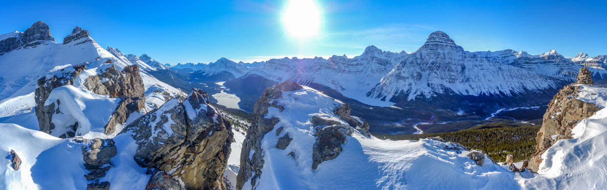
After weaving our way through the final ridge’s stegosaurus fins, we finally reached Spreading Ridge’s remarkably scenic summit. This one is going to be hard to top! Click to see larger.
.jpg)
.jpg)
LEFT: The ridge’s jumble of rock spines continues south towards Spreading Peak’s more impressive outlying buttresses.
RIGHT: Mount Patterson rises up beyond the Waterfowl Lakes. Spreading Ridge might be the most scenic snowshoe that I’ve ever done but it would be equally tempting to bushwhack up it during summer months when these lakes would fill the valley below like glorious blue gems.
.jpg)
Mounts Noyes and Weed highlight the southerly view on the parkway’s east side.
.jpg)
Bow Peak (left) and Crowfoot Mountain (right) rise up beyond Bow Pass.
.jpg)
For a summit that sported no online record of ascent, Spreading Ridge had a surprisingly substantial summit cairn! As Matt C. poked around the cairn to look for a register, he noted that the lichen coverage on its rocks was surprisingly uniform, suggesting that they’d not been disturbed (ie: piled up atop each other) recently. Since lichen takes decades to grow, it’s possible that this cairn was very, very old. After returning home, I consulted some additional resources and discovered that Spreading Ridge had been climbed at least once before (by a surveyor in 1927 prior to the existence of Highway 93 N)!
.jpg)
Aiguille Peak (left), Howse Peak (center) and Mount Chephren (right) tower above snow-covered Chephren Lake to the west.
.jpg)
To the northwest, the summit panorama was split. On the left, cold winter shadows crept across the Icefields Parkway. To the right, many-towered Mount Murchison was bathed in warm sunlight. Click to see larger.
.jpg)
Taking in the spectacular peak-filled view as the Parkway stretches north towards Saskatchewan Crossing.
.jpg)
Epaulette Mountain and Kaufmann Peaks across the valley. More distant Mount Outram is also visible between their pyramidal peaks.
.jpg)
A snow-covered glacier occupies Mount Sarbach’s impressive cirque.
.jpg)
Mount Erasmus rises up beyond Sarbach’s shoulder.
.jpg)
Mount Amery’s steep ramparts guard a surprisingly broad, glacier-clad summit plateau.
.jpg)
Looking north towards Bison Peak. A few months earlier, I’d stood atop it and wondered what the view from Spreading Ridge would be like. Now I’d discovered just how outstanding it was!
.jpg)
To the northeast, Matt C. grins from ear-to-ear while the panorama is filled by Mount Murchison’s many towers and a host of similarly impressive peaks. Click to see larger.
.jpg)
Spreading Ridge’s spiky summit mimics in miniature the towers beyond! From left to right: Bison Peak, Gest Tower, Southeast Tower, Cromwell Tower, Engelhard Tower and Hall Tower.
.jpg)
While I’d hoped for magnificent views, Spreading Ridge exceeded my wildest expectations. A top-10 summit view to be sure! 😍 Click to see larger (and don’t mind the grinning peak-bagger in the foreground).
.jpg)
.jpg)
LEFT: Southeast and Crowell Tower tower over frozen Totem Lake.
RIGHT: Vertiginous Totem Tower.
.jpg)
Looking east into the alpine valley and cirque that separate South Totem Peak (left) from Spreading Peak (right).
.jpg)
The unnamed but impressive buttresses that connect Spreading Ridge to its namesake peak.
.jpg)
A pair of Matts On-Top, surrounded by a myriad of towering peaks.
.jpg)
After soaking in the top-10 summit view, the business of getting back down was at hand. Spreading Ridge is a magnificent spot but we reasoned that it might be best to get down it before the impending sunset.
.jpg)
Our descent of the ridge forced us to face the day’s best view. With improving lighting and ever-shifting foreground boulder scenes, our progress was, initially, slow.
.jpg)
Posing as we prepare to leave the scenic ridge behind. Photo courtesy Matt Clay.
.jpg)
Matt C. gingerly descends Spreading’s steepest slope. At this point, his pace slowed considerably as he dealt with a knee issue. Fortunately, his pain proved manageable when he FINALLY took some ibuprofen (as opposed to just talking about taking it)!
.jpg)
Final views up the Icefields Parkway as we descended back into the late afternoon shade below tree line.
.jpg)
Matt C. carefully follows our broken trail down through the forest’s steepest sections. The tree on the right of the photo gives an indication of how deep the snow was and how difficult it was to plow a trench up through it!
.jpg)
After we retraced our steps through the forest’s minor cliff bands, we left our up-track behind, hoping to plot a more direct course down the mountain (after contouring unnecessarily on ascent). While trail-breaking was much easier with gravity on our side, that same gravity pulled a bit too hard from time-to-time, resulting in several slip-and-slide moments. Mercifully, the landings were soft!
.jpg)
.jpg)
LEFT: About 90 minutes after we left the spectacular summit, we crashed through the brush and found ourselves back at the highway.
RIGHT: From a statistical perspective, Spreading Ridge was a relatively small day (7 km return and 820 vertical meters). Nevertheless, the cumulative strain of the day’s trail-breaking efforts left me feeling exhausted to the point of nausea. Fortunately, I had a (now-slushy) treat waiting for me in the car. After a restorative ale at the foot of mighty Mount Chephren, I felt much better (re-hydrated anyways).
.jpg)
As I drove home, the sun began to set on the Icefields Parkway, casting its fiery alpenglow on the surrounding summits. Euphoric waves swept over me as I processed the day’s amazing scenery (which started before I arrived at the base of Spreading Ridge and continued as I drove home from it). As earlier, my commute was delayed by photo stops to admire and capture the glorious scenes that the Canadian Rockies were offering up. Spreading Ridge proved so scenic that even the drive to and from it left me awestruck (say nothing of its top-10 summit view)!
As hoped, my first ascent of 2021 provided an absolutely spectacular summit – one that’s going to be hard to top!
.jpg)
.jpg)
.jpg)
.jpg)