Indian Ridge and The Whistlers
Elevation: Indian Ridge - 2720 m, The Whistlers - 2464 m
Elevation Gain: Indian Ridge - 660 m, The Whistlers - 187 m
Indian Ridge was named by Morrison P. Bridgland for its red coloration in 1916 before the concept of political correctness. The Whistlers was named after a different kind of native – the hoary marmot – during the same year. Marmots, apparently, made quite an impression on early European visitors as a number of features (including: 6 peaks, 3 passes, 3 creeks, 1 river, 1 waterfall and 1 valley) in the Canadian Rockies have been named for these ubiquitous whistling members of the squirrel family.
My Ascents:
September 3 2011
Trailhead: Jasper Sky Tram Parking
Let there be light! After 3 straight days of inclement weather (despite a forecast that repeatedly called for sun), we finally awoke to blue skies in Jasper; and not a moment too soon. Previous scrambles up Roche Miette and Cinquefoil Mountain in cold wind and rain were starting to wear on Brianne and I. There had even been talk of driving straight home and skipping the scrambling all-together if day 4 dawned no different. Fortunately, the weather Gods had saved the best for last when it came to our Jasper trip and we would be treated to an absolutely spectacular day on Indian Ridge (and The Whistlers).
.jpg)
Thanks to a well-placed tram (money well spent), we were able to quickly and painlessly gain 973 m of elevation and "join the droves of puffing tourists hiking to the open plateau called Whistlers Summit." It wasn't long, however, until we had the beautiful alpine setting to ourselves.
.jpg)
Morning views of the Jasper townsite from just above the upper tram station.
.jpg)
After days of scrambling with overcast (understatement) weather, we were finally able to catch sight of Mount Edith Cavell (3363 m).
.jpg)
Captain Maturity (aka: Brianne) taking delight in crunching the ice that formed on puddles near the trail overnight.
.jpg)
After gaining a harrowing 187 m of elevation (have I mentioned how fond I am of trams?), we found ourselves atop The Whistlers. My 39th summit of the year (I'll take an easy one every now and then)!
.jpg)
The day's true objective: Indian Ridge as seen from the summit of The Whistlers.
.jpg)
From the summit of the Whistlers, we lost elevation, dropping into a beautiful alpine meadow at the col between Whistlers Mountain and Indian Ridge.
.jpg)
Indian Ridge starting to look a little more interesting! Most of the route up follows a well-defined path and is easy scrambling/hiking to the high point at the south end of the ridge.
.jpg)
The last bit of the route before gaining the ridge crest involves a slog up very loose scree (not much of a path here). Here the Boss tread-mills her way up near the summit
.jpg)
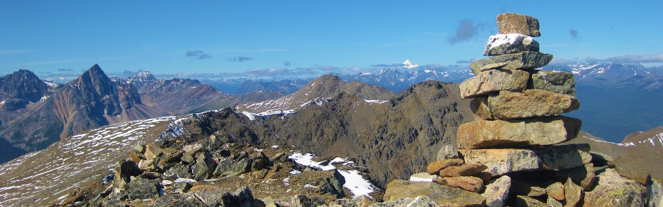
A spectacular summit view! The white point in the distance to the left of the cairn is the highest peak in the Canadian Rockies - Mount Robson.
.jpg)
Mount Robson is not only the highest peak in the Canadian Rockies (3945 m), but it is also the most prominent (2829 m from base to summit) peak in all of the Rockies.
.jpg)
Breezy and I on top! Our 4th summit in 3 days (poor girl)! At least the sun was shining on this one!
.jpg)
Indian Ridge summit panorama, from Mount Edith Cavell to the south to Mount Robson to the north. Click to see larger.
.jpg)
A beautiful tarn in the valley immediately west.
.jpg)
The unbelievably vibrant red rocks between snow-capped Manx Peak (left) and Fortalice (right) across the valley to the west made the reddish rocks on Indian Ridge seem dull.
.jpg)
The pointy Ramparts (Turret Mountain on the left, Mount Geikie on the right) in the distance beyond Fortalice Mountain.
.jpg)
The snowy Maligne Range to the south. Maligne Mountain in the center of the frame.
.jpg)
Monarch Mountain to the east in the Victoria Cross Range.
.jpg)
The aptly named Pyramid Mountain just north of Jasper.
.jpg)
Tired of me taking pictures! The Boss starts to make her way to the north end of Indian Ridge to complete the traverse. Pointy Roche Noire just left of her.
.jpg)
Meanwhile, I kept taking pictures...To the south: Mount Christie, Brussels Peak, Mount Fryatt and Mount Edith Cavell.
.jpg)
Hawk Mountain to the east. Roche Miette peeking out from behind Hawk Mountain on the left with the prairies beyond.
.jpg)
One of my favorite parts of this scramble was the traverse. As you traverse the ridge, the panorama changes and new peaks come into view. Terminal and Aquila Mountains now in front of Edith Cavell.
.jpg)
Stunning red rocks in the Victoria Cross Range.
.jpg)
Panorama from the north end of the ridge.
.jpg)
All smiles!
.jpg)
The north end of the Ramparts: pointy Barbican Peak.
.jpg)
The north end of the ridge offers an improved view of the Jasper townsite surrounded by small lakes.
.jpg)
Looking back along Indian Ridge. The Maligne Range on the left, Mount Kerkeslin in the center and Edith Cavell on the right. What a great traverse!
.jpg)
Getting to the challenging part where according to the “Don’t Waste Your Time in the Canadian Rockies” guide “only experienced rock climbers or mountaineers should proceed.” Here Brianne is just passed the narrowest most exposed section. While it was a little exposed, the section was quote short and shouldn’t really cause any problems for scramblers comfortable on moderate terrain.
.jpg)
Shortly after the narrowest bit, the ridge becomes more comfortable wide again, however, a large notch requires a steep, snowy detour off the north side of the ridge. This down climb could be made more challenging by snow/ice that tend to accumulate on the north side of things at this elevation!
.jpg)
The notch that forced our detour off of the ridge crest. Can’t just hop over this one!
.jpg)
The Boss past the notch – safe and sound.
.jpg)
Looking back along Indian Ridge to Edith Cavell. The Big Rock in Okotoks is an erratic that originates from the Tonquin Valley near here. That's a long way (~400 km) for a rock to travel!
.jpg)
Traverse completed! The north end of Indian Ridge.
.jpg)
The upper tram station on the right above Jasper. A long way to hike before the last tram down. First tram up: 10:00am, last tram down: 5:30pm...not exactly convenient hours for scrambling!
.jpg)
Back down in the rolling alpine meadows and looking back to Indian Ridge. Our descent took us down the prominent dark gully just right of center. The terrain in the gully was moderate but one would want to mind where they were going on descent here, lest they end up cliffed out!
.jpg)
Rambling across alpine meadows after scrambling across the ridge. The soft mosses of the meadow felt great underfoot after 3 straight days of scrambling! Pyramid Mountain across the valley.
.jpg)
One last view of spectacular Edith Cavell!
.jpg)
After being lulled by the peaceful confines of the alpine meadows, we had to regain 260 m of elevation to the summit of Whistler’s Mountain; from there, a quick, tourist-cluttered walk back down to the upper tram station awaited us.
.jpg)
Most mountain environments THIS dangerous don’t have a designated smoking area, boardwalk and benches. Just sayin’…
.jpg)
All the way back down! They packed us in like sardines in the tram. Does that thing look big enough to hold 30 people at the same time to anyone else?!
.jpg)
Yo Bear! Wildlife sightings along the Icefields Parkway provided highlights to an otherwise long drive home after a very successful 4 day trip to Jasper!
.jpg)
.jpg)