Little Hector
Elevation: 3125 m
Elevation Gain: 1260 m
Little Hector is the unofficial name for the high point just to the northwest of Mount Hector. Mount Hector is 270 m higher and is, therefore one of 54 peaks over 11,000 feet in the Canadian Rockies.
My Ascents:
August 25 2011
Trailhead: Hector Creek (roadside)
Nearby Mount Andromache has been on my “to-do” list for quite some time and in the process of researching Andromache trip reports, I came to realize just how close these 2 peaks are. It was at this stage that the idea of a two’fer was planted in my mind. Although I had dinner commitments in Calgary at 7:00pm, I convinced myself that it might still be possible to bag both summits – Little Hector first, followed by Andromache. Suffice to say that the reality of how long a day this would be hit me high up on Little Hectors treadmill scree slopes, at which time, I abandoned the goal of a two’fer. As consolation, I was treated to a magnificent view from the summit of Little Hector. Andromache’s summit will just have to wait for another day!
.jpg)
The view of the objective from highway 93. It doesn’t look so “little” from this angle!
.jpg)
The first in a series of waterfalls that can be surmounted by scrambling on the climber’s left. Below this, the route is in the forest but from this point on, the views become spectacular! Better still, it doesn’t take long to get to these waterfalls!
.jpg)
Above the waterfalls, you enter the wide and beautiful Hector Pass basin. The scramble route up Little Hector lies to the left while the route up Mount Andromache lies to the right.
.jpg)
A mossy little stream in the pass.
.jpg)
Early views of Mount Balfour.
.jpg)
The foreshortened view of Little Hector from the pass. It may not look that far, but it's still 900 vertical meters above! I followed the base of the cream/grey striped rib on the left of the photo to gain the plateau below the pyramidal peak.
.jpg)
The steep walls of Mount Andromache mask its easier ascent route a km or further up Hector Pass.
.jpg)
From the plateau, a massive pile of loose rock awaits.
.jpg)
Early views east into the Pipestone Valley. The snowy Cataract Peak lies behind the aptly named Molar Mountain.
.jpg)
Spectacular Hector Lake below beautiful Mount Balfour.
.jpg)
Turquoise Lake (above) and Margaret Lake (middle) slowly draining the melting Waputik Icefield into Hector Lake, and ultimately, the Bow River.
.jpg)
The breathtaking glaciated upper reaches of Mount Balfour.
.jpg)
After slogging up scree for what seemed to be a LONG time, I crested the ridge and was greeted by this view of BIG Hector for the first time! At last, the summit is close!
.jpg)
Big Hector and I from the summit of Little Hector.
.jpg)
Collapsed cornice on the ridge connecting Big and Little Hector. Although the two summits are close, getting up to the true summit of Mount Hector requires glacier travel and mountaineering.
.jpg)
The crevassed toe of the Hector Glacier, 3 km away in Hector Pass.
.jpg)
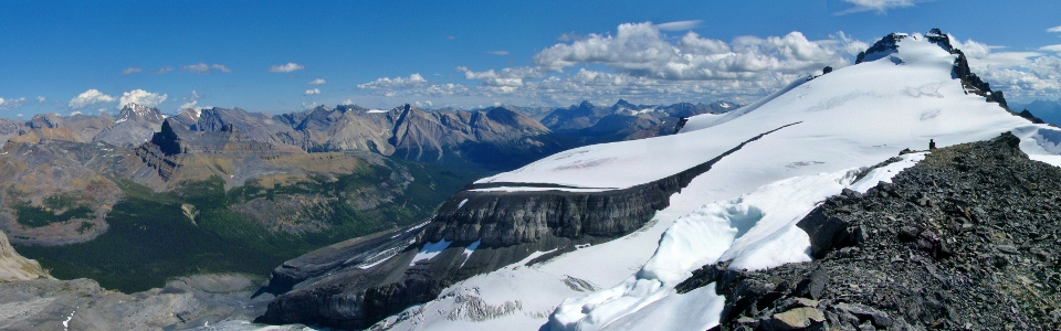
Hector panorama. Click to see larger.
.jpg)
Looking east across the Hector Glacier towards Pipestone and Skoki.
.jpg)
Cyclone and Pipestone Mountains.
.jpg)
Mount Douglas and St. Bride dwarf Oyster Peak in Skoki.
.jpg)
Cataract Peak beyond Molar Mountain.
.jpg)
Looking north over my other objective for the day Mount Andromache. By this point, I had already decided that getting down Little Hector, bagging Andromache and getting back to Calgary for dinner for 7:00pm was unrealistic.
.jpg)
M-shaped Mount Willingdon (3373 m) punctuates the horizon to the north beyond Andromache.
.jpg)
I decided to get myself in a couple of the summit photos to muck up the view.
.jpg)
Looking south past Mount Hector to the Lake Louise group.
.jpg)
Bident Mountain, Quadra Mountain and Mount Babel behind Temple.
.jpg)
The Lake Louise group to the left of the massive Goodsirs.
.jpg)
Lake Louise landmarks: Lefroy, Hungabee and Victoria.
.jpg)
Cathedral Mountain and Mount Stephen over Field and beyond the long ridge of Mount Daly.
.jpg)
Awesome view of the spires/crags on Cathedral Mountain.
.jpg)
Looking north towards Bow Lake and the Wapta Icefield.
.jpg)
A head-on view of the Dolomites with Cirque and Observation Peaks behind. The many towers of Mount Murchison can be seen beyond.
.jpg)
A very distant, very high (3612 m) Mount Forbes is visible far behind Bow Lake.
.jpg)
The eye-catching Mount Chephren, appropriately named after an Egyptian pyramid-builder.
.jpg)
Icefields Parkway panorama: from Hector Lake to Bow Lake. Click to see larger.
.jpg)
Icefields panorama: from the Waputik Icefield to the Wapta Icefield. Click to see larger.
.jpg)
Mount Mummery - from the center of the panorama above.
.jpg)
A small tarn collects runoff from the glaciated Mounts Gordon and Olive on the Wapta Icefield.
.jpg)
Don't let the blue skies and sun fool you - it was actually quite cold up here! Must mean that it's time to get down!
.jpg)
After a rapid scree descent, I was back down in Hector Pass surrounded by marmots!
.jpg)
Strange old bridge I ran into in the forest. Not sure how I missed this on the way up... Almost down at the car.
.jpg)
Moments after getting into my car, I ran into this fellow just down the highway! Glad I didn't run into him earlier solo in the woods! Better still, I saw another one of his friends one km further down the highway. Yo bear!
.jpg)
.jpg)
.jpg)