Mount Edith
Elevation: 2554 m
Elevation Gain: 1120 m
Mount Edith, like its more prominent neighbor to the north Mount Louis, is a dogtooth mountain formed by the vertical uplift of Palliser limestone. This vertical limestone is harder than the rock which originally surrounded it and was left behind as a gravity-defying erosional remnant as the softer rock eroded away. The Edith massif is made up of 3 such dogtooth peaks, of which the northernmost is the highest. Mount Edith was named for Edith Orde who was Lady Agnes MacDonald’s attendant on her rail journey through the Rocky Mountains. Edith Orde glimpsed Mount Edith from Edith Pass, where she was hiking with Louis Stewart and her Dog “Fifi”. Nearby Mounts Louis and Fifi were also named that afternoon for the other members of her hiking party. The peak was first ascended by Norman Collie and a reluctant Fred Stephens in 1900.
My Ascents:
July 1 2011
Trailhead: Cory/Edith Pass Trailhead
Happy Canada day! How best to celebrate? Silly question; climb a peak of course! Better still if it’s a two’fer. Much better still if it’s a three’fer! While Mount Edith’s 3 peaks do present the opportunity for a three’fer, I knew that, with tickets to the Stamps home opener that night, I would be hard-pressed to bag all 3 in time to get back to the city for the game. Regardless, I set out solo with the intention of making my way up as many of Edith’s peaks as I could before game time!
.jpg)
I had forgotten how much of a grunt the early part of the Cory Pass trail was! Fortunately, with views like this of Mount Rundle and Vermillion Lakes, I had plenty of chances to stop for pictures (and maybe to catch my breath).
.jpg)
Train!
.jpg)
Mount Brewster through the woods.
.jpg)
The objective, Mount Edith, finally comes into sight. Cory Pass is on the far left and Edith’s true summit (the north summit) is the peak just to the right of the pass.
.jpg)
Looking up to Mount Edith's steep faces from the Cory Pass trail. While Edith’s north peak (far left) may be the highest, the south peak is by far the most impressive from this angle!
.jpg)
At the pass! From here, a great deal of the elevation has already been gained. What remains is, for the most part, a scree grunt until the final 50 meters or so when things take a turn for the exposed.
.jpg)
Mount Louis is beautifully revealed from Cory Pass.
.jpg)
After making my way up the scree, I ditched my pack so that I could fit while wriggling my way up the easier south-facing chimney near the summit. From Kane’s description, I anticipated some difficulties here, however, I’m happy to report that, other than claustrophobia, one is unlikely to encounter difficulties (in this chimney at least). I’m not sure why Kane makes such a big deal about the chimneys in his description; especially when you consider what he glosses over next…
.jpg)
Whoa, whoa, whoa, whoa, whoa…I need to do what? According to Kane: "At the summit cross a notch to reach the cairn." The term “notch” does not really do this vertigo-inducing chasm justice. Be prepared for THIS if you want to climb Mount Edith.
.jpg)
The summit cairn on the other side of the 'notch', taunting me.
.jpg)
Staring into the abyss trying to work up the balls to cross it.
.jpg)
Across and on the summit! And not overly thrilled by the prospect of having to do it again on the way back.
.jpg)
Exposure on all sides...
.jpg)
Mount Cory on the other side of Cory Pass.
.jpg)
Mount Bourgeau beyond Mount Cory.
.jpg)
Looking south along the sawback ridge connecting to the other high points on Mount Edith.
.jpg)
The usual Banff landmarks: Mount Rundle.
.jpg)
The usual Banff landmarks: Cascade Mountain.
.jpg)
Vertical Mount Louis dominates the skyline to the north.
.jpg)
Zoomed in on the summit of Mount Louis. I kept hearing distant voices on the wind in this direction. Not sure if they were from climbers and if their voices would carry across the Valley of the Gargoyles. I wasn’t able to spot anyone all day, however.
.jpg)
Group summit shot: Fifi, Louis and I. Time to hop back across that damned notch!
.jpg)
Back across the 'notch'. Terra firma! Actually, the leap on the way back wasn’t as bad due to the fact that, going in this direction, the other side is higher so you don’t have to look down the chasm that you’re trying to cross. It is, nevertheless, a disconcerting feeling to be stepping over air and nothing else.
.jpg)
Enjoying the view a little more now that I'm safely across the notch!
.jpg)
Looking towards Mount Howard Douglas and Eagle Mountain (aka: Sunshine) to the left of Mount Bourgeau. So much for Canada day skiing!
.jpg)
Mount Fifi (right) in the sun beyond an unnamed high point.
.jpg)
Mount Cory towers above Cory Pass. Although the clock was ticking down towards kickoff, the center summit looked tantalizingly close...time to get moving if I want to make this a multi-peak day, I suppose!
.jpg)
Last view of Mount Louis framed by two pinnacles before leaving the north summit.
.jpg)
Some hard snow and ice made the chimney a little more challenging to descend.
.jpg)
Leaving my mark on the chimney...
.jpg)
...and the chimney leaving its mark on me.
.jpg)
The "short but entertaining" scramble to the slightly lower central peak of Mount Edith.
.jpg)
Exposure en route.
.jpg)
Looking back to the true summit. Great vertical strata.
.jpg)
Downclimbing a short section before the central peak.
.jpg)
Looking over to the even more exposed south peak of Mount Edith.
.jpg)
For my money, the views from the central summit were actually better than those from the true summit!
.jpg)
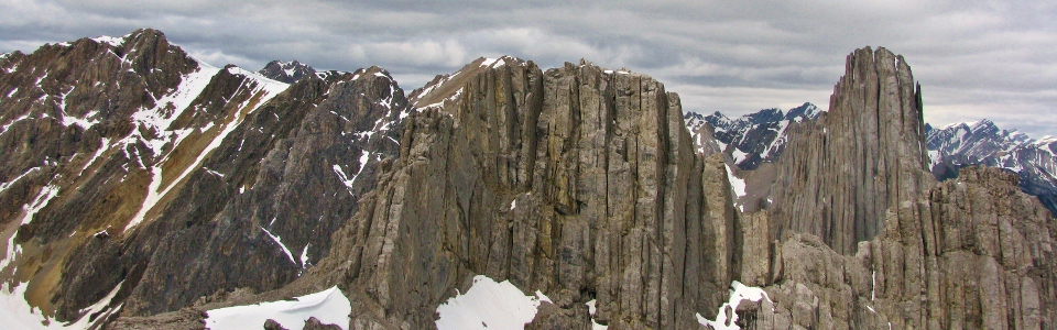
Central peak panorama, from left to right: Mount Cory, Mount Fifi, Mount Edith summit, and Mount Louis. Click to see larger.
.jpg)
A long way down to the Cory Pass trail...mind your step.
.jpg)
Mount Norquay in the sun with snowy Mounts Girouard and Peechee beyond to the left.
.jpg)
On the central summit in front of Mount Brewster. I'm counting this as a separate summit for the record...#13! A Riders' dozen!
.jpg)
Some other scramblers in a bit of a predicament on the more difficult south peak of mount Edith. Due to cold temperatures, all of the snow was hard and very icy.
.jpg)
...zoomed out a little. The scramblers carefully make their way down the south peak.
.jpg)
...zoomed out all the way. Tiny scramblers still visible (just) near the top of the snow chute. At this point I had been looking at the south summit for the better part of 2 hours, and I never saw them on top. I suspect the snow turned them back. Snow in my descent gully between the south and center peaks similarly turned me back, forcing me to descend the way I'd come up, on the Cory Pass trail. Fortunately, I made good time and was back in town in time for kickoff! Too bad we lost…
.jpg)