Mount Kidd South Summit
Elevation: 2895 m
Elevation Gain: 1290 m
Mount Kidd was named after Stuart Kidd, a Morley resident who outfitted early Kananaskis expeditions. The peak was named by D. B. Dowling in 1907. Dr. Dowling’s party with the geological survey of Canada would likely have found Mount Kidd to be particularly interesting as the peak represents the northern extremity of the 450 km long Lewis thrust which forced older Precambrian rock over Cretaceous rocks which are 1.4 billion years younger than those which now rest atop them. Mount Kidd has two prominent high points, the more northerly of which is the true summit.
My Ascents:
July 18 2011
Trailhead: Galatea and Lilian Lakes Trailhead
Cloudless blue skies, hot summer sun and zero chance of precipitation; Mondays like this are made for scrambling so I set my alarm, packed my bag, grabbed my boots and made haste for K-Country! After scaring myself a little on my solo scramble up “moderate” Mount Lawson last week, I wasn’t eager to take on any technical objectives so I set my sights on Mount Kidd’s easier south summit. I had already climbed the slightly higher north summit last year, however, the weather on that particular day was dismal and I was keen to actually see the view from the top this time!
.jpg)
A great way to start the day: beautiful views of the objective, the south Summit of Mount Kidd.
.jpg)
The slightly higher north summit of Mount Kidd.
.jpg)
Enjoying the novelty of a well-beaten approach path after having to fight through the forest earlier in the week on Mount Lawson.
.jpg)
Pretty views along the Galatea Creek approach trail.
.jpg)
After following the trail until a little passed the sixth bridge, I turned upslope and started making my way up the painfully steep avalanche gully that Kane suggests you use to ascend. Gaining elevation at an ungodly pace had its benefits, however: great views of the Fortress on ascent.
.jpg)
Looking towards the summit from about half way up the avalanche gully. From this point I gained the rocky ridge on the left to avoid having to sidehill along near the slabby creek in the center.
.jpg)
Beautiful alpine meadows highlighted by the Tower.
.jpg)
The summit looking deceptively close, yet still a long plod up rubbley away.
.jpg)
Alpine rock garden.
.jpg)
Topping out on the summit ridge, Mount Bogart is revealed to the north.
.jpg)
The summit ridge itself provides the only interesting scrambling of the day.
.jpg)
If the steepness of the ascent doesn't take your breath away, the view will. This is certainly one of the finer viewpoints in K-Country!
.jpg)
Awesome views: the Tower and Mount Engadine above Galatea Lakes; Mount Assiniboine punctuating the horizon.
.jpg)
The always sexy Ms. Assiniboine.
.jpg)
Assiniboine panorama: Mount Eon, Mount Aye and Mount Assiniboine. Click to see larger.
.jpg)
Mount Bogart.
.jpg)
The summit block of Bogart. Looks intriguing...
.jpg)
Beyond the north summit of Kidd, lie a few smaller peaks and the prairies.
.jpg)
The prairies on the other side of Barrier Lake and Mount Baldy.
.jpg)
The Tower, Mount Engadine and Galatea Lakes.
.jpg)
The Tower's steep summit block.
.jpg)
Galatea Lakes.
.jpg)
Beautiful green valleys running along the base of (from left to right): Mount Lawson, Mount Inflexible, Mount James Walker, the Fortress, and Gusty Peak.
.jpg)
Awesome summit panorama. Click to see larger.
.jpg)
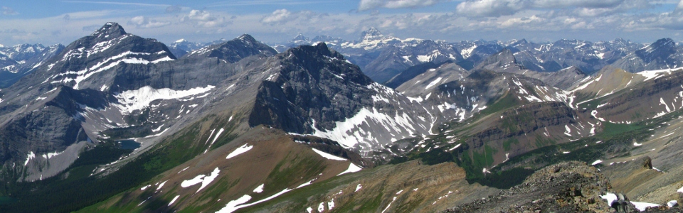
From left to right: Mount James Walker, the Fortress, Mount Chester, the British Military group, Gusty Peak, Mount Galatea, Mount Birdwood, Mount Smuts, the Tower, Mount Engadine and of course, Assiniboine. Click to see larger.
.jpg)
The Fortress’ fortress-like north face in front of Mount Chester.
.jpg)
The redoubtable Mount Smuts.
.jpg)
Group summit shot: myself, Bogart and a cairn. I think that's everyone.
.jpg)
No scramble-able route to the north summit from here.
.jpg)
The north summit, complete with eyesore telecommunications station.
.jpg)
A long way down to the north. Undoubtedly where the poor fellow met his untimely end on this peak last year.
.jpg)
Leaving my mark.
.jpg)
Looking back along the summit ridge to Mount Nestor and Old Goat Mountain.
.jpg)
Highway 40 and the Kananaskis Valley. The old Fortress ski area to the right.
.jpg)
Can't get enough of this view!
.jpg)
The Tower holding my wallet hostage.
.jpg)
The Fortress, Mount Chester and Gusty Peak in front of the British Military Group.
.jpg)
Mount Sir Douglas: the most prominent member of the British Military Group.
.jpg)
Fisher Peak still holding snow to the east.
.jpg)
Looking deeper south into K-Country: Mounts Lawson, Inflexible and James Walker above the old Fortress ski area. Mount Joffre prominent in the background.
.jpg)
The evil Mount Lawson, site of last week's misadventure. The ascent route goes straight up or alongside the long snow gully.
.jpg)
Mount Joffre.
.jpg)
Mount Galatea above Lost Lake. Not entirely certain why Galatea Lakes are below the Tower and Lost Lake is below Galatea...
.jpg)
According to Nugara, the pointy Old Goat Mountain is a scramble. I have my doubts.
.jpg)
Soaking in the scenery before trudging down.
.jpg)
Massive spider. This thing must eat marmots.
.jpg)
Last views of Galatea as elevation is quickly lost. The lower down I got, the hotter it got! Despite bringing 4 L of water, I still ran out on this scramble! When I got home, I weighed myself out of curiosity and was shocked to discover that I had lost 5 lbs on this scramble (despite drinking 8 lbs of water)!
.jpg)
Wildflower season appears to have hit the front ranges. A scenic end to a very scenic day!
.jpg)
.jpg)
.jpg)