Mount Lineham
Elevation: 2728 m
Elevation Gain: 1100 m
John Lineham was a wealthy politician who passed away at the relatively young age of 56 in 1913. His estate inherited a fortune of $436,000 (an impressive sum today, let alone in 1913). The mountain was named in his honor in 1916. The peak contains a geological feature rarely observed in the Canadian Rockies: a prominent band of igneous (volcanic) rock.
My Ascents:
October 19 2011
Trailhead: Rowe Tamarack Trailhead
With the snow falling and the weather turning wintery in the more northern ranges, I decided to head south for an escape to beautiful Waterton! Although the 3 hour drive usually discourages me from bagging Waterton peaks as day-trips, I have to admit that the drive was not that bad – even solo. Nevertheless, the short October days necessitated a very early start to make this feasible! Thanks to being unemployed, I arrived at the Rowe Lake parking lot on this particular October Wednesday morning to find that I had the trail (and presumably the peak) all to myself!
.jpg)
The highway-side view of Mount Lineham from the Akamina Parkway. Although the summit is only 3 km from the highway, it rises an impressive 1100 vertical meters! A faintly visible black band just above the tree line is Purcell Sill of volcanic origin.
.jpg)
A cold morning hiking up along Rowe Creek.
.jpg)
The view of a snowy Tamarack trail from Rowe Meadows. After being stuck in a lightning storm on this trail as a child, I was relieved to see that the weather appeared to be more stable this time!
.jpg)
Mount Lineham's steep, but non-technical south face. The farther of the two avalanche chutes provided a relatively quick descent for me a few hours after this shot was taken. Glissade!
.jpg)
Looking back at the Tamarack trail (my ascent route) crossing steep snow slopes.
.jpg)
The view of Mount Lineham from near the apex of the Tamarack trail. From here, the route follows the snowy ridge-top to the summit. Although this is usually little more than a scenic plod, hard icy snow made it more interesting on this particular ascent.
.jpg)
Upper and Lower Rowe Lakes reveal themselves in the valley below as elevation is gained. The craggy peak in the distance is Citadel Peak which towers above the west side of Waterton Lake.
.jpg)
Closer view of the crags.
.jpg)
Mount Blakiston (the highest point in Waterton National Park) high above one of the many Lineham Lakes.
.jpg)
Several of the Lineham Lakes at the foot of Lineham Ridge.
.jpg)
The summit of Mount Lineham, still a surprising distance away along the snowy, crusty, icy, windy ridge.
.jpg)
Sunnier skies behind me to the west in BC.
.jpg)
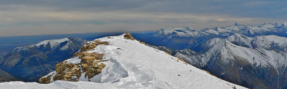
At long last, the summit cairn of Mount Lineham appears at the end of the ridge!
.jpg)
Posing for summit #52 in front of more impressive peaks (Mount Peabody, Kintla Peak and Kinnerly Peak directly behind me) to the south in the USA's Glacier National Park.
.jpg)
An icy upper Rowe Lake in the foreground. The popular Cameron Lake on the left further back.
.jpg)
Cameron Lake. The massive headwall (Mount Custer) at the back of the lake is the Canada/US border.
.jpg)
Foreground: upper Rowe Lake. Center: Akamina Ridge. Background: Mount Peabody, Kintla Peak and Kinnerly Peak.
.jpg)
The basin between Mount Peabody and Kintla Peak beyond Akamina Ridge reveals the tell-tale signs of recent glaciation. Unfortunately, the glacier that once carved it out is all but gone at this point.
.jpg)
Unlike other areas of the mountains where foothills provide a lead-up to the mountains, in Waterton, the prairies meet the steep slopes rather abruptly. Here the rounded top of Mount Crandell provides the leading edge of the mountains before giving way to endless flat lands beyond.
.jpg)
Posing over the prairies. The cone-shaped Chief Mountain visible behind. Based on the look of my pants, it may have been a little windy...
.jpg)
Chief Mountain (left) is the leading edge of the Lewis Thrust, a geological event which pushed older rocks a distance of some 70 km over younger ones. The northern edge of the thrust is visible in the form of scenic Mount Kidd in Kananaskis Country, hundreds of kilometers to the north.
.jpg)
Debuting a new summit pose: the triceratops.
.jpg)
Looking north into the mountains of the Castle region.
.jpg)
Hard crusty snow made me happy to have crampons!
.jpg)
Mount Galwey must feature a remarkable view of how flat the prairies are.
.jpg)
If there was a summit register, it was encrusted in snow and ice...
.jpg)
Rather than traversing all the way back along the crusty and icy ridge, I opted for a faster descent...
.jpg)
This avalanche gully on the south face of Mount Lineham provided just such an escape, however, the route is uncomfortably steep (especially when slippery) near the top. Still, the glissade probably cut and hour and a half off my descent time.
.jpg)
Beautiful fall colors back in the land of the living on descent. The red-tinged Buchanan Peak lies at the end of the Rowe Valley with the rounded-top Mount Crandell beyond.
.jpg)
Since I drove all the way down to Waterton for the day, I figured I may as well do some sightseeing once I was down! Vimy Peak catches the evening light beyond the famous Prince of Wales hotel.
.jpg)
Vimy Peak and Waterton Lake.
.jpg)
Beautiful Waterton Lake surrounded by the previously mentioned craggy peaks. Citadel Peak on the right was visible from the summit of Mount Lineham.
.jpg)
Sofa Mountain giving way to lake giving way to prairies. Fall giving way to winter.
.jpg)
The characteristic abrupt change from prairie to mountain near the Waterton park gates marking the beginning of a long drive home.