Nihahi Ridge
Elevation: 2545 m
Elevation Gain: 900 m
Nihahi Ridge is the first major obstacle encountered as one drives west from Calgary towards the Kananaskis front ranges. It was named (and aptly so) in 1922 for the Stoney word for “rocky”.
My Ascents:
October 8 2011, November 7 2010
Trailhead: Little Elbow Day Use Parking Lot
A recent dump of October snow gave me heart palpitations. After working so hard to accomplish my goal of 50 summits this season, I had successfully bagged 49 to date and I could feel the icy grip of winter closing in around me. With the aim of bagging that 50th peak before winter could deprive me of it, I set my eyes on a front-range peak reasoning that there was likely to be less snow. Nihahi seemed a good choice since I had successfully ascended it at least once before and was comfortable with the route. Gord, who has been hiking up to a high point (below where the scrambling on the ridge starts) for many years now, decided to join me since he had never gained the actual ridge-top. I, of course, obliged; I couldn’t ask for better company for what I hoped would be my season’s milestone summit!
.jpg)
Fall colors in the Little Elbow Valley. Things looking ominously winter-y higher up.
.jpg)
Breaking trail just below the ridge crest. Having hiked to lower points on the ridge many many times, we kept the cameras in the backpacks until higher up.
.jpg)
The early portions of the ridge. Snow dunes are never a good sign.
.jpg)
Gord taking on the last of the snowy scree before gaining the ridge crest.
.jpg)
Not as snowy as we had feared - for now.
.jpg)
High on the ridge crest and contemplating the merits of continuing on over ever more technical terrain with ever more snow covering it. Don’t worry – we decided to continue on!
.jpg)
Banded Peak beyond my contemplations.
.jpg)
Calgary and the expansive prairies beyond.
.jpg)
Tiny buildings.
.jpg)
After careful contemplation, we opted to gain the highest portion of the initial ridge crest, leading us to this point where a traverse of a snowy, slabby ridge crest is still required to gain the high point directly behind me. We chickened out and took photos from here instead. For now...
.jpg)
Another group following our trail up. Several of them gained the ridge crest, but opted not to come as far as we had, citing that 'a ridge is a ridge'.
.jpg)
The slab doesn't look dangerously steep, but when wet, icy and snow-covered, crossing it was unnerving.
.jpg)
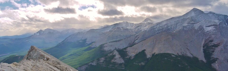
Mount Glasgow and Banded Peak beyond.
.jpg)
Flat-topped Mount Remus (left) and Fisher (right) to the west.
.jpg)
Fall colors dominate to the east.
.jpg)
Winter colors dominate to the west. The backside of Opal range peaks Mounts Blane (left) and Brock (right).
.jpg)
Mounts Fullerton and Howard to the north. Fullerton is an enjoyable scramble that features a miserable 10+ km approach; even more miserable after descent when you just want to get back to your car!
.jpg)
After taking pictures and acclimatizing to the conditions on the ridge, we opted to continue onwards in spite of the slick, cold conditions. Summit #50 or bust apparently.
.jpg)
It all started off well enough...
.jpg)
Before long, however, style points went out the window. Bruising my knees and shins while freezing my hands, I crawled to my 50th summit of the season!
.jpg)
Unfreezing my hands in the most effective manner on top of #50.
.jpg)
The ridge continues along, arrow-straight for 7-8 km to the north. Perhaps a full traverse is in order when drier (and warmer) conditions prevail.
.jpg)
Gord joining me for my 50th! A day later, he got to drive back out to Nihahi Ridge to see if he could find his hiking boots which he left in the parking lot on our way home. Lucky for him, the boots were frosty but still there!
.jpg)
Having successfully traversed back across, and subsequently scrambled off the ridge crest, all that is left is a hike back to the car. Last views of the Little Elbow River on descent.