Anthozoan Mountain
Elevation: 2695 m
Elevation Gain: 945 m from Skoki parking area - 455 m from Baker Lake.
Like other nearby peaks of the Slate Range, Anthozoan Mountain was named in 1925 for the preponderance of fossils found on its flanks. Anthozoan is a variety of fossilized coral common in the Devonian limestone that makes up this long north-south oriented ridge.
My Ascents:
August 4 2012
Trailhead: Baker Lake Backcountry Campground
.jpg)
Fresh off our first ascent of the day (Brachiopod Mountain), Brianne tackles the scree slopes leading to the north (false) summit of Anthozoan Mountain. The scree was actually quite solid and made for a more pleasant than anticipated ascent.
.jpg)
Mount Victoria comes into view as we ascend.
.jpg)
Mount Fairview is absolutely dwarfed by Victoria.
.jpg)
On the north (false) summit of Anthozoan. The true summit is over a km of scrambling away and according to my altimeter was only 10 m higher.
.jpg)
Leaning on the (false) summit cairn. Used to rain and snow an unaccustomed to the hot sun, we were both starting to fatigue a little at this point 5 days into our back-packing adventure.
.jpg)
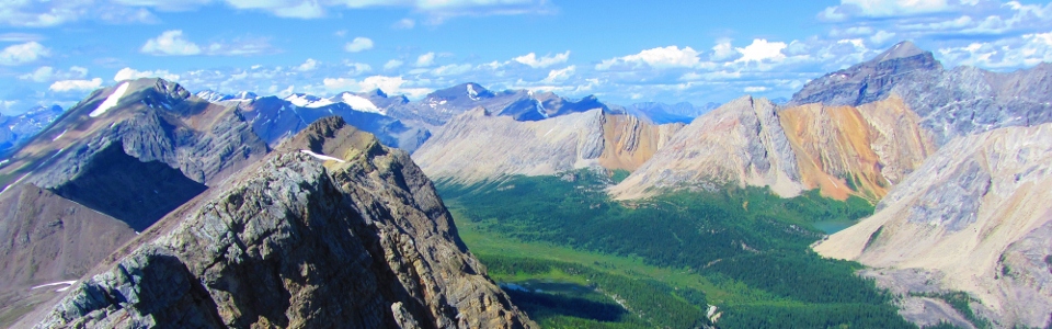
The view to the north was highlighted by Mount Richardson, Ptarmigan Peak, Mount Hector (distant), the Wall of Jericho and Brachiopod Mountain.
.jpg)
Closer up.
.jpg)
The highest peak in the Skoki area - Mount Richardson. Mount Balfour and the icefields beyond.
.jpg)
After a quick break on the false summit, we were off to explore the ridge to the true summit. The scrambling along the early section of the ridge was actually quite fun.
.jpg)
Getting more and more fun! This bit was actually the crux of the ridge traverse and wasn't nearly as bad as it looks - moderate terrain at worst.
.jpg)
Almost there! The ridge near the true summit is plagued by false hope-inducing bumps, each of which appears to be the summit until you get there and realize that there's another slightly higher bump just a bit further...
.jpg)
Moraine Lake just comes into view at the foot of the Valley of the Ten Peaks.
.jpg)
Mounts Redoubt, Balfour (distant) and Richardson in front of the suddenly visible Redoubt Lake.
.jpg)
A completely different perspective of the Castle Mountain massif to the south. Stuart Knob on the left and Television Peak on the right.
.jpg)
At long last, the summit of Anthozoan and a successful two'fer!
.jpg)
Looking back along the ridge to Brachiopod and Fossil Mountains. Oyster Peak is the long ridge in the center of the photo while Mount Douglas dominates the horizon on the right.
.jpg)
To truly appreciate the peaks of the Lake Louise region, you have to come across the highway and climb in the Skoki area to see them!
.jpg)
Remote peaks to the east.
.jpg)
Skoki staples: Mounts Douglas and St. Bride.
.jpg)
Finally a summit register on a Skoki peak! Although a summit register had been a key component in my planned proposal to Brianne, I eventually gave up after being unable to find one on the three other peaks that we climbed in the area (I just bit the bullet and got down on one knee and proposed like normal men do the day prior on Fossil Mountain). This entry was the last recorded ascent of Anthozoan, meaning that we were likely the first people on this peak in almost a year! I suspect that most parties settle for the false summit and save themselves a lot of time on the ridge!
.jpg)
Register poetry. Viewer discretion is advised.
.jpg)
On a more romantic note...without a summit register on Fossil Mountain to record our big news, we instead forged an entry on Anthozoan so that our engagement could go down in the annals of mountaineering.
.jpg)
Celebrating the two'fer (and the engagement) by shooting off her bear banger. The bear banger didn't work. Good to know...
.jpg)
Getting tired...a long way to go back too!
.jpg)
A good glissade always takes the edge off though!
.jpg)
Fast forward to setting sun on Baker Lake as we pull back into camp. The successful two'fer concluded our time in the Skoki area for this year. All that was left was our hike out and return to civilization the next morning.
.jpg)
The next morning we awoke to this view across Baker Lake. Normally seeing a grizzly at this distance would not have been alarming except that we proceeded to watch the bear round the lake and start coming back down the trail that we needed to hike out along in 10 minutes or so...
.jpg)
We made plenty of noise as we hiked along the path that we had just watched the bear go down and fortunately, we didn't make his acquaintance. We did, however, find this baby ptarmigan fiercely guarding the path.
.jpg)
Mom wasn't far away. We found them just above the banks of Ptarmigan Lake and below Ptarmigan Peak. Won't have to wonder how those got their names anymore...
.jpg)
Pleasant hiking through the meadows...only 2 hours away from greasy food at this point!
.jpg)
Last views of Mounts Lefroy and Victoria beyond Ptarmigan Lake on the hike out.
.jpg)
So this is what Boulder Pass looks like when it's not blizzarding... Only the dull and rock hard Temple fire road between us and an air-conditioned car at this point!
.jpg)
Sore shoulders :(
.jpg)
I know how to turn that frown upside down! Celebrating another successful adventure (1 engagement, 1 birthday and 4 new peaks bagged) with 2400 calories...each!!!