It’s that sad time of year again. The temperature has dropped, the snow has started to fall and the days are becoming depressingly short. Mother Nature is sending a pretty clear message that the reasonable scrambling season is rapidly drawing to a close. It’s at this time of year that I’m usually forced to scale back my ambitions and have to start settling for less impressive peaks (either that or learn to be content sitting on a warm couch at home). Woe is me.
Ah, to hell with it! Despite all of the above, I decided that if I was going to be dragged into the scrambling off-season, it would be kicking and screaming (and – as it turned out – mountain biking). I’ve had my eye on Banded Peak for years but the long approach has always made it difficult to find a partner willing to tackle it. Fortunately, my dad shares my delusional ideas of reasonable scrambling trip ideas and, with the blessing of a nice forecast for the long weekend Sunday, I was able to convince him to dust off his mountain bike and take a run at beautiful Banded Peak!
.jpg)
Alpine start anyone? In order to take advantage of every bit of daylight possible, we arrived at the trailhead well before sunrise – Kane does, after all, mention that Banded Peak is a “FULL day even with mountain bike approach.”
.jpg)
Crossing the Elbow River as the first light of dawn begins to illuminate snowy peaks. From here, we have a short 15.2 km mountain bike ride to get to the Banded Peak trailhead. Oh yea, neither Gord nor I have ever been mountain biking…
.jpg)
Sunrise on the aptly named Threepoint Mountain. Gord taking on the generally pleasant (so far anyways) Big Elbow bike ride.
.jpg)
Although the morning sun had started to hit the peaks, it took much longer for it to reach the valley bottom where we peddled away the miles to Banded Peak. We had been banking on snow at higher elevations but we had hoped that the bike approach would be snow-free. Alas, it was not. What followed was a somewhat miserable bike ride through ~10 cm of crusty icy snow – the kind that delights in throwing your bike tires to and fro without regard for your intended course.
.jpg)
Kane describes the scramble route as starting following a rise on the bike trail. As always, he is the king of understatement. The "rise" he speaks of is massive and will force all but the heartiest of mountain bikers to dismount and walk up hill amidst feelings of shame and inadequacy. Fortunately, this makes the trailhead obvious. If it’s still not obvious enough, here’s a photo of it. We stashed our bikes in the woods across the Big Elbow trail from this cairn.
.jpg)
Finally off that painful bike seat! The route up to the Banded – Outlaw col visible snaking up the valley behind me. The White peak at the head of the valley is Outlaw Peak. Banded Peak is still out of sight to the right. The well-worn trail was generally easy to follow and, even when it wasn’t, the route-finding was trivial.
.jpg)
Getting closer to the Banded – Outlaw col. The path crossed the first drainage in the foreground before rapidly dissipating. From here, we crossed the drainage on the left and easily gained the col to the left of the waterfalls at the end of the valley. Above the waterfalls, an obvious path cuts back to the right through the scree towards the summit of Banded Peak.
.jpg)
Isn’t it a little cold for that?
.jpg)
The elevation gain on this ascent is slow and tedious until shortly before the Banded – Outlaw col. Fortunately, the more rapid ascent here quickly propels you into magnificent scenery – particularly with a nice dusting of snow. Here, the peaks of the Highwood Pass region (Mist Mountain and Storm Mountain) begin to come into view in the distant center.
.jpg)
Almost there! The view from the col is spectacular. From here one can scout out the entire Glasgow – Cornwall – Outlaw – Banded four’fer traverse. Perhaps I’ll save that one for a day with more than 11 hours of daylight! Click to see larger.
.jpg)
Ready to take on the final suggestive-looking summit block of Banded Peak.
.jpg)
The wind carved interesting snow dunes on the south-west slopes of the peak. The dunes were a nice microcosm of the peaks surrounding them. That’s my attempt at being artsy.
.jpg)
Slog, slog, slog, slog, slog, slog, slog, slog, slog, slog, slog, slog, slog. Poor old man. The final 150 vertical meters are a grind.
.jpg)
The reward for a lot of hard work! Gord steps onto the summit scene amidst an impressive panorama.
.jpg)
Matt towers above the prairies on the summit of Banded Peak!
.jpg)
Gord likewise.
.jpg)
Threepoint Mountain is as beautiful from above as it was from below.
.jpg)
Looking down Banded’s steep east face (ie: its band) towards the prairies beyond.
.jpg)
Banded Peak is one of the most visible peaks on the horizon from Calgary – it only stands to reason that Calgary would be highly visible from Banded as well.
.jpg)
Telephoto shot of Calgary from the summit of Banded Peak.
.jpg)
Given its location in the front-ranges, Banded Peak boasts an impressive eastern panorama! From left to right: Mount Cornwall, Mount Romulus (flat top), Mount Remus (flat top), Mount Glasgow, Nihahi Ridge, Moose Mountain (distant), Threepoint Mountain and Bluerock Mountain. Click to see larger.
.jpg)
Mount Glasgow, Nihahi Ridge and Moose Mountain (distant right).
.jpg)
Looking through the Cornwall – Glasgow col to flat-topped Mounts Romulus (left) and Remus. Fischer Peak is the larger pyramid behind Romulus.
.jpg)
More distant still, massive Mount Aylmer is visible dominating the front-ranges on the horizon.
.jpg)
Panorama to the north showing the entire Banded – Outlaw – Cornwall – Glasgow traverse. Click to see larger.
.jpg)
The impressive east-facing cliffs of Outlaw Peak and Mount Cornwall.
.jpg)
The Opal range beyond Outlaw Peak and Mounts Eon, Aye and Assiniboine more distant still.
.jpg)
Mounts Bogart and Lougheed make appearances just behind the summit of Mount Cornwall (to the left and right of the summit, respectively). Fischer peak is the large mountain on the right.
.jpg)
Also behind Mount Cornwall: Mount Nestor and pointy Old Goat Mountain, which stand above Spray Lake.
.jpg)
Trying to set up a summit group shot!
.jpg)
Success!
.jpg)
Panorama to the south towards Highwood Pass. Stunning views all around! Click to see larger.
.jpg)
The peaks of the Highwood Pass area dominate the view to the south. From left to right: Mist Mountain, Storm Mountain and Mount Rae.
.jpg)
Mount Rae looks quite different from this perspective.
.jpg)
Distant glaciers in the Height of the Rockies park region.
.jpg)
More artsiness.
.jpg)
One last hero shot before GTFD time.
.jpg)
Time to head down before the sun sets! The beginning of a snowy descent.
.jpg)
A glissade alleviated the toil of the scree on descent.
.jpg)
Waiting for my photographer.
.jpg)
My that sun is getting awfully low…
.jpg)
Looking down the valley towards Cougar Mountain on descent. Good God we have a long way to go!
.jpg)
Fast forward 20 or so km (5 km on foot, 15 km on bike) – Victory!
.jpg)
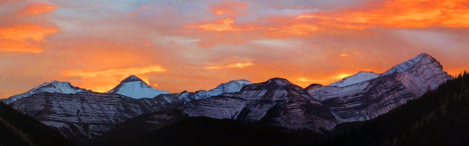
Sunset over Banded Peak as we drive home.
.jpg)
Panoramic tetrad sunset. Click to see larger. What a day!
.jpg)
.jpg)
.jpg)
.jpg)
.jpg)