Mount Ward
Elevation: 2530 m
Elevation Gain: 650 m
Part of the High Rock range, Mount Ward was named for Arthur Clitheroe Ward, commissioner of the British Boundary Commission in 1917. Its proximity to Window Mountain makes Mount Ward highly visible from Highway 3.
My Ascents:
September 9 2012
Trailhead: Window Mountain Lake Parking
The weather forecast for the Canadian Rockies looked downright miserable from Kananaskis through to Jasper on this day, however, the Crowsnest Pass region appeared to have been spared the snow expected in the main ranges. Unable to convince anyone else to invest in a 3 hour drive to bag a small peak in the front ranges, I set off on my own. It had been a while since I attempted a solo scramble and I must admit that I missed the experience somewhat. I love being able to push myself with regards to pace and there’s something truly invigorating about stopping for a moment and being consumed by silence (except for the beating of your own heart). This being the Crownest Pass region, of course, the silence was eventually shattered by the noise of ATV marauding about the valley. Regardless, all was quiet when I started the scramble!
.jpg)
View of Mount Ward (right) and Window Mountain (left) from the approach up the rough Allison Creek forestry road. I HATE this road. It seems to me that a province as wealthy as Alberta could pay to have this dirt road occasionally regarded, particularly given that there are many signed trailheads/hiking areas, presumably designed to draw tourists to the area. Even if the government won’t pay, it seems to me that Devon does an awful lot of work in the area. Any Devon employees reading this: think of the good PR and community relations that could be gained by paying to have the road graded!
.jpg)
After driving up the Allison Creek road for ~17 km, I turned left onto a ROUGHER road and followed it for 1.3 km where I saw this sign and was relieved to finally park my car and not have to cause any more damage to my poor suspension! Driving along these damned forestry roads is BY FAR the most stressful part of this scramble! Perhaps the bears in this area wouldn't be so easily enraged if the roads got fixed up a little?
.jpg)
The parking area and the rough road that was not, in all likelihood, ever intended to be driven with a Honda Accord. Only bottomed out 3 times!
.jpg)
After about 20 minutes at a brisk pace, I came upon the marshy area that Kane described. The trail was easy to follow with bright orange "hiker" signs marking the way along various old logging roads. Ward Mountain is the peak immediately behind.
.jpg)
Only moments after tramping past the marsh, I came upon Window Mountain Lake. Here, Mount Ward is reflected in its still waters. The ascent route aims for the valley at the back of the lake. Although Kane recommends circling around the lake on the right, both sides looked passable to me. I nevertheless, stuck with Kane's advice.
.jpg)
Looking back at the lake. Circling around the side of the lake that Kane recommends (left from this vantage) involves crossing numerous berry patches, including one VERY thick one at the end of the lake. Good thing bears don't hang out in spots like that...
.jpg)
That’s a LOT of scree. Joy! I ended up ascending near the back of the cirque in an attempt to stay on grass for as long as possible but I don’t think it really makes much of a difference how you get to the summit from here. Loads of nasty, ankle-rolling scree every which way.
.jpg)
Improving views of Window Mountain Lake justify a photo and a breather!
.jpg)
I ended up gaining the summit ridge on the climber’s right of the peak and having to scramble up this ridgeline. The scrambling was easy and the views over the ridge pleasant.
.jpg)
Seven Sisters Mountain, Mount Crowsnest and Window Mountain highlight the view from the summit ridge. Much more scenic than the endless views of scree from lower down! Click to see larger.
.jpg)
Group summit shot. From left to right: me.
.jpg)
Seven Sisters Mountain and Mount Crowsnest look great from any angle! The route up Crowsnest can be seen here.
.jpg)
Summit panorama to the south. Click to see larger.
.jpg)
The impressive window for which Window Mountain was named.
.jpg)
Enjoying the sunshine...while it lasts.
.jpg)
Window Mountain Lake from the top. Apparently the crown jewel of the Crowsnest hiking crown...
.jpg)
Like most things, I think that the lake looks better from the top.
.jpg)
Getting ready to row row row their boats back down at the lake.
.jpg)
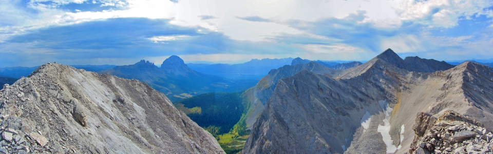
There are two summits only a one minute scramble apart. From the first, the second appears to be higher. From the second, the first appears to be higher. The register was on the first but I thought it prudent to bag them both anyways. The panorama to the west from the second summit was similar to that from the first (click for full size)! Allision Peak is the pointy mountain near the center and is scrambleable from Mount Ward. Perhaps next time…
.jpg)
The view to the west.
.jpg)
The considerably flatter view to the east!
.jpg)
Out of nowhere, a storm suddenly appeared over Allison Peak, prompting a sudden descent on my part! I was just as worried about having to drive my car down the rough forestry road in the mud as I was about lightning! Fortunately, despite its menacing appearance, only a few rain drops fell.
.jpg)
Things were a little more serene for those fishing at the lake.
.jpg)
.jpg)
.jpg)