Observation Peak
Elevation: 3174 m
Elevation Gain: 1100 m
Named in 1898 by C.L. Noyes for the fine view offered from its summit. Observation Peak was first ascended by Walter Wilcox and Bill Peyto in 1894. Peyto, not accustomed to mountaineering was apparently "overwhelmed with the magnificent panorama, and said that he now appreciated, as never before, the mania which impels men to climb mountains."
My Ascents:
August 26 2012, August 3 2008
Trailhead: Observation Peak Pullout
It’s been a busy summer for easy scrambles! With the addition of Crux to our family, I’ve been taking on a lot more of the “easy” ones since his paws don’t work so well for climbing! This is not a bad thing but it is making it more challenging to decide what to climb (Crux has already taken on a lot of the best “easy” ascents). After the mentally exhausting task of picking a worthwhile easy scramble that we hadn’t been up already, I finally settled on Observation Peak. Although I had climbed it several years earlier, I remembered the views being spectacular and hoped that the clear skies forecast would grant me a second chance to see them! Observation features two main gullies (a northerly and a more southerly) which can be used for ascent. If you follow Kane’s directions, just passed the sharp left turn in the gravel approach road, you will come upon a cairn and well-trodden trail. This leads to the more northerly gully and is, in my opinion, preferable. If you turn off of the gravel road too soon, you will end up in the more southerly gully and on more moderate terrain.
.jpg)
Early views of Peyto Lake from about half way up. Infinitely better than the view from the Peyto Lake observation platform a few hundred meters below!
.jpg)
“Why do you make me climb mountains?”
.jpg)
Aurore and Gord making their way up the steep scree. Mount Jimmy Simpson, Peyto Lake and Glacier and Caldron Peak beyond.
.jpg)
The ledges that allow you to surmount the mid-mountain rock bands proved a little more challenging for puppies. Here Crux is on the receiving end of some assistance.
.jpg)
Gord topping out on the false summit amidst a spectacular view. I had been hoping for clear skies (as always) but I think this is the most crystal clear sky I have ever scrambled under!
.jpg)
Aurore takes a breather after descending from the false summit (behind her). On to the true summit!
.jpg)
Gord making his way along the tame terrain between the false and true summit. The highest and third highest peaks in the southern Canadian Rockies (Mounts Assiniboine – far left and Temple – far right) tower in the distance. Kootenay giants Storm Mountain and Mount Ball in between and Bow Peak in the foreground.
.jpg)
The substantial glacier hanging from the east face of Observation Peak.
.jpg)
A large moraine allows a tarn to pool at the base of the steep icefall.
.jpg)
Beautiful cornices highlight the view to the south.
.jpg)
Looking north along the Icefields parkway from the summit. From left to right: Mount Mummery (distant), the Delta Glacier, Barbette Mountain, the Freshfield Icefield (distant), Mount Patterson, the Waputik Mountains, Mount Forbes (distant) White Pyramid, triangular Mount Chephren and flat-topped Mount Saskatchewan.
.jpg)
White Pyramid (left) and Mount Chephren (right) provide sharp bookends to massive Mount Columbia in the distance. Mount Columbia is the second highest peak in the Canadian Rockies and is over 80 km to the north from Observation Peak.
.jpg)
Peyto Lake below Caldron Peak. Mistaya and Barbette Mountains to the right with Mount Mummery in the distance. To the left of Caldron Peak, Mount Baker (distant snowy pyramid) and Mounts Rhondda and Collie at the top of the Peyto Glacier.
.jpg)
Peyto Peak high above Caldron Lake across the valley.
.jpg)
The Peyto Glacier spills down from Mounts Thompson (left), Rhondda (center) and Baker (right).
.jpg)
BIG scenery, little Matt.
.jpg)
Heavily glaciated Mount Mummery.
.jpg)
Looking south towards Bow Lake. From left to right: Crowfoot Mountain, Cathedral Mountain (distant), the Goodsirs (distant and huge), Mount Balfour, Mount Olive, Mount Gordon and St. Nicholas Peak.
.jpg)
The Bow Glacier. Mount Olive to the left and massive Mount Gordon behind and to the right. Tiny (from here anyways) and pointy St. Nicholas Peak in the middle.
.jpg)
The Crowfoot Glacier high above Bow Lake with a flurry of distant peaks visible.
.jpg)
A closer view of the crevasses and seracs making up the Crowfoot Glacier.
.jpg)
Distant Mounts Victoria (left) and Biddle (right) beyond the Crowfoot Glacier.
.jpg)
The skies were so clear that we could easily see the three highest peaks in the Southern Canadian Rockies. Here the second highest peak in the southern Canadian Rockies, Mount Goodsir is visible in the distance beyond Mount Balfour.
.jpg)
Incredible glaciation on the east face of Mount Balfour.
.jpg)
Puppy panorama.
.jpg)
Puppy love.
.jpg)
The Dolomites and Cirque Peak dwarfed by 11,000ers Mount Hector (left ) and Assiniboine (right – distant) to the south.
.jpg)
Three generations of Hobbs’ in front of the northern panorama. From left to right: Mount Chephren, Mount Sarbach, Mount Saskatchewan (distant glaciated), Tangle Ridge, Nigel Peak, Mount Coleman, Mount Murchison and Mount Weed.
.jpg)
The Wapta Icefield spills into Bow (left) and Peyto (right) Lakes on opposite sides of Bow Summit. To the left, the lake drains into the Bow River and to the right, into the Saskatchewan River.
.jpg)
Another peak bagged for the old man!
.jpg)
Peyto Lake and the tapestry of outwash streams at its head shimmer in the afternoon sunlight.
.jpg)
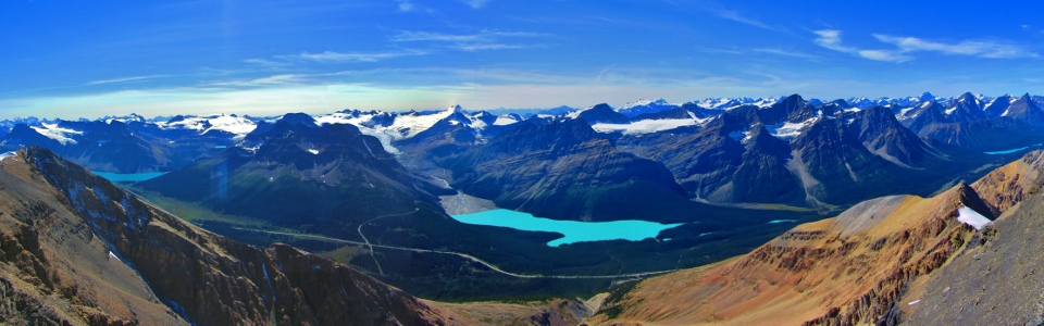
Icefields panorama. Click to view larger.
.jpg)
Mount Recondite points straight to the sky beyond a summit inuksuk and Mount Kentigren.
.jpg)
Group summit shot.
.jpg)
Group summit shot in which you can actually spot the group!
.jpg)
A small tarn collecting between the flank of Observation Peak and the cornice clinging to its east face.
.jpg)
A sea of remote peaks to the east. Click to see larger.
.jpg)
Playing in the cornice tarn.
.jpg)
Taking one last break to enjoy the view back at the false summit before commencing with the long scree ski down.
.jpg)
Aurore screeing down the more southerly of Observations two main gullies. Gord higher up on more moderate terrain. While it is possible to ascend and descend either of the two gullies, the more northerly of the two is preferable in my opinion. I’ll be sure to ascend and descend that one next time; and after a day like today, there will be a next time!
.jpg)
.jpg)