The Fist
Elevation: 2630 m
Elevation Gain: 750 m
Named for its resemblence to a clenched fist by Bernie Schiesser in 1973.
My Ascents:
September 1 2012
Trailhead: Commonwealth Creek Parking
Elevation: 2630 m
Elevation Gain: 750 m
Named for its resemblence to a clenched fist by Bernie Schiesser in 1973.
My Ascents:
September 1 2012
Trailhead: Commonwealth Creek Parking
Based upon an overly optimistic forecast for Saturday of the September long weekend, Mike and I had originally planned to attempt Mount Whymper in Kootenay. As Saturday morning drew near, however, the forecast for the Kootenay area had changed to include delights such as snow and lightning. As we started our drive westward, even the low peaks were enveloped in cloud, prompting us to make a last minute change to our objective. Reasoning that the weather might be better in the Spray Lakes corridor, we set our sets on a slightly smaller objective, the Fist. Neither Mike nor myself had ever successfully completed a scramble bearing a difficult rating, so it was with a little trepidation that we set out. As we approached the trailhead, the skies began to clear and we felt assured that we had made the correct decision, regardless of the difficulty rating.
.jpg)
Two of the seven moose that we saw on this day!
.jpg)
After about 20 minutes on the approach trail, we were tempted by this well-marked side trail. It’s a good thing that we didn’t follow it; it leads to a tarn below the un-scramble-able face of the Fist. If you’re attempting the Fist, stay on the main trail.
.jpg)
The noisy creek that Kane describes.
.jpg)
Our first view of our objective, the Fist, on the right. Impressive Mount Smuts to the left. The normal route ascends the Smuts – Fist col before climbing the back of the Fist.
.jpg)
Beautiful alpine meadows and stream in the valley between Mount Birdwood (pictured here) and the Fist. Moments after I took this photo, a panicked-looking hiker raced back down the trail towards us. He had, apparently, just been bluff-charged by a large grizzly 10 minutes further down the trail. Armed with this information, we were forced to decide whether or not to continue with our ascent of the Fist.
.jpg)
Reasoning that the grizzly was ahead of us, we decided to attempt to gain the proper route by ascending a different, closer avalanche gully. This decision kept us clear of the bear but forced us into some truly nasty bush-whacking. Here Mike questions his decision to wear shorts.
.jpg)
Higher up, he brush cleared a little and wildflowers become the dominant flora. The impressive face of the Fist lies straight above.
.jpg)
Beautiful views of Mount Birdwood across the valley as we gain elevation.
.jpg)
Going up an alternate avalanche chute forced us to side-hill along steep scree to gain the proper route. Unpleasant but preferable to an encounter with a grizzly!
.jpg)
Finally back en route at the Fist – Smuts col. From here, the route ascends the dark gully to the left of the large rock fin in the center of the photo.
.jpg)
Threatening clouds begin to loom over Smuts. At one point, it got quite dark and began to hail lightly. Fortunately, it blew over quickly!
.jpg)
Mike wiggling his way up the steep gully. Great scrambling in here though I would hate to run into a crowd in this steep, loose bottleneck.
.jpg)
A lateral traverse across steep slab covered by small loose rocks was one of the more challenging parts of the ascent.
.jpg)
The first of the two possible routes: straight up the gully to a skyline notch. We opted for this route and found it to be quite enjoyable.
.jpg)
The second of the two possible routes: a 2 m climb to the (climber’s) left followed by ascent of a wider gully. This route also looked quite do-able but there was really no need to avoid the notch and ledges of the first route.
.jpg)
The view from the skyline notch. Whereas other “notches” described in Kane’s guide are terrifying chasms that must be hopped, this one was nothing of the sort.
.jpg)
Mike making his way up to the notch.
.jpg)
Here’s where the scrambling gets really interesting! A fall to the (climber’s) right would be fatal, however, the holds were excellent and the exposure only lasted for about a dozen feet. After the short exposed bit, there are no further difficulties reaching the top!
.jpg)
We need to come up with new summit poses.
.jpg)
Mike on top.
.jpg)
Matt likes it on top.
.jpg)
Signing the soggy register: “First difficult scramble!”
.jpg)
Spray Lake from the top. Mount Nestor on the left, Mount Buller on the right. Mount Lougheed is prominent in the distance.
.jpg)
Success!
.jpg)
Cegnfs and Mount Murray to the left beyond Commonwealth Peak.
.jpg)
Looking back to the daunting Mount Smuts: largely considered to be the most difficult ascent in Kane’s guide.
.jpg)
Mounts Vavasour and Warre to the west through the Smuts – Birdwood col.
.jpg)
Looking across the Spray Lakes highway to Mount Engadine, the Tower (holder of my missing wallet) and Mount Galatea (shady).
.jpg)
Someday I’ll go back up the Tower to find my wallet. I think there was even a GST check in there.
.jpg)
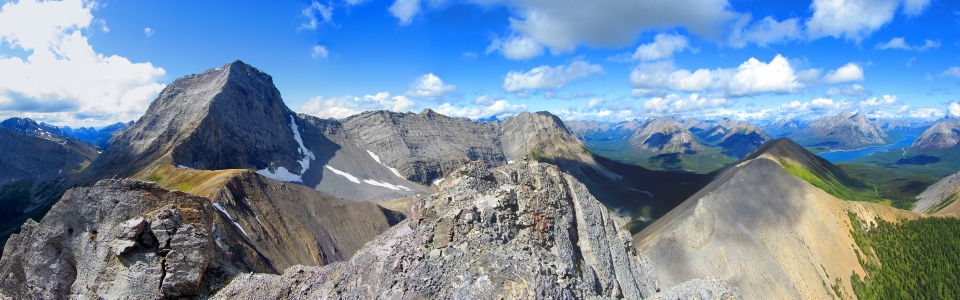
Fist-pumping panorama. Click to view larger.
.jpg)
What goes up, must come down…
.jpg)
Mike carefully descends the rubble-strewn ledges above a precipitous drop.
.jpg)
Back down at the notch, Mike catches his breath. From here on down, the trip was uneventful. Lots more bushwhacking and many “Yo Bears!” later we arrived back at the trailhead.
.jpg)
Our reward for getting down safely.
.jpg)
The seventh moose of the day - and it wasn't even a Tuesday!.