Waterton is very quickly becoming my favorite shoulder season destination! While the peaks closer to Calgary continue to be covered by snow, many of the larger Waterton peaks have started to come into form. I’ve always loved Waterton and, now that I’ve come to value the peace and tranquility that comes with having a peak all to yourself, this quiet little gem of a national park is even more special to me. Growing up, I have fond memories of completing all the classic Waterton hikes with my parents: the Carthew-Alderson trail, Crypt Lake and, of course, Bertha Lake. I distinctly remember being amazed by the sheer size of upper Bertha Falls and enjoying a cool swim on a hot day in Bertha Lake (well away from the outlet which leads to said falls, mind you). As an adult, when I picked up my first copy of “Scrambles in the Canadian Rockies”, I remember seeing Bertha Peak amongst the book’s many worthy scrambles and thinking that I had to revisit this place! I’m not sure why, but it took me several years to finally get around to it. Luckily, once I finally did, I was able to convince Brianne to join me for the long drive south and we were able to share this stunning peak together! Bertha was well-worth the wait!
.jpg)
Another beautiful day in Waterton! Summer seems to have arrived early in the south-west corner of our province as paint-brushes and other wildflowers littered the sides of the Bertha Lake hiking trail.
.jpg)
Although the hiking trail was quite crowded lower down, the masses seemed generally content to hike to lower Bertha Falls and then turn around. While the lower falls are pretty, those who continue on higher are treated to much better!
.jpg)
Bertha Peak looks fairly formidable from the hiking trail below the lake!
.jpg)
Bertha Lake: every bit as pretty as I remembered it being!
.jpg)
Although, at some point in my distant past I swam here, it looked a little cold to me on this particular day. Crux, however, found the water just perfect and set about to retrieve any logs which happened to float by.
.jpg)
Auditioning to be a retriever…
.jpg)
What to do with his hard-earned log? Bury it of course! No, that’s not a sandy beach; these are the Canadian Rockies afterall!
.jpg)
The view of Bertha Peak from the lake. The Kane route involves going up amongst the ledges near the waterfalls in the center of the photo, however, we opted to use the (slightly) more gentle south-facing skyline ridge on the left for ascent. While it looks “gentle” in this photo, it’s quite steep until the dip in the terrain from which Kane’s waterfalls pour forth. Click to see more detail.
.jpg)
The trail around the north shore of the lake was buried in snow but we didn’t have to worry about any bushwhacking…because the trees were also buried in snow. The snow must have been several meters deep in places but, fortunately, it was solid and supportive and travel along top of it was easy.
.jpg)
Snow dunes. And yes, that is the top of a tree trying to poke through on the right.
.jpg)
Eventually, the snow gave way to the usual trail which rounds the north shore of the lake. At a high point on the lakeshore trail, the path splits. The left-hand fork (shown here) takes you down to the lake for a view, while the right-hand fork continues into denser forest along the lake. This is where we left both trails behind and took advantage of open grass slopes to start our ascent.
.jpg)
Looking up our ascent slope from the same point as the previous photo. The path on the right returns from whence we just came.
.jpg)
Typical terrain on the lower open slopes. The outcrops all angle towards the climber’s right leading to steeper terrain so we had to make a concerted effort to trend generally left whenever possible. Routefinding was really a non-issue since the scrambling possibilities were many!
.jpg)
Brianne and Crux enjoying some “hands”-on scrambling as the lake retreats further and further below us.
.jpg)
The steepness of the ascent slope and the spectacular views resulted in frequent “photo” stops. Here Lower Waterton Lake comes into view below Vimy Peak (background) and Bertha Lake (foreground).
.jpg)
Brianne making her way up to the bump on the left. From there, we’ll have to descend slightly to the right in order to start our ascent of the actual summit (shown on the far right here). Kane’s waterfall route would bring you up to the dip between the two peaks shown here.
.jpg)
Waterton’s trademark colorful argillites become more prominent the higher that you go.
.jpg)
Brianne slogs away while I enjoy the spectacular view of semi-frozen Bertha Lake nestled in at the base of Mount Richards.
.jpg)
Panorama from the top of the first “bump”. Like it had along the lakeshore, the terrain here trapped the snow and we, once again, found ourselves walking past the tops of buried trees. As you can see, gentle slopes on the left lead to the summit. Click to see larger.
.jpg)
Crux wondering what happened to the bottoms of all those trees.
.jpg)
Perhaps, it was heat stroke and perhaps it was just exhaustion but I couldn’t stop laughing while looking at the little rings around all of the trees. Maybe I should have stayed more well-hydrated on the way up!
.jpg)
Past the small SNOWY dip where I route and Kane’s intersect, the remainder of the ascent was an easy plod.
.jpg)
Brianne continues to plod, refusing to be distracted by the amazing view of Mount Cleveland.
.jpg)
This is my idea of a beach vacation!
.jpg)
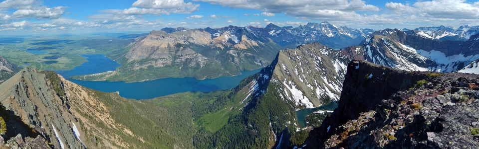
5 hours after leaving the car, we topped out on the summit and were treated to this, one of my favorite summit panoramas to date! Click to see larger.
.jpg)
Massive falls drain Bertha Lake (bottom right) into Upper Waterton Lake. Across the lake, the yellow rocks of Mount Boswell provide a splash of color while the tallest peak in the area, Mount Cleveland, dominates the skyline.
.jpg)
Bertha Lake and upper Bertha Falls.
.jpg)
The mountains abruptly give way to the prairies beyond Vimy Peak across Waterton Lake.
.jpg)
Crux enjoying a well-earned break.
.jpg)
Nearby Mount Alderson dominates the colorful and snowy panorama to the west. Click to see larger.
.jpg)
Mount Alderson (left), Mount Carthew (center) and Buchanan Peak (right) in the late afternoon sun.
.jpg)
One of the still-frozen Carthew Lakes nestled in at the base of its namesake peak. The popular Carthew-Alderson trial makes its way over the pass behind the lake. Massive Kinnerly Peak makes an appearance in Glacier National Park to the south.
.jpg)
A small sea of peaks to the north including (from left to right): Mount Blakiston, Ruby Ridge, Mount Glendowan, Cloudy Peak, Mount Dungarvan, Mount Galwey and Mount Crandell.
.jpg)
A good view of Mount Crandell’s technical ascent routes.
.jpg)
Red and yellow rocks of Mounts Lineham (left) and Blakiston (right) provide a colorful backdrop to lush green valleys below.
.jpg)
The ascent slopes of Mount Blakiston (the tallest peak in Waterton National Park) appear to be rounding into form. Mount Hawkins to the left and beautiful Ruby Ridge below.
.jpg)
The Boss and her scrambling baby.
.jpg)
Mount Cleveland beyond the red argillite on the northeast ridge of Mount Richards. The southern tip of Waterton Lake visible below.
.jpg)
An impressive perspective on Mount Cleveland’s north face.
.jpg)
The obligatory telephoto shot of “more impressive peaks to the south”.
.jpg)
Ditto.
.jpg)
Lower (left) and Upper (right) Waterton Lakes connected by the shallow Bosphorus straight.
.jpg)
Mount Boswell across the lake. The Crypt Lake hike makes its way up the valley on the left.
.jpg)
Hyper-zoom on Chief Mountain to the east – guess I need more megapixels to get a good shot of this peak from Bertha!
.jpg)
Groups summit photo before heading down. Crux was kicked out of the photo for not cooperating (he, apparently, didn’t want to sit on the edge of a cliff like we did to get the “perfect picture”).
.jpg)
Starting the long descent of red scree.
.jpg)
Crux is all about the glissade.
.jpg)
Come back?
.jpg)
We did eventually catch up to our dog at the bottom of the snow slope.
.jpg)
While we were at the summit, the ice sheets on Bertha Lake decided to rearrange themselves. The lake itself and Mount Richards were still in the same place though.
.jpg)
Rather than retrace our own ascent steps, we aimed towards more open terrain on the skier’s right. While the slopes were steep, they proved an efficient way to lose elevation!
.jpg)
Checking out the waterfall at the back of Bertha Lake from afar. The light beginning to fade…
.jpg)
Although our “more open” descent slopes would lead to forest before we could reach the trail that rounds Bertha Lake, we aimed for an avalanche gully in the hopes that violent avalanches would have cleared a path through the trees for us. For the most part it worked and we even got a small glissade in for good measure!
.jpg)
Back on the path and enjoying the carpet of glacial lilies around the lake.
.jpg)
Summer is here; the bear grass is flowering!
.jpg)
.jpg)
.jpg)
.jpg)