During the bleak winter months, I remember spending hours “escaping” the snow and ice reading scrambling trip reports online (never while at work though, I swear). During this time, I stumbled across a number of more remote peaks that didn’t make the cut in Kane’s guide and these were quickly added to my ever-expanding to-do list. Funny, at the rate that I scramble, you’d think that the list would be dwindling, not growing. I remember being impressed by the rock walls of Black Rock Mountain as I read Vern Dewit’s trip report and thinking that this peak, with its unusual location well-east of the front ranges would make a great early season outing in an area that I had, until now, neglected. Fast-forward a couple of months and early season is here! Since it was father’s day, I convinced Gord to join me (which was very fortunate since his 4x4 proved indispensable) and he, in turn, convinced my mom to join us. And so, we set off (in Gord’s 4x4) on what my mother would frequently (and somewhat sarcastically) refer to as “an adventure”.
.jpg)
After 16 km on the very rough "Transalta" dirt road (it took us almost an hour to cover that distance in a 4x4), we arrived at this sign which warned us that the road ahead (down the hill and to the gravel flats below) was “not recommended for vehicle traffic”. Knowing that if we parked here, we would add 4 km to our approach, we reluctantly opted to continue down the road with Gord growing ever more concerned about his suspension.
.jpg)
At the bottom of the hill (which, quite rightly, was not suitable for vehicle traffic), we realized that in order to continue in the truck, we would have to drive through the river. Initially, we parked and decided to hike the remainder of the approach on foot. As you can see from the photo, Black Rock Mountain is still a good distance from here. Fortunately, by the time we’d gotten our boots on, another (smaller) 4x4 drove across the river while we watched. Buoyed by the fact that “he made it across”, we decided to get back in the truck and to see if we couldn’t shave some more mileage off of our approach. I’m happy to report that we did. Oddly enough, the river crossing and subsequent 4 km drive to the “trailhead” were significantly smoother than the initial 16 km drive on a rough, ridiculously pot-holed road.
.jpg)
A short time after the road (and the river it parallels) turned to the west, we found this cairn near the base of Black Rock Mountain and parked here.
.jpg)
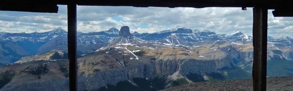
My parents enjoying the view of the Devil’s Head from the trailhead.
.jpg)
With part 1 of our “adventure” (the drive in on the very rough road) complete, we embarked upon part 2. Fording the river 5 minutes beyond the trailhead. Crux showed my mom the best way across and the 2 of them had an easy go of the crossing (she was smart enough to bring sandals). Gord and I, on the other hand, stumbled our way across the freezing water bare foot. To make the freezing ford even more fun, the collapsible hiking pole that I was using for balance did just that; it collapsed, nearly sending me tumbling down for an icy bath. Alas, all’s well that ends well and we all made it across unscathed.
.jpg)
Phantom Crag is an impressive peak back on the other side of the river.
.jpg)
Believe it or not fellow Albertans, this sign is supposed to mark the start of the Black Rock Mountain trail on the opposite bank of the river so that hikers will know where to cross; it is not (nor was it ever) supposed to be used to shoot your guns at. Sigh. #bulletholes.
.jpg)
Shortly after fording the river and finding the target sign, there are some “stairs” carved into a steep dirt hill side. Once you’re up these stairs, you find yourself on the very wide and pleasant former packhorse trail.
.jpg)
Typical going on an excellent trail below the tree line.
.jpg)
Breaking the tree line, you’re confronted by rather intimidating sheer cliff walls. Before you question your decision to continue up this peak, remember: pack horses used to do this.
.jpg)
Despite the intimidating cliffs, the trail gently contours around the mountain, eventually reaching a break through which an excellent trail leads. Despite the challenging appearance of the terrain, it’s all hands-in-pocket walking!
.jpg)
The route brings you alongside some very cool-looking rock formations and more than a few large fissures that make you wonder exactly how stable this whole mountain really is.
.jpg)
Looking back to the west through the gap. Great views, especially for the front ranges!
.jpg)
Mount Aylmer’s snowy form shimmers in the sun.
.jpg)
Crux investigates a fissure.
.jpg)
Gord and my mom easily make their way through the gap in the cliffs on their way to Black Rock Mountain’s upper penultimate plateau.
.jpg)
Up on the broad sub-summit plateau and enjoying the view south past Phantom Crag to Orient Point (left) and Saddle Peak (right).
.jpg)
From the plateau, we could finally see the summit (and accompanying lookout). My mom was rather disheartened to discover that the plateau was not actually the summit and that said summit still stood a significant vertical distance above us.
.jpg)
Crux makes his way up the rubble towards the summit. The scree was, generally, not as bad as it looked on ascent.
.jpg)
Near the very top, the exposure starts to close in from both sides. Still, the path up is wonderful and, at no point, does one need to resort to any “hands-on” scrambling.
.jpg)
Gord makes his way up the final, mildly exposed ridge to the summit with Phantom Crag and Mount Costigan behind. I say “mildly exposed” because there are, in fact, sheer drops to both sides of this ridge, however, the ridge itself is wide, solid, flat and pleasant. If anything the exposure adds to the sense of accomplishment without really making said accomplishment any more challenging!
.jpg)
Crux and I enjoy the same view that fire lookouts did some 60 years ago.
.jpg)
The view from the lookout. From left to right: Mount Aylmer, the Devil’s Head, Astral Peak and Mount Davidson.
.jpg)
My “little” devil and the Devil’s Head.
.jpg)
Black Rock summit panorama showing the odd separation between Black Rock Mountain and the rest of the front ranges to the west. Click to see larger.
.jpg)
The Ghost River winds its way along the base of impressive Mount Costigan.
.jpg)
Telephoto of the Fairholme Range, possibly Mount Charles Stewart.
.jpg)
In the distant south, the sun shines on Fisher Peak beyond Phantom Crag and Orient Point.
.jpg)
Distant Kananaskis giants to the south: Mount Bogart, Wind Mountain, Lougheed III, Mount Sparrowhawk, Mount Lougheed and Lougheed I.
.jpg)
A small, but impressive, eastern outlier of Mount Davidson to the north.
.jpg)
Summit family photo minus one mountain-climbing canine.
.jpg)
Wishing the old man a happy father’s day!
.jpg)
Prairie panorama of the Ghost-Waiparous area to the east. Ghost river to the right. Click to see larger.
.jpg)
Calgary in the distance. Hey, I think I see Brianne drinking my beer!
.jpg)
One last family photo (with everyone this time – even if one of us was pointing the wrong way) before heading back down.
.jpg)
Down the steep scree. My mom had been a little stressed out about descending this steep section but now that we’re back down on the broad sub-summit plateau she’s all smiles and very proud of her most recent peak-bagging accomplishment. Don’t tell her but we’re proud of her too! ;)
.jpg)
The start of a rather large fissure that appeared to run the length of Black Rock mountain from east (shown here) to west.
.jpg)
Peering down into the depths of the fissure. At this point, we couldn’t see the bottom of it…
.jpg)
Crux and I hopped the fissure to check out the impressive south-facing cliffs of Black Rock from above.
.jpg)
Like I said, impressive cliffs!
.jpg)
My mom making her way down the surprisingly easy trail through said cliffs.
.jpg)
I think he had a happy father’s day!
.jpg)
I think she did too! With views like this of Mount Costigan, who wouldn’t?
.jpg)
Back down, back across the freezing river and back at the trailhead looking back to beautiful Black Rock Mountain.
.jpg)
A lonely little lookout perched atop some very impressive cliffs.
.jpg)
Back in the truck and getting ready to ford the Ghost River for the fourth and last time of the day!
.jpg)
Some very cool lighting on Pigeon Mountain and the Bow Valley as we drive back towards Calgary after a thoroughly pleasant “adventure”.
.jpg)
.jpg)