With reasonably awful weather forecast for the entire weekend, I decided to settle for a smaller objective which could (hopefully) be summited before afternoon thunderstorms chased me down. Upon discovering that Highway 40 was finally open all the way to Highwood Pass for the first time since June’s floods, I decided to pay a visit to that area for the first time this year to take advantage of the relatively high starting elevation (2206 m). Since I had Crux in tow, I wanted to avoid the area’s moderate and difficult scrambles in favor of some less technical and more puppy-friendly hiking. The ascent of Grizzly Ridge, with the possibility of a traverse to Highwood Ridge, was particularly appealing as it would allow me to claim 2 summits (albeit small ones) and hopefully be back down before the worst of the weather hit.
.jpg)
Only 10 feet from the parking lot: the scenery at Highwood Pass is already spectacular. As you can see, the weather was perfect early on. This area is a real gem – many thanks to the road crews who worked hard to reopen the highway to it!
.jpg)
I followed the well-trodden trail towards Grizzly Col and Pocaterra Ridge from the parking lot, making my way through the boggy forest and to this pleasant alpine tarn in about 30 minutes. As you make your way through the forest before this tarn, you’ll note several less well-used forks in the trail going left (uphill); these other paths provide a quick way up Highwood Ridge if you’re not aiming to do Grizzly Ridge as well.
.jpg)
A greeting committee blocks the trail just beyond the tarn. Crux was surprisingly well-behaved and on leash but they still didn’t seem to care for him (one of them started to put his head down in a display of aggression when he saw Crux). Not wanting to mess with them, Crux and I abandoned the trail and detoured into the larch forest for a short distance to get past them (they had NO interest in moving on). Once past the sheep, keep your eye out for the cairned fork in the trail beyond the tarn. Left takes you to Grizzly Col (Grizzly Ridge and Mount Tywhitt approach) and right takes you to Pocaterra Ridge.
.jpg)
As you can see from the large mud/rock slides, Grizzly Col was obviously affected by June’s floods.
.jpg)
Another hiker makes his way along the well-graded trail past the slides towards Grizzly Col. At present, the trail has been annihilated where the slides cross its path but it shouldn’t take long for hikers to bash a new trail into the loose scree littering the slide paths.
.jpg)
Once up to the col, the majority of the elevation gain is complete and the view of Mount Storelk and the Elk Range to the south provides a convenient excuse to pause for photos while you catch your breath.
.jpg)
Clouds brooding over the peaks of the Elk Range.
.jpg)
Looking back towards the ascent valley, Mount Pocaterra (left) and Pocaterra Ridge (right) from Grizzly Col. Click to see larger.
.jpg)
Elpoca and Tombstone Mountains beyond the grassy slopes of Pocaterra Ridge.
.jpg)
From the col, you can see the summit of Grizzly Ridge on the left. The route follows a good trail through the scree on the right before gaining the ridge and following it to the high point.
.jpg)
Panorama showing Mount Tyrwhitt, Mount Pocaterra and Pocaterra Ridge from the ridge crest. Click to see larger.
.jpg)
A great view of the steep and loose ascent route for Mount Tyrwhitt (also ascended from Grizzly Col).
.jpg)
Looking along the rest of Grizzly Ridge to the summit (left). On the right is the jagged connecting ridge to Highwood Ridge with Mounts Rae (left in the clouds) and Mount Arethusa (right) beyond.
.jpg)
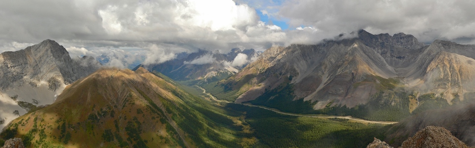
Panorama of Paradise Valley below the 4 km length of Highwood Ridge with the Misty Range (including Mount Arethusa, Storm Mountain and Mist Mountain) beyond. Click to see larger.
.jpg)
Increasing cloudiness atop Storm Mountain. As I approached the summit of Grizzly Ridge, the clouds from the Kananaskis Lakes Valley below began to lift, filling Highwood Pass.
.jpg)
Inclement weather begins to overtake the Misty Range (left) and the Elk Range (right). When bad weather comes from both sides, it’s rarely a good sign! Click to see larger.
.jpg)
At the summit, wisps of cloud moved quickly by – the view changed by the second.
.jpg)
Crux pauses to celebrate a milestone – his 30th different summit in the Canadian Rockies! Good boy! ;)
.jpg)
Paradise Valley and a sea of peaks to the southeast along the still-closed section of Highway 40 which connects to Longview.
.jpg)
Highwood Pass panorama. From left to right: Mount Pocaterra, Mount Roberta, Mount Kent (distant through the clouds), Pocaterra Ridge, Gap Mountain (behind the clouds), Elpoca Mountain, Tombstone Mountain, Mount Rae, Mount Arethusa and Little Arethusa. Click to see larger.
.jpg)
Mount Rae and Ptarmigan Cirque across the highway.
.jpg)
Clouds obscure parts of the connecting ridge to Highwood Ridge. Although the ridge looked like it might get a little scrambly for Crux, a trip report from Bob Spirko indicated that all difficulties could be by-passed on the right hand side. What I didn’t bank on was how FAR right I would end up having to go! Still, it wasn’t raining and there was no thunder so I decided to proceed and attempt the two’fer.
.jpg)
Making my way along the connecting ridge. Unfortunately, shortly after this photo was taken, the terrain got a little too hands-on for Crux and I had to make my way down steep scree on the right. The right-hand slope is steeper than it looks and because of the angle which the rock strata cut through the hillside, it’s more difficult to regain the ridge once you’re down that it appears like it will be from above! I ended up side-hilling on loose steep scree for much longer than intended before finding an easy place to regain the ridge.
.jpg)
Looking back, my dark track through the side-hill scree is obvious. I ended up side-hill bashing until gentler grassy slopes on the far side of the Highwood Ridge summit provided an easy walk to the top.
.jpg)
Crux picks his way back towards the summit on more pleasant terrain.
.jpg)
At the summit, the view of Mount Pocaterra, Pocaterra Ridge and the tarn that I passed earlier was somewhat spoiled by the cloud which, incidentally, had begun to produce rain and some rumbling thunder; I didn’t linger for long!
.jpg)
Storm Mountain disappearing and reappearing in the cloud.
.jpg)
Highwood Ridge on the left and Grizzly Ridge on the right. Why is the forecast only right when it calls for bad weather? Click to see larger.
.jpg)
Realizing that I didn’t have a single photo of myself, I snapped a quick “selfie” before descending to the warm, dry car below!
.jpg)
Rather than retrace my steps along the scrambly ridge in inclement weather, I opted to descend the north ridge which provides a much quicker route back to the parking lot. The descent was easy and there was even a trail and cairns for most of it. Once back in the woods, the trail splits in a few places but all of these paths eventually seem to lead back to the larger path that I used earlier on approach. The north ridge could also be used for a more direct and easier way to ascend Highwood Ridge.
.jpg)
Looking back at the high points of Highwood Ridge (left) and Grizzly Ridge (right) and the cool rock strata in between. Click to see larger.
.jpg)
After racing the weather all day and not stopping for food or water, a pleasant alpine meadow half way down the north ridge provided a good chance to finally stop for lunch. From lower down, the view was somewhat improved despite the continued rain. Click to see larger.
.jpg)
Crux eyeing my sandwich…
.jpg)
Although I’ll always pick a sunny bluebird day over a rainy one, the clouds have a way of making the peaks (like Storm Mountain here) look more intimidating.
.jpg)
Back down at the Highwood Pass parking area – Mist Mountain lives up to its billing!
.jpg)
.jpg)
.jpg)
.jpg)
.jpg)
.jpg)
.jpg)
.jpg)