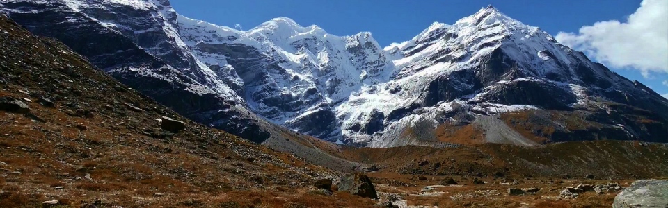
Mera Peak Trek
Elevations: Kathmandu: 1400 m, Lukla: 2840 m, Chutanga: 3450 m, Zawtra La: 4610 m, Zawtra: 4300 m, Kothe: 3691 m, Tangnag: 4356 m, Khare: 5000 m.
Total Distance: 84 km (round trip).
Our Ascent:
October 1 - 10, 2013.
Elevations: Kathmandu: 1400 m, Lukla: 2840 m, Chutanga: 3450 m, Zawtra La: 4610 m, Zawtra: 4300 m, Kothe: 3691 m, Tangnag: 4356 m, Khare: 5000 m.
Total Distance: 84 km (round trip).
Our Ascent:
October 1 - 10, 2013.
Regardless of where they live, every mountain lover on Earth dreams of being able to visit the Himalayas to see the top of the world up close and in person. I am, of course, no different. Several years ago, some friends of mine visited Nepal, undertaking the popular trek to Everest Base Camp and even bagging a small (5643 m!) peak while there. When they returned, I spent hours poring over their photos which beautifully showcased the spectacularly jagged and glacier covered peaks of the Khumbu region. Reliving their trek vicariously through their photos, I was extremely envious and filled with a deep longing to visit the highest peaks in the world myself.
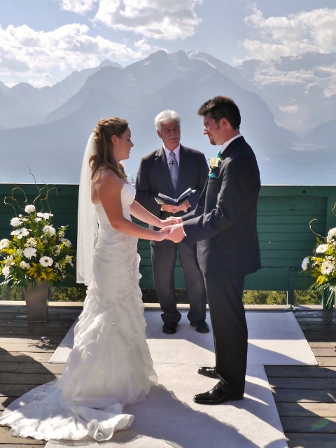
In the years that followed, I graduated, found a job and settled into a routine of scrambling every peak that caught my fancy in the Canadian Rockies; the dream of visiting Nepal began to grow distant in my mind. During this period of “growing up” and intense peak bagging, I was lucky enough to find the love of my life Brianne who, on August 3 2012, said “yes” when I asked for her hand in marriage. On September 14 of the following year, we were married amongst family, friends and glaciated summits in beautiful Lake Louise, Alberta near our home.
As everyone knows, a wedding must be followed by a honeymoon! While many would be happy to lie together on a tropical beach, Brianne and I wanted our honeymoon to be the trip of a lifetime; and so the idea of travelling to Nepal crept back into the forefront of both of our minds. While there would have been no shame in repeating the scenic Everest Base Camp trek undertaken years earlier by my friends, I felt compelled to try something new – something more adventurous – and the peak bagger in me yearned for a summit in the world’s greatest mountain range. Much research was undertaken and I was rapidly seduced by the idea of attempting to climb Mera Peak (6461 m). I initially broached the subject of climbing Mera with Brianne in an e-mail. Her response was less enthusiastic than I had hoped for: “No. That mountain is too big. I don’t think WE could climb it even if WE wanted to.” Fortunately, I’m both persistent and persuasive. Eventually, she agreed that we might be able to make it (although deep inside, I don’t think she ever actually thought that she would be able to). And so, arrangements were made with a local trekking and expedition company (Langtang Ri) and flights were booked!
What follows is more than just a trip report like the many others that I post on this site. What follows is the story of our Himalayan honeymoon on top of the world!
.jpg)
We arrived in Kathmandu, absolutely exhausted, at 10:00 pm on Monday after leaving our home at 10:00 am…on Sunday. The culture shock was sharp. We spent the following day exploring, trying to adjust and making final preparations for our trek.
.jpg)
Exploring the crowded and narrow streets in the Thamel district of Kathmandu near our hotel. The truly surprising thing about this photo is that almost everyone who should be wearing a helmet is wearing a helmet!
.jpg)
A brightly colored Hindu God contributes to the beauty of Basantapur Square in Kathmandu.
.jpg)
While the temples in Kathmandu were beautiful, most streets were reasonably filthy. The duelling odors of incense and human urine were difficult to reconcile and all about car horns blared; a sense of general chaos results.
.jpg)
Crossing one of several rivers in Kathmandu. As you can see, the banks are primarily made up of garbage. And yes, those are people bathing in the putrid water. Note to self: don’t drink the tap water.
Like many treks in the region (including the trek to Mount Everest Basecamp), the trek to Mera Peak generally begins and ends in the mountain village of Lukla, home to, what is often referred to as: the most dangerous airport in the world. The Tenzing-Hillary airport makes Lukla the gateway to the Himalayas for sightseers, trekkers and mountaineers alike. Although longer approaches (which provide more time for acclimitization) are possible, we adhered to the following popular itinerary (see interactive map below):
• Day 1: Arrive in Lukla (2840 m); stay overnight in a local lodge.
• Day 2: Trek to Chutanga (3450 m);stay overnight in a local tea house.
• Day 3: Ascend to and cross Zawtra La (4610 m) before descending to Zawtra (4300 m); stay overnight in a local tea house.
• Day 4: Descend to Kothe (3691 m); stay overnight in a local tea house.
• Day 5: Trek to Tangnag (4356 m); stay overnight in a local tea house.
• Day 6: Acclimatization hike to Sabo Tsho Lake; remain at Tangnag tea house overnight.
• Day 7: Trek to Khare (5000 m); stay overnight in a local tea house.
• Day 8: Rest/acclimatization day in Khare; remain at Khare tea house overnight.
• Day 9: Trek over the Mera Glacier, past Mera La (5415 m) and on to Mera High Camp (5780 m); stay overnight in a tent.
• Day 10: Summit (6461 m) attempt followed by return to Khare (5000 m); stay overnight in a local tea house.
• Day 11: Descend to Kothe (3691 m); stay overnight in a local tea house.
• Day 12: Trek to Zawtra (4300 m); stay overnight in a local tea house.
• Day 13: Ascend to and cross Zawtra La (4610 m) before descending to Lukla (2840 m); stay overnight a local lodge.
• Day 14: Free day in Lukla (or contingency day for poor weather).
• Day 15: Depart Lukla.
.jpg)
After bombarding our senses in Kathmandu, it was time to head back to the airport for our flight to Lukla. Flights to Lukla are notorious for cancellations due to mountain weather and we were alarmed to discover upon our arrival at the airport that no flights had left for Lukla during the previous 4 days. We crossed our fingers while others scurried to make alternate travel plans.
.jpg)
After a stress-filled 4 hour wait in the Kathmandu domestic airport terminal, our fears were alleviated when we learned that planes were able to land in Lukla today. A short time later, we found ourselves boarding our “state of the art” and “well maintained” Tara Air Twin Otter readying ourselves for our flight into the world’s most dangerous airport.
.jpg)
Not used to seeing these signs written in Sharpie on an airplane…
Any landing that you can walk away from is a good landing at Lukla and like the plane landing shortly after ours in this video, ours arrived safe and sound. The Lukla airport is regarded as the most dangerous in the world for several reasons: 1) The end of the runway (from which this photo was taken is a near vertical, heavily forested mountainside; 2) The other end of the runway is a very steep drop off; 3) The runway itself is very short (420 m) and is on a slope with a 12% gradient – pilots must therefore land “uphill”. These factors combine to make aborted landings and take-offs impossible.
.jpg)
Panorama of the lush and steep hillsides surrounding Lukla as seen from our room at the “Khumbu Resort”. Note the sloped runway on the left. We spent our first night here in an effort to give ourselves a better chance to acclimatize. After day 1, we would say "goodbye" to luxuries like toilets and showers. Click to see larger.
.jpg)
Passing by the hospital and its colorful gardens as we leave Lukla to embark on our trek. Although the Everest base camp trek and the Mera Peak trek both begin in Lukla, from there they set off in opposite directions; the Everest trek proceeds up the Khumbu valley while the Mera trek makes its way over Zawtra La (Pass) and then up the Hinku Valley immediately to the east.
.jpg)
As we made our way towards Chutanga, these children went about their daily trek (in the opposite direction) to school in Lukla.
.jpg)
One of many wet, rickety log bridge crossings to come. Here our climbing Sherpa Sarki keeps a close eye on Brianne.
.jpg)
Beautiful creeks cascading down the steep mountain terrain.
.jpg)
Looking back to Lukla through the mist as we gain elevation.
.jpg)
Typical terrain en route to Chutanga. The hike to Chutanga was fairly straightforward, taking us about 3.5 hours. By this point (around 11000 feet or 3300 m), however, we were beginning to notice how thin the air was; unfortunately, we still have over 10000 feet (3000 m) to ascend before reaching our final objective!
.jpg)
Wet weather greets us at our tea house in Chutanga. Unfortunately, that would become a bit of a recurring theme despite that fact that it was supposed to be dry season!
.jpg)
Fortunately, the woodstove in the common room was hot! At “low” elevations like this, wood is easy to come by. At subsequent higher stops, the woodstoves were more necessary but used much less frequently.
.jpg)
The facilities. These ones were actually very nice compared to some of the ones that we had the privilege of using as the trek went on.
.jpg)
Waterfalls in Chutanga. After hiking for only 3.5 hours, we had a lot of time to kill so Brianne and I wandered up the trail past these falls on an acclimatization hike to 3700 m. The next day, we would hike along this trail again, only the objective at that point (Zawtra La) would be much higher (4610 m).
.jpg)
The slopes above Chutanga littered with massive mossy boulders and cascading streams.
.jpg)
A massive boulder at 3700 m seemed like a good stopping point for our acclimatization hike as the warm woodstove in the dry teahouse below were calling to us!
.jpg)
After seeing very little through the mist the day prior, we awoke to a view of the grind that awaited us – the 1200 vertical meter ascent to Zawtra La. When we were researching this trek beforehand, many reports suggested that this day was the most difficult of the trek since it involved a lot of elevation gain without enough prior acclimatization. What these reports all failed to mention was that the pass that you can see from near Chutanga is not actually Zawtra La! The pass visible from here is actually lower than Zawtra La and once you reach it, you must still traverse high hillsides and gain about 100 m before actually crossing Zawtra La.
.jpg)
The standard view for the first couple hundred meters: mossy wet rhododendrons! Around 3800 m, we got a bit of a scare as Brianne couldn’t catch her breath and began to hyperventilate. After a 10 minute rest, however, we set back off at a slightly slower pace.
.jpg)
Once we were finally above the rhododendrons, we were granted a brief view of Chutanga below before the clouds swept up the valley swallowing up the views.
.jpg)
Our porter Lakba and our Sherpa Sarki lead the way up the steep but excellent trail towards Zawtra La.
.jpg)
Water courses down smooth slabs as the rain begins to pour down upon us for the second straight day.
.jpg)
A tea house provides a welcome break at 4000 m elevation as we ascend into the clouds. At the start of the trek, black tea was the tea of choice, however, as we started to get sick from days spent hiking in the rain, lemon tea proved to be the way to go! 600 m elevation gain down and 600 m to go before Zawtra La.
.jpg)
Himalayan heather lends some color to the otherwise bleak landscape.
.jpg)
Modeling the latest in mountain fashion: my “waterproof” (it wasn’t) poncho purchased for 500 NPR in Lukla. In an effort to cut down on weight, I had left my proper rain jacket in storage in Kathmandu. After all, it was supposed to be dry season…
.jpg)
Approaching the first pass (and what we originally thought was Zawtra La). The last several hundred vertical meters featured wonderfully constructed rock stairs (a new addition for the 2013 season). After ascending these wonderfully constructed stairs for 15 minutes, Brianne turned to me marvelling: "This almost looks man-made!" We'll go ahead and chalk that comment up to insufficient oxygen to the brain!
Not much to see from the first pass (not Zawtra La)...
.jpg)
At 4500 m, Brianne is excited because she thinks that the “up” is over for today. What neither of us realized is that this pass is not Zawtra La! Indeed, we still have another 100 m to gain to get to the necessary pass.
.jpg)
What followed the first nameless pass (I shall christen it the “Pass of False Hopes and Dashed Dreams”) was an hour of up and down side-hill traversing towards the real Zawtra La.
.jpg)
Finally at the real Zawtra La! Once again, a tea house was a welcome resting point as, by this point, our rapid ascent from 3400 m to 4610 m without sufficient acclimatization had begun to take its toll on me. Although I didn’t find the steep ascent particularly difficult, the last hour of traversing at elevation left me feeling generally “out of it”.
.jpg)
After enjoying some tea at the pass, we quickly descended 300 m to reach Zawtra (called Thuli Kharki on some maps), our final destination for the day, arriving some 5 – 6 hours after we left Chutanga.
.jpg)
Our room at the tea house in Zawtra didn’t seem to be up to North American building codes. Mind that first step!
.jpg)
One VERY wet yak.
.jpg)
Rain, rain go away!
.jpg)
After leaving Zawtra in the morning mist, we spent an hour traversing steep grassy terrain to yet another unnamed pass.
.jpg)
A fleeting view from the pass before we began our descent towards Kothe. One frustrating aspect of the trek to Mera Peak is the need to ascend 1200 m to Zawtra La only to descend more than 900 of those meters the next day!
.jpg)
While the descent was steep, rainy and slippery, it did feature views of some stunning waterfalls.
.jpg)
Back below the tree line.
.jpg)
From alpine to rainforest – the only constant was the rain!
.jpg)
The final hour of hiking to Kothe involved climbing and then descending several series of steep, slippery stone stairs.
.jpg)
Brianne could not be trusted to negotiate the stairs down on her own! As the trip wore on, her and Sarki ended up holding hands an awful lot…
.jpg)
Evidence of past massive landslides at the Hinku River. The river originates at, what used to be, a large lake. In the late 1990s, a massive avalanche above the lake caused a tsunami which destroyed the natural dam at the lake’s foot. As the contents of the lake poured down the valley, it caused massive landslides and wiped out entire villages.
.jpg)
The happy honeymooners finally in the Hinku Valley.
.jpg)
These flowers didn’t seem to mind the rain.
.jpg)
Massive boulders litter the Hinku streambed as a result of the recent disaster.
.jpg)
A porter carries a heavy load over a rickety bridge past the roaring Hinku River. Although Yaks are used to carry supplies elsewhere in the Himalaya, they are unable to negotiate the steep, narrow trails on the way to Mera Peak. As a result, everything in this valley arrives on the back of a human.
.jpg)
The Boss arriving in beautiful Kothe. This little gem of a town proved to be our favorite place to stay in Nepal thanks, in large part, to the wonderful people and rooms at the Lama Lodge.
.jpg)
Everything in Kothe was more beautiful, including the walk to the latrine which was littered with yellow orchids! Despite the persistent rain, we loved this place!
.jpg)
Is that blue sky?! Thanks to clearing weather (at least in the morning), we were treated to a stunning view from the window of our tea house.
.jpg)
On the road again. For the first time all trip, we can see an actual mountain as Kyashar comes into view above the raging Hinku.
.jpg)
Visiting a monastery built into the underside of a boulder en route to Tangnag.
.jpg)
Inside the simple but beautiful monastery.
.jpg)
More heavy loads making their way up the valley along with the now usual thick afternoon cloud. In the background, the swath of destruction caused by the flood is still obvious.
.jpg)
A yak watches on as the mist reveals hints of the glaciated giants towering above.
.jpg)
Baby yak!
.jpg)
Alpine wildflowers.
.jpg)
Arriving in Tangnag, our home for the next 2 nights as we took a break to allow our bodies more time to acclimatize. Tangnag was particularly hard hit by landslides and floods during the lake disaster.
For a brief moment, the clouds over Tangnag lifted just enough to reveal the massive Himalayan peaks dwarfing the tiny village. In order of appearance: Kusum Kanguru, Kyashar, the flood debris field below lake Sobo Tsho and massive Mera Peak.
.jpg)
Let’s just say that the opening in the clouds was brief. As you can see, we were treated to the usual afternoon views in Tangnag. At least we found a fun boulder for the Brianne to climb!
.jpg)
As I awoke at 4:30am to use the little trekker’s room, I was stunned to see stars. Millions and millions of stars; even the Milky Way! This could only mean one thing: the sky was finally clear! I didn’t sleep another wink all night. At first light, I was out with my camera!
.jpg)
Glacial sunrise.
.jpg)
Alpenglow on the vertical face of Kyashar (6769 m).
.jpg)
Posing in front of the glacial moraine that once served as a natural dam for the lake behind. You can clearly see where the tsunami tore through the massive moraine, flooding the valley below.
.jpg)
The sun rises over Mera Peak!
.jpg)
Once the sun was up, we decided to make use of our acclimatization day in Tangnag by hiking towards what remains of the, once massive, lake – Sabo Tsho.
.jpg)
Enjoying the stunning view as the Sabai Glacier spills down from Kyashar into the lake below.
.jpg)
What remains of Sabo Tsho. A line in the rock across the lake clearly marks the former level of the water before the disaster.
.jpg)
The impressive icefall that plunges into the lake.
.jpg)
Exploring a little further beyond the lake. So much for a rest day but with views like this, I wanted to keep hiking all day!
A massive avalanche (easily the largest that I’ve ever seen) on Kyashar in the hot morning sun!
.jpg)
A glimpse of the road ahead: Mera La (5415 m, basecamp) is behind us to the left while Mera Peak and the Mera Glacier climb out of sight to the right.
.jpg)
Mera La (pass on the far right): in the days to come, we will cross the relatively flat glacier shown in order to gain the La and continue up towards high camp.
.jpg)
Brianne, dwarfed by Mera Peak, wonders what she’s gotten herself into.
.jpg)
After our hike, we returned to Tangnag and our Sherpa and porter prepared an area for Brianne to sunbathe. The afternoon sun was HOT at 4356 m and it felt amazing to finally be warm and dry again for the first time since leaving Kathmandu!
.jpg)
In fact, it was so warm in the hot Himalayan sun that we decided to bathe in the glacial Hinku River. Here Brianne is warming up on a rock after bathing for the first time in 8 days in the small, calmer pool of FREEZING water on the left. I even took the opportunity to shave (actually Brianne shaved for me since there was no mirror). Returning to the tea house, we felt positively civilized!
.jpg)
One of our companions, a friendly German by the name of Marten, enthralls the locals with his iPad as we sit around the warm woodstove at night. The crowd of 4 Nepalese soon grew to a dozen or so.
.jpg)
An icy start to our trek to Khare after a cold night.
Crossing the Hinku River en route.
.jpg)
Looking back down the shrinking Hinku River towards Kusum Kanguru (left) and beautiful Kyashar (right).
.jpg)
The sharp summit of Kyashar and the glacier clinging to it seem to defy gravity.
.jpg)
Brianne enjoying the sun en route to Khare. Mera looms beyond.
.jpg)
Khare is the last bastion of civilization before base camp at Mera La, high camp and, ultimately, the summit of Mera Peak. As such, it is an excellent place to gather beta from climbers on their way down. Unfortunately, the information that we gathered was not encouraging; as of our arrival in Khare (October 8 2013), no one had successfully claimed Mera's summit yet this fall due to difficulties breaking trail through waist-deep snow on the glacier.
.jpg)
A strong wind gusts down off the summit of Mera Peak (left) over our tea house’s cave-like dormitory.
.jpg)
Our final destination – the summit of Mera Central (6461 m) – is the “small”-looking bump immediately to the left of the true summit Mera North (6476 m). Although the north summit is marginally higher, reaching it involves a potentially dangerous traverse. As a result, almost all parties aim to summit Mera Central instead.
.jpg)
Perched atop at boulder in the sun at 5000 m: life is good!
.jpg)
After an early arrival in Khare (the hike from Tangnag takes 3 hours at most), I, of course, convinced Brianne to go for another “acclimatization” hike exploring the valley to the north into which the Khare, Nup and Hinku Glaciers pour while massive peaks like Kyashar (left in the clouds) and Malangphulang (6573 m, right) tower above. Click to see larger.
.jpg)
The stunning red rock of pyramidally-shaped Malangphulang.
.jpg)
Hard to believe that peaks this massive are “unnamed” but this summit is actually an outlier lying between the Kyashar and Kangtega massifs.
.jpg)
As we explored above Khare, we were able to sneak a glimpse of Mera high camp nestled in below the rock outcrops atop the massive Mera Glacier.
.jpg)
A beautiful wife and a beautiful mountain.
.jpg)
The sun sets on Mera’s windy summit as another cold night begins.
.jpg)
Nightime temperatures routinely dipped to near freezing in our tea house dorms. Here Brianne models some routine sleeping apparel: thermal long underwear, sweat pants, thick socks, hut booties, t-shirt, thermal base layer, fleece, down jacket, toque and down sleeping bag. Happy honeymoon love!
.jpg)
Morning tea: not so much for drinking as it was for warming hands!
.jpg)
Sun rise on Mera Peak and the Dig Glacier.
.jpg)
A morning visit from one of the locals. This little fellow (or someone very much like him) spent a good deal of the night scurrying across our corrugated sheet metal roof.
.jpg)
Day 8 was another acclimatization day and, once again, this meant an acclimatization hike. In an effort to test our rented mountaineering boots, we decided to walk up to the toe of the Mera Glacier in them.
.jpg)
Alpine meadows eventually gave way to rocks which would eventually give way to thick glacier.
.jpg)
Brianne stomps her way up to the glacier’s toe. With restrictions on the amount of weight that you can bring on the flight to Lukla (15 kg), we were forced to rent our mountaineering boots in Khare. Suffice to say that their selection is limited (and more limited still if you're looking for smaller women's sizes).
.jpg)
A pair of lonely mountaineers cross the barren glacier on their way to high camp (center left). Tomorrow, we’ll be joining them if the good weather holds!
.jpg)
We weren’t the only ones hiking up to the glacier.
.jpg)
Of course, as we reached the Mera Glacier, the clouds once again overtook the landscape obscuring all. Intent on reaching high camp tomorrow and the summit the next day, we prayed that the good weather would return!
.jpg)
Glaciercicles. While the weather was less than ideal by this time of day, there were positives; during our brief hike, word began to trickle down the mountain - for the first time this season, the summit had been reached!
.jpg)
Buoyed by this good news, we raced back down to Khare where we worked on our jumar and rappel skills under the expert tutelage of our Sherpa Sarki. With the exception of glacier travel, most of Mera is non-technical, however, the final 10 – 15 m requires the use of a fixed rope to overcome a near vertical ice wall below which a crevasse is now present (having opened up sometime in the past 5 or so years).
.jpg)
The moon rises over Mera. Tomorrow, the climb begins !