Years ago while taking in the panorama from the summit of Mount Bourgeau, I glimpsed an awe-inspiring glacier-capped giant to the west. Initially, I thought I was looking at Mount Temple but after gazing curiously at the peak for a moment, I realized that the glaciers were in the wrong places and that other geographical features just weren’t lining up as they should. When I got home, I consulted my topo maps and discovered that this massive mountain, which I had previously been unaware of, was Mount Ball. Further research revealed that Ball, contrary to its intimidating appearance, can be scrambled. Despite the existence of a moderate scrambling route, however, Ball is infrequently ascended; it is remote, requiring a taxing bushwhack approach up a trail-less valley and an overnight bivouac far from human contact. At that time, it was beyond the scope of my abilities. I wondered if I would ever brave the horrific Haffner Creek approach and make the sacrifices necessary to complete the ascent.
Since then, I’ve gazed upon this Kootenay giant from many other summits including nearby Storm Mountain and Mount Whymper. During our ascent of Mount Whymper last fall, my friend Mike saw Mount Ball for the first time and he had a reaction similar to my own years earlier on Bourgeau. We both wanted to climb Ball but weren’t sure that we were willing to push ourselves to the degree required to do so. But, you see, that’s what friends are for. Mike suggested atop Whymper that we climb Ball next year. I agreed and we left it at that for a year. As time passed, Mike forgot the suggestion but I did not. I reminded him and we eventually got around to finding a weekend that would allow us both to escape into the remote wilderness for an attempt. You see, neither of us needs much prodding to be convinced that putting ourselves through misery is worth it to climb an impressive peak. And so, with a little prodding from each other, I left Calgary at 4:30am to meet Mike at Marble Canyon campground – the starting point of our adventure.
.jpg)
Early morning light on the Vermillion River from our starting point. Despite the Numa Creek wildfire burning across the highway, the skies and air were clear and crisp as we set out.
.jpg)
We followed Kane’s directions making our way through the Marble Canyon campground towards loop J while all those around slept comfortably in their tents. Upon arriving at this water tank, it was time to plunge into the bush aiming towards the sound of nearby Haffner Creek. The approach to Mount Ball involves following this creek to its headwaters. There is no trail and from this point on, we would see little to no sign of human existence for the next 2 days.
.jpg)
A short time after leaving the campground, we found our way through young forest to Haffner Creek. While the Numa Creek wildfire continued to burn across the valley, we were surrounded by reminders of similar past events. To say that this region is prone to wildfire is, apparently, an understatement.
.jpg)
After hopping boulders along the creek side for several minutes, the banks steepened and the terrain forced us onto the left side of a brief but impressive canyon. There are smatterings of a trail along the edge here but they die out rather quickly. In general, there is NO trail on this approach. From time to time (where the terrain forces everyone to the same area), a small trail may appear but these tend to quickly dissipate in the thick bush.
.jpg)
Higher up, the creek bed and hill side are both clogged with burnt trees – the victims of 1968’s massive Vermillion Burn. While scenic, these logs present a massive obstacle (especially when carrying heavy overnight packs). In the early morning, they were wet and slippery. Many are unstable, while others lie hidden in the deep fireweed waiting for the next unsuspecting victim.
.jpg)
Mike showing me how to tackle the deadfall.
.jpg)
The deadfall tackles Mike right back.
.jpg)
Looking back down our ascent valley past the myriad of fireweed to peaks glowing in the early morning light.
.jpg)
Thrashing through fireweed. In many places, the fireweed was as tall as we were.
.jpg)
While others report being able to follow orange flagging on this approach, we were not so lucky. It seems in the years since those reports, much of the flagging has been lost. During our entire time in this valley, we counted 3 pieces of flagging (like this one) and none of them was helpful in finding any trace of a faint trail.
.jpg)
Finally the sun rises above Mount Ball and the clouds to the east, bathing the valley in warmth for the first time all morning.
.jpg)
Approaching the headwall near the top of Haffner Creek. Kane mentions that the headwall’s cliffs can be easily overcome to the right (there appears to be a weakness above the large pile of scree) but Mike and I decided that we’d prefer to attempt a more direct route to the left just outside the frame of this photo. Other trip reports that we’d seen had little to say about the headwall so we trusted our guts and headed left. Our strategy worked but we had to bushwhack through terrible alders. On descent we side-hilled higher up on the climber’s left (skier’s right) and were able to avoid the worst of the bushwhacking on this section.
.jpg)
A steep grass slope and an obvious weakness in the headwall provided our “direct” route up. While we couldn’t be certain how easy it would be to overcome the upper cliffs through what appeared to be a break from below, we were relieved to get to the top and discover that we could easily walk through the cliffs on a massive ledge.
.jpg)
Finally above the deadfall! It took us nearly 5 hours of bushwhacking to gain the open ground above the headwall. While we did make it, those 5 hours with heavy packs had already taken a significant toll on us.
.jpg)
A brilliant spot for a bivy! This valley was an amazing place to spend the night.
.jpg)
Re-fuelling at the bivy site – despite the long and arduous morning in the brush, we still had over 1,000 vertical meters to go.
.jpg)
Much of this upper valley was dry, however, there was enough moisture pooled up in this moss above our bivy site to filter water for eating and drinking.
.jpg)
A great view of our tiny tent dwarfed by Mount Ball (center).
.jpg)
A massive icefall plunges down from Mount Ball into the upper valley.
.jpg)
On the road again – working our way up the valley and to the left along the black Karst pavement. On the left is Beatrice Peak and Mount Ball is on the far right. The route ascends scree to the left below Beatrice, ascends a gully and gains the ridge between Beatrice and Ball. Between the two peaks lies a large buttress which must also be overcome (center).
.jpg)
If the bushwhacking and log hopping don’t punish you, this rubble slope will. Beatrice Peak lies straight ahead with the ascent gully to the right. The large obvious scree gully on the left of Beatrice makes for a convenient descent route (if you make it to Beatrice – more on that later).
.jpg)
An interesting window in the steep rock walls towering above us.
.jpg)
Mike grovels up the rubble. At this point, it started to become clear that he was not his usual self and I began to suspect that the approach had taken its toll on him and that he might not have much gas left in the tank.
.jpg)
Above the first large scree slope, the scrambling gets briefly interesting passing through the wet gully in the center of the photo.
.jpg)
Mike making his way up the water-worn gully. The rock was pleasant when dry.
.jpg)
Fun terrain in the gully.
.jpg)
Above the gully, however, the rubble slog resumes.
.jpg)
On the ridge between Beatrice and Ball and looking back down to the Karst pavement from which we ascended in the cirque below.
.jpg)
The Numa Creek forest fire smolders across the valley on the Vermillion Range.
.jpg)
From the ridge, the upper ice-covered slopes of Mount Ball are finally revealed beyond the intervening buttress to the right. Below, a massive glacier sits atop a bench before plunging into the valley to the east. Click to see larger.
.jpg)
Mount Ball. Unfortunately, upon reaching this point, Mike informed me that he was completely bagged and that there was no way the he would be able to make it up “THAT”. After much discussion surrounding what we should do, he urged me to go on and told me that he would shelter here and wait for me to return. He had plenty of warm clothing and would be fine. We agreed that should he need to descend without me that he would build a large cairn at this spot to let me know and that we would meet back at the bivy. I estimated that I could get to the summit and back in 2 hours. He wished me luck and I made haste along the ridge feeling guilty that he would spend the next 2 hours sitting in the cold watching my progress from afar.
.jpg)
Oh the shame! Sorry Buddy.
.jpg)
The scrambling along the ridge was quite pleasant, however, the large intervening buttress looked intimidating (especially since Kane tells you to move around it to the left and this side is steep and glaciated). Fortunately, common sense route finding revealed a good moderate route which ascends the buttress on the right and, from the top, descends on the left.
.jpg)
A closer view of the way up the buttress.
.jpg)
From the top of the buttress, the views of the massive glacier far below were outstanding. Although I was trying to hurry, I had to pause for photos at spots like these!
.jpg)
Amazing views in the other direction from the buttress. That massive peak is actually just an outlier of Mount Ball. The large glacier plunging to the valley bottom is the same one that we saw above from our bivy site. The steep couloirs visible on the right were unstable and noisy. Later that evening we would fall asleep to the sounds of perpetual rock fall from them.
.jpg)
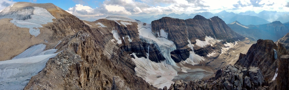
Panorama from the buttress with the summit of Mount Ball still above! Our bivy site is in the glacier carved valley far below on the right. Click to see larger.
.jpg)
The glacier across the valley perfectly framed by a steep gully on my way down the buttress. The descent from the buttress was, thankfully, snow-free and, therefore, straight-forward.
.jpg)
The summit push! At the col between the buttress and Mount Ball. At this point, I decided to leave my pack behind, bringing only my camera and my Spot GPS in the hopes of making better time carrying less weight. The snow field above was rock hard and icy so I stuck to the rubble and scree on the right of it gaining the ridge before hurriedly making my way to the summit.
.jpg)
Panorama from above the icy snowfield. An interesting interplay of cloud and smoke with the evening light casts some interesting shadows on the Vermillion Range. Click to see larger.
.jpg)
Finally! 10 hours after leaving the car, I step foot on the summit and am greeted with the stunning view of the glacier below the ascent ridge (buttress on the left, Beatrice Peak and a chilly Mike sheltering on the right). Dark skies hint of potential trouble but I didn’t think much of it since it had been similarly overcast all day and the forecast had called for a zero percent chance of storms (of course, the forecast had also called for sun).
.jpg)
At the edge of the massive rock bench, the glacier below drops thousands of feet straight down into the valley.
.jpg)
Looking beyond Mount Whymper and Chimney Peak towards Lake Louise giants (Mount Biddle, Mount Hungabee, Deltaform Mountain, Mount Lefroy, Quadra Mountain, Bident Mountain and massive Mount Temple).
.jpg)
Storm Mountain and the Bow Valley beyond to the north.
.jpg)
The Castle Mountain massif looks small from over 500 m higher up.
.jpg)
Looking south over yet another glacier. Sunshine Meadows to the left and Egypt Lakes to the right.
.jpg)
The glacier plunges over the east escarpment with Haiduk Lake, Pharaoh Peaks, Haiduk Peak and Scarab Peak to the south.
.jpg)
Looking 4,000 feet down to Shadow Lake.
.jpg)
A stunning summit panorama. Worth every bit of suffering? Tough to say because the suffering wasn’t over yet…Click to see larger.
.jpg)
A sharp rocky outlier juts out of the glacier. Isabelle Peak and the Bugaboo Spires beyond.
.jpg)
Although I would have loved to stay on the summit taking photos for hours, I didn’t have hours of daylight left (it was 6:00pm by this point) and I had a friend waiting on the connecting ridge to Beatrice. It was time to make haste and get going again. A note: in his trip report, Soistheman mentions that there is no register on Ball. For this reason, I had brought a new one up with the intention of placing it, however, the new register was left in my pack at the buttress when I decided to shed some weight for the summit push. As a result, there’s still no register on Mount Ball. Someone please bring one up. There should definitely be a record of everyone who suffers enough to get up here!
.jpg)
As I began my speedy descent, I started to notice that the clouds to the west looked more ominous than before. My pace quickened. After descending to the buttress, I still had to climb back up it and then make my way along the ridge towards Beatrice Peak for a good distance before it would be safe to descend. The last thing that I wanted was to get caught in a storm up high and low on energy after a physically taxing day. I watched in horror as the clouds moved closer overtaking Vermillion Peak and Mount Haffner. My blood pressure shot up as the thunder rumbled nearby. A bright flash and a near instantaneous earth-shaking boom. Run. I needed to get to my ascent gully as quickly as possible to lose elevation. A summit ridge is no place to be in a lightning storm but there were no safe options for descent until I got back to the ascent slopes near Beatrice Peak. I hoped that Mike had built his “I’m getting the F down” cairn and was safe in the valley below worrying about me.
.jpg)
The GTFD cairn! I zoomed in with my camera to confirm its existence and as soon as I saw it I started to lose elevation, side-hilling my way back to our ascent gully. My original intent had been to meet up with Mike and complete the easy 5 – 10 minute hike to the summit of Beatrice Peak together. From Beatrice, the descent is easier and faster. Unfortunately, I didn’t have the leisure of gaining elevation at this point and, as a result, Beatrice and my easy descent were off the table. I would have to run down the closer knee-jarring ascent gully. Making your way down a big peak in a lightning storm is a fine balance. You need to lose elevation as quickly as possible but, at the same time, you need to descend carefully. Dodging the lightning does little good if you fall because of your haste.
.jpg)
The worst of the storm hits as I clear the waterworn gully about half-way down. I had to be extra careful since the rock was quite slippery once wet. In this amphitheatre, the thunder echoed off of everything. I was awed by the storm’s power.
.jpg)
Thank God. The clouds begin to lift. Having not had a break in a LONG time, I allowed myself the luxury of taking five once the storm passed, eating a slice of leftover pizza and replaying the last hour in my mind before continuing towards our bivy hoping that Mike was safely there waiting.
.jpg)
Back at the bivy safe and sound, I was happy to find Mike likewise. We swapped notes as we shared the couple of beers that we had hiked in. Mike had noted the storm coming as he watched my progress along the ridge. Wanting to be able to take advantage of the easier descent from Beatrice, he decided to build the GTFD cairn and headed up Beatrice, briefly enjoying the summit before scree skiing down. He was able to shelter half way down the mountain and avoided the worst of the storm beating me back to the bivy by about 20 minutes.
.jpg)
Evening alpenglow on our bivy from our dinner-cooking area. Mount Ball behind in the center. Unfortunately, the storm hit so late in the day that our clothes had no time to dry. We put on anything that we had left which was dry and got ready to settle in for a cold night.
.jpg)
Bivy site panorama. What a wonderful place to spend the night! Pity there’s not a better way to get up here! Click to see larger.
.jpg)
A hard-earned ale.
.jpg)
Watching the sun set over massive peaks to the west.
.jpg)
As we watched the sun set, a large plume of smoke from the nearby wildfire rose swiftly up Haffner Creek Valley overtaking us and obscuring everything. Luckily the smoke dispersed as quickly as it came in and we had fresh air to breathe 10 minutes later.
.jpg)
The next morning we awoke to the local whistling alarm.
.jpg)
All packed up and heading out. We had thought about making our way up Stanley Peak while we were in the area but the previous day had taken its toll and, knowing that we still had a difficult 5 hour bushwhack with heavy packs ahead of us, we opted to pack out instead.
.jpg)
“What kind of God would allow a valley like this to exist?” I distinctly remember thinking that somewhat sarcastically as navigated the minefield of logs on our way out. As it would turn out, it was VERY fortunate that we decided to pack out without attempting Stanley. Although I didn’t realize it at the start of the day, the frantic descent of Ball the day previous had taken a massive toll on my right knee. The tendons behind it stiffened badly as we descended the steep headwall and it began to hurt a little more with every log we hopped. For the last hour of our descent, I could barely lift my right leg. Mike gave me an extra pole and using 2 poles as crutches, I dragged my leg behind me, pausing every few steps in an attempt to manage the pain. The bushwhack became excruciating. There was no end to the awful brush and my pain amplified my growing frustration. When we finally managed to reach the campground, I collapsed on the side of the road while Mike made his way to the car, driving back to retrieve me.
.jpg)
The end to our adventure on Mount Ball. In the end, Mount Ball was the most physically and emotionally taxing mountain that I have ever climbed. Was it worth it? Absolutely.
.jpg)
.jpg)
.jpg)
.jpg)
.jpg)