With my wedding to my beautiful fiancé Brianne fast-approaching on Saturday September 14, my boss was good enough to tell me to take Thursday and Friday off in order to get everything organized and to keep my wife-to-be from getting too stressed out before the big day. With so much to do in the hours leading up to a wedding this was a real blessing! So what did I do? Decide to climb a mountain, of course (after all, it seemed unlikely that I would get to bag a peak on the weekend)! You may only get married once but a perfect mid-September weather forecast over the Rockies is almost as rare and I just had to take advantage of it. Since it was a Thursday in September, I reasoned that the stand-by line for the Lake O’Hara bus might be manageable (does anyone EVER get through to the reservation line?) and I couldn’t think of a better place to visit on a perfect blue-bird day. The only catch? I had to be back in town at a reasonable hour to pick up my tuxedo and wedding cake lest Brianne kill me before we even got a chance to say our “I do”s.
.jpg)
Despite leaving Calgary at 5:15am, I was still unable to get onto the Lake O’Hara bus stand-by (I was there early enough to get onto the waiting list only to be told, after waiting 30 minutes, that there wouldn’t be room for me). So while all the “suckers” on the bus enjoyed the views of the inside of a cheese-wagon on their quick ride up the 12 km fire road, I was allowed the time to treat myself to brilliant early morning views (like this one of Mount Victoria) the whole walk up.
.jpg)
OK, perhaps I’ve oversold the views from the fire road slightly. After a couple consecutive kilometers in the cold, shaded forest, I was starting to find trickles through the trees photo-worthy. Bet those warm and still energetic folks on the bus are sorry they missed this…
.jpg)
Fortunately, I wasn’t stuck in the cold dark forest for too long and after booking it up the road for 110 minutes, I found myself bathed in warmth and light as the sun rose above the massive peaks of the continental divide at Lake O’Hara.
.jpg)
Taking a moment to enjoy scenic Lake O’Hara after a brisk ascent.
.jpg)
The day’s objective, Mount Schaffer, to the south-west of Lake O’Hara. When starting from Lake O’Hara, Schaffer is a relatively small scrambling objective (580 vertical meters), however, tacking the fire road onto the approach makes it an honest day’s work, almost doubling that total and adding some long and dull kilometers to the horizontal distance.
.jpg)
One last shot of the morning sun rising as Glacier Peak (left), Mount Yukness (center) and Mount Hungabee (right) tower above the lake. Although, it would be easy to get tricked into taking photos all morning by the lake, there was still business (a summit) to attend to! From O’Hara, I quickly located the signed trail to Schaffer and McArthur Lakes near “Le Relais” and the bus stop. The trail moved swiftly past the ACC hut and up through pretty forest and is in fantastic condition. All branches are well-marked and it would be very difficult to get lost up here (Kananaskis, please take note)!
.jpg)
In a short time (20 minutes or so), I reached Schaffer Lake (where the scramble up Schaffer begins) and was greeted with an awe-inspiring view of tiny Wiwaxy Peaks (left) and massive Mount Huber (right) reflected in lake (ahem – tarn)’s still waters. Click to see larger.
.jpg)
When you arrive at Schaffer Lake, the grassy ascent slope can be seen on the far side of the lake. You can easily reach this slope by following a good trail around the lake in a counter-clockwise direction. Once around the lake, ascend grassy slopes aiming for one of the two cols above (it doesn’t really matter which). The summit is to the climber’s left of the cols. There are also several popular climbing routes up Schaffer but I prefer groveling up scree!
.jpg)
The “do not walk here” sign left by Parks Canada conveniently marks the start of a faint trail up Schaffer from the far-side of the Lake. At least tread lightly if you’re going to defy it! ;)
.jpg)
Making my way up the grassy slope and back into the sunshine.
.jpg)
Just below the cols, the summit comes into view on the left. From here, I easily made my way across talus and sand to the col on the right. The summit remains above on the left.
.jpg)
Looking back down the valley from the col as Schaffer Lake finally escapes the shadow of its namesake mountain. Click to see larger.
.jpg)
Once at the col, massive McArthur Lake is beautifully revealed to the other side of Mount Schaffer.
.jpg)
Mount Biddle beyond McArthur Lake.
.jpg)
From the col, the ridge to the summit looks entertaining. On ascent, I followed a multitude of cairns which guided me along the ridge crest. The scrambling on the ridge crest was fun but more challenging than I was led to believe from other trip reports – it was certainly moderate not easy. On descent, however, I did manage to find an easy way down. If you’re looking to stay on the easy route, follow the ridge for a couple minutes from the col until you reach a good ledge leading to a gully on the climber’s left. Use the ledge to gain the gully and ascend easily to the summit.
.jpg)
Typical terrain on the ridge. The large cairn above on the left is what suckered me onto the ridge crest where terrain was more moderate in nature. The ridge was fun, however, and I highly recommend it for confident scramblers. For less experienced scramblers, see below:
.jpg)
This photo was taken at the same spot as the one above. The cairn in the immediate foreground is the fork that divides the easy route (left) from the moderate route (right) along the ridge crest. The easy gully is obvious ahead and a good wide ledge (where the shadow meets the sun) provides a straightforward way across to it. On descent, I built a cairn at the end of this ledge since all of the cairns on ascent guided me onto the ridge. As you can see, the terrain on the right which I ascended becomes much steeper. Regardless of which way you choose to go, you’re soon in for a treat!
.jpg)
On top, the bright register adds a splash of color to a beautiful landscape including (from left to right): Little Odaray, Mount Odaray, Mount Stephen and Cathedral Mountain.
.jpg)
Little Odaray (also an easy/moderate scramble) and Mount Odaray.
.jpg)
Cathedral Mountain.
.jpg)
Easy for me to say but Mount Stephen doesn’t look THAT bad from this side. Of course that’s because you can’t see the 2 km vertical drop to Field on the other side. If you look closely, you can see the structure at the summit.
.jpg)
Looking back down the long approach valley towards (from left to right): Mount Niles, the Waputik Icefield, Mount Daly, Paget Peak, Mount Bosworth and Wiwaxy (west) Peak.
.jpg)
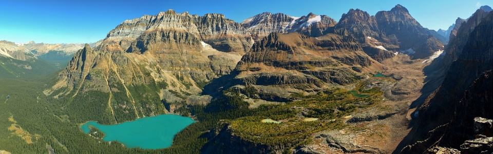
The real show-stopping panorama towards Lake O’Hara from the summit of Mount Schaffer. From left to right: Wiwaxy Peaks (west and east), Mount Victoria (north summit), Lake O’Hara, Mount Huber, Mount Victoria, Mount Lefroy, Glacier Peak, Mount Yukness (foreground), Ringrose Peak and Mount Hungabee. Click to see larger.
.jpg)
An even wider panorama including Mount Odaray, Mount Stephen and Cathedral Mountain (all to the left). Click to see larger.
.jpg)
“Getting ready” for my wedding!
.jpg)
The steep west walls of Mount Victoria.
.jpg)
Mount Lefroy’s steep ascent route.
.jpg)
Aptly titled Glacier Peak.
.jpg)
Glacier Peak and Ringrose Peak soar above Mount Yukness and the Opabin Plateau spotted with golden larches.
.jpg)
Ringrose Peak and Mount Hungabee.
.jpg)
The steep glacier-carved upper slopes of Mount Hungabee.
.jpg)
A network of wonderful hiking trails skirt about the lakes of the Opabin Plateau (from left to right: Moor, Hungabee and Opabin).
.jpg)
Glaciated Opabin Pass at the foot of Mount Biddle. The Valley of the Ten Peaks lies beyond.
.jpg)
Looking along the long connecting ridge from Mount Schaffer to much higher Mount Biddle. Exploring along the ridge proved to be fun moderate scrambling for a bit but I didn’t have time to get too far.
.jpg)
The panorama to the west featuring (from left to right): Mount Biddle, McArthur Lake, Park Mountain and Mount Owen. Click to see larger.
.jpg)
McArthur Lake shimmers in the hot afternoon sun.
.jpg)
The Rockwall to the south in the distance beyond the Biddle – Park col.
.jpg)
Another panorama to the west showing Park Mountain above McArthur Lake, Mount Owen, Mount Odaray and Mount Stephen. Click to see larger.
.jpg)
Beautiful green slopes and red rock on glacier-topped Mount Owen.
.jpg)
A distant Mount Vaux beyond the left shoulder of Owen.
.jpg)
The distant Selkirks beyond the right shoulder of Mount Owen.
.jpg)
Looking down steep gullies towards Park Mountain and McArthur Lake.
.jpg)
A long way down to Lake O’Hara and Mary Lake. Mounts Huber and Victoria above. Click to see larger.
.jpg)
Lake O’Hara and Mary Lake below the golden larches of the Opabin Plateau.
.jpg)
This cool overhang provided a convenient spot for a self-photo on top!
.jpg)
Still exploring along the ridge to the south – an interesting pinnacle provided a good place for me to turn around.
.jpg)
Interesting scrambling along the ridge leading back to the (lower?) summit of Mount Schaffer.
.jpg)
I can’t resist! One more panorama! Click to see larger.
.jpg)
Back at the summit at 1:30pm – it was my intent to catch the 2:30pm bus back from Lake O’Hara so that I could be back in Calgary in time to pick up my tuxedo. As a result, my descent was rather rapid!
.jpg)
Can’t leave without adding a typo to the summit register though!
.jpg)
Rather than descent the less scenic slopes to Schaffer Lake, I opted to descend to McArthur Lake from the col using the light-colored drainage in the center of this photo. Unfortunately, the drainage was comprised of rock hard dry dirt – where’s the loose scree when you need it?! Regardless, after a few knee-bashing moments, I found myself down amongst the pristine alpine meadows surrounding McArthur Lake.
.jpg)
Mount Biddle across McArthur Lake. I would have loved to stay at the lake and while away the afternoon but time was growing short!
.jpg)
I wandered across the alpine meadows by McArthur Lake until I a good trail which returned me to Schaffer Lake in short order.
.jpg)
Coming down through larch forest to Schaffer Lake. By this point I was running.
.jpg)
Mount Schaffer as seen from Schaffer Lake.
.jpg)
After a quick jog down, I arrived back at Lake O’Hara with 10 minutes to spare giving me time to dunk my head into the lake to cool off!
.jpg)
One last look at the Lake O’Hara panorama before heading down and rushing back into Calgary to pick up a tuxedo! From left to right: Mount Huber, Mount Victoria, Mount Lefroy, Glacier Peak, Mount Yukness, Mount Hungabee, the Opabin Plateau and Mount Biddle. Click to see larger.
.jpg)
My salvation from the fire road – the 2:30pm bus!
.jpg)
.jpg)
.jpg)
.jpg)
.jpg)
.jpg)
.jpg)
.jpg)
.jpg)