Ruby Ridge
Elevation: 2430 m
Elevation Gain: 888 m
Ruby Ridge extends to the southeast of the highest peak in Waterton National Park (Mount Blakiston) and was named for the vibrant red color of the rocks from which it is formed.
My Ascents:
May 25 2013
Trailhead: Lineham Creek Trailhead
After a week of rain in Calgary, the mountains on the horizon were starting to look quite white (when you could see them through the cloud and moisture that is). This, compounded with a nasty forecast (more rain) for Saturday, prompted me to extend my usual range in an attempt to find better conditions for bagging a peak. Imagine my surprise when I noticed that the Saturday forecast for Waterton was reasonably pleasant (mainly sunny) unlike any other region in the Canadian Rockies. Better still, a quick check of the waterton webcam revealed surprisingly dry conditions! And so it came to pass, that Gord and I made the 3 hour drive south (despite the fact that we were due back in Calgary for a family dinner that evening) to seek out the sun (and hopefully a summit)!
.jpg)
Early views of Ruby Ridge’s south-facing grassy flank from the Lineham Creek approach trail. We walked along the trail for about 2 km, gaining a cool 200 m of elevation easily, before we eventually decided to point our noses up the hill and start the grind in earnest.
.jpg)
The grind: steep grass slopes dotted with stunning wildflowers (surprisingly early for them to be out!). The slope is sufficiently steep to get the heart rate up but, fortunately, the spectacular views of Mount Lineham’s north face give you an excuse to pause and enjoy the view frequently!
.jpg)
Some of the aforementioned wildflowers: crocuses on steroids.
.jpg)
Equally pretty: brown-eyed susans.
.jpg)
Above the steep grass slopes, a ruby red scree grind ensues. Here Crux tries to get his paws on some solid footing!
.jpg)
Stunning views of Lineham Creek pouring down from the high plateau between Mounts Lineham (left) and Hawkins (center).
.jpg)
At this particular point, Lineham Creek is more of a cascade…
.jpg)
Taking a break to admire the view.
.jpg)
The aforementioned view! Cameron Lake appears in the distance (left) as we gain elevation. The Hawkins Horseshoe (Mounts Lineham, Hawkins and Blakiston from left to right) provide motivation to maintain our perspiration. Click to see larger.
.jpg)
Sizing up the ascent route on Mount Blakistion, the highest peak in Waterton National Park.
.jpg)
Shockingly, we didn’t encounter any snow until the final 50 or so vertical meters of the route.
.jpg)
On top! As you can see by Crux’s ears (they’re normally flopped over), the notorious Waterton wind was up to its usual tricks…
.jpg)
Gord makes his way up the final summit slopes of Ruby Ridge with (you guessed it) “more impressive peaks to the south.”
.jpg)
Ruby Ridge summit panorama: looking down the length of red Ruby Ridge towards the slightly lower (but much redder) eastern peak. In the distance (from left to right): Cloudy Peak, Mount Dungarvon, Mount Galwey and Bellevue Hill give way to the prairies. Click to see larger.
.jpg)
Ruby Ridge and Mount Crandell above the Akamina Parkway (bottom right).
.jpg)
A closer view of Mount Crandell. It looks tame from this angle but the scramble routes that ascend the other side have some teeth!
.jpg)
If you look closely, you can make out 1 lonely wind turbine in the flat lands beyond Ruby Ridge. Based on the wind that we ran into on the summit, they might want to consider building a few up top!
.jpg)
Gord warming his hands up on Crux.
.jpg)
For a lower peak in the very front ranges, Ruby Ridge offers and absolutely spectacular summit panorama! I can see why Andrew Nugara keeps coming back! Click to see larger.
.jpg)
Frozen Ruby Lake tucked in at the base of massive Mount Blakiston.
.jpg)
Mount Dungarvon and Blakiston to the north. The red rocks of Red Rock Canyon are tucked in along the base of this range.
.jpg)
Looking west along Ruby Ridge towards Mounts Lineham and Hawkins.
.jpg)
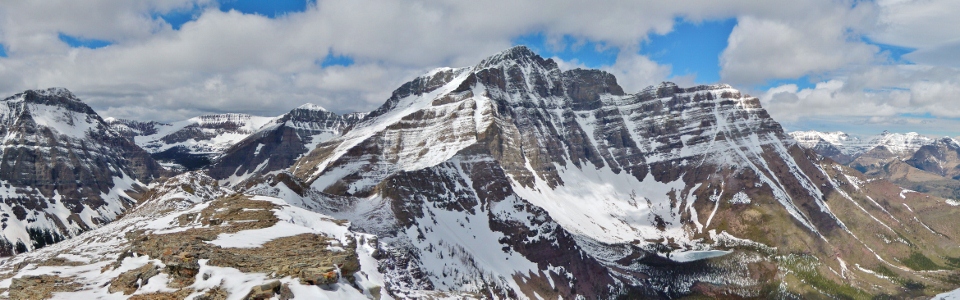
The panorama of “more impressive” (and cloudier) peaks to the south. Click to see larger.
.jpg)
Cameron Lake at the base of Mount Custer’s steep north face. Scenic Akamina Ridge extends to the right beyond Forum Peak.
.jpg)
A semi-solid Cameron Lake. A little early for canoe rentals yet.
.jpg)
The corniced top of Akamina Ridge to the south.
.jpg)
My turn to warm up my hands!
.jpg)
Gord and I enjoying our first summit together for the season! buchanan Peak and its many outliers beyond.
.jpg)
Prominent Kaiser Point juts out along the north ridge of Mount Cleveland, the highest peak in Montana’s Glacier National Park.
.jpg)
Mount Cleveland makes a rare (on this day) appearance to the right of Kaiser Point.
.jpg)
Prominent Chief Mountain to the east. The peak is the southern extreme of the Lewis overthrust which extends north all of the way to Mount Kidd in Kananaskis Country.
.jpg)
Sharing my lunch.
.jpg)
One last picture with Mount Blakiston before heading back down to warmer, less windy ground!
.jpg)
Crux enjoying one of Gord’s many photo breaks on the way down.
.jpg)
Gord consistently looked for the most challenging way down, avoiding pleasant soft scree in favor of rock bands at every chance!
.jpg)
A carpet of glacial lilies below the scree.
.jpg)
Back on the Lineham Creek trail amidst lilies and Buchanan Peak.
.jpg)
The mad photographer sitting in a creek to capture that “perfect picture”.
.jpg)
Park Patrol back on the highway…maybe they’re looking for red rocks that some might consider taking for their gardens back home? Purely hypothetical...
.jpg)
.jpg)
.jpg)
.jpg)