With my 30th birthday fast approaching (time flies when you’re bagging peaks), Brianne and I tried to decide upon an appropriate peak to ascend in order to mark the occasion. To my surprise, Brianne (who prefers hands-on type scrambles) suggested Sunwapta Peak. Although Kane’s description makes Sunwapta sound like a MASSIVE SLOG, it had been on my radar for years now and I decided to go along with her suggestion since taking on an elevation gain greater than that required to climb Mount Temple is the sort of thing that sounds like fun to me. As my birthday (and August long weekend) approached, the forecast for the mountains looked gloomy but, having already reserved beds at the nearby Beauty Creek hostel, we were committed to a trip to the Columbia Icefields. After mingling with the throngs of tourists on the Brewster’s “Glacier Adventure” and testing our rain jackets in a downpour at the hostel the day prior, we held our breath and hoped for decent slogging weather on my birthday.
.jpg)
After a night full of rain and awaking to thick fog, we were not optimistic, however, shortly after breakfast the clouds began to break revealing blue skies over the Columbia Icefields. The ascent of Sunwapta was on!
.jpg)
Tangle Ridge looks much more impressive from the north than it does from the southern slopes that are used for its ascent. Our plan for the weekend was to enjoy my birthday (August 3) on Sunwapta and to join my parents for my dad’s 65th birthday (August 4) on Tangle the next day.
.jpg)
The highway-side view of Sunwapta Peak from the starting point (the unsigned Stanley Falls trailhead) does not do this behemoth justice. Here you can see the summit of Sunwapta, at an elevation of nearly 11,000 feet, ensconced firmly in the clouds.
.jpg)
Following Kane’s directions, we easily found the excellent ascent trail through the woods on the north side of a major drainage. The sun rising straight ahead of us to the east leant an ethereal quality to the hike through the rain-soaked spruce.
.jpg)
In places the drainage steepens sending the small creek cascading over waterfalls and down scenic canyons.
.jpg)
Our first, badly foreshortened, glimpse of the upper section of the mountain from above the canyon. The hike to the tree line involves an elevation gain of 700 vertical meters. From there, you still need to ascend over 1000 vertical meters of feature-less scree.
.jpg)
The view back from the tree line is already spectacular! With the summit still 1000 meters above us, we can only hope that the forecast storms don’t come to pass. Click to see larger.
.jpg)
The impressive north face of Tangle Ridge towers above a sharply carved cirque.
.jpg)
The glacier which abuts the north side of Tangle Ridge – clearly, it’s best to stay on rock and off of snow on the summit of Tangle! You can make out the summit repeater station on top.
.jpg)
Brianne “enjoying” the view. Actually, this was the site of a small and cute (in retrospect) tantrum. She was already tired at this point and the swarming bugs and endless scree exacerbated matters. We actually ended up having a small fight here. While the fight made the next little bit more unpleasant, it did seem to motivate her; apparently she climbs quickly when she’s angry!
.jpg)
While Brianne did not enjoy the view at this point I did; particularly the beautiful view of Diadem Peak (left) and Mount GEC (right) above a small icefield.
.jpg)
Unpleasant looking weather over Mount Athabasca to the south. Given the awful forecast, I was keeping a keen eye on the weather in all directions. Fortunately, the weather held until that evening when the first couple of rain drops began to fall as we reached our car on descent.
.jpg)
Brianne grovels up the endless scree into the clouds.
.jpg)
Looking south along Beauty Creek towards giants like Mount Saskatchewan, Mount Athabasca and Mount Andromeda.
.jpg)
The striking glacier on the north face of Nigel Peak. Beyond Nigel Peak, the distant glaciated summit of Mount Amery can be seen on the right.
.jpg)
Poor Brianne continuing to grind her way up as the peaks of the Columbia Icefield (left) and the Winston Churchill Range (right) come into view above the Sunwapta River.
.jpg)
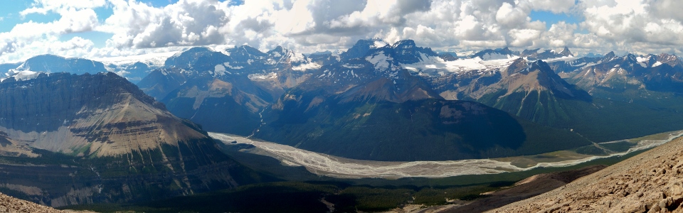
Sunwapta Valley panorama from “still not at the top”. Click to see larger.
.jpg)
Great views of Mount GEC, Mount Nelson, pointy Mount Smythe and Gong Peak (from left to right).
.jpg)
Mount Smythe is a real eye-catcher.
.jpg)
The clouds part over the Winston Churchill Range and Mount Alberta makes a brief appearance beyond Mount Wooley.
.jpg)
FINALLY on the ridge crest – but still not on the summit. A sea of peaks unfolds beyond the steep south-east face of Sunwapta. Click to see larger.
.jpg)
Continuing up the ridge crest. Could that finally be the summit? Don’t worry, it wasn’t!
.jpg)
Slog, slog, slog. Mount Columbia comes into view in the distance.
.jpg)
Mount Columbia beyond the Kitchener (left) and Stutfield (right) Glaciers.
.jpg)
The heart of the Columbia Icefields, Mount Columbia is the second highest peak in the Canadian Rockies.
.jpg)
The massive North Twin (third highest peak in the Canadian Rockies) and the Twins Tower beyond Mount Stutfield.
.jpg)
FINALLY on the summit! After 1735 vertical meters (over only 6.5 km) she even managed a smile on top!
.jpg)
Register entry documenting the ascent, the birthday and the fight!
.jpg)
Finally a panorama from the summit! From left to right: Mount Kitchener, Tangle Ridge (foreground), Mount Columbia (distant), Mount Stutfield, North Twin (distant), Twins Tower (distant), Mount Cromwell, Mount Engelhard, Mount Wooley, Mount Alberta (in the clouds), Mushroom Peak (foreground), Diadem Peak, Mount Clemenceau (distant), Mount GEC, Mount Nelson, Mount Smythe, Gong Peak, Mount MacGuire and Catacombs Mountain (distant). Click to see larger.
.jpg)
A distant Mount Clemenceau (fourth highest peak in the Canadian Rockies) is visible between Diadem Peak and Mount GEC.
.jpg)
Distant icefields beyond Mount Smythe.
.jpg)
Catacombs Mountain beyond Gong Peak (left) and Mount MacGuire (center).
.jpg)
The (now) happy summit couple.
.jpg)
The feeble looking summit cornice and a sea of dip-slope peaks to the south.
.jpg)
The Brazeau Icefield (left) and Poboktan Mountain illuminated in the afternoon sun to the east.
.jpg)
Looking north along the Icefields Parkway to Jasper.
.jpg)
Mount Brazeau and its icefield to the north-east.
.jpg)
The braided Sunwapta River and a series of tiny vehicles 1735 meters below.
.jpg)
Happy birthday shot before heading down.
.jpg)
The descent was almost as much fun as the ascent…
.jpg)
Back at the tree line and still a lot of ground to cover. At this point, Brianne and I both had visions of beer and potato chips dancing in our heads!
.jpg)
When we reached the bottom of the drainage on descent, we opted to “bushwhack” straight to the highway, rather than following the old road south until it met the Stanley Falls trail. This proved to be a brilliant decision as it cut off the final 10 minutes of the descent and deposited us right at our car. The bushwhacking was so minor that this small creek crossing was the largest obstacle we encountered! Once back at the car, it was an unusually short (2 km) drive to get back to our beds at the Beauty Creek hostel where my parents had checked in and birthday dinner was waiting for us after a long day! Up next: Gord’s birthday and an attempt at Tangle Ridge!
.jpg)
Sunset on the Sunwapta River as seen during a brief respite from the evening rain at the hostel.
.jpg)
.jpg)
.jpg)
.jpg)