With the summer officially in full swing, Brianne and I decided that our first camping trip of 2014 was overdue. Our weekend itinerary would call for campfires, fresh air, peak bagging and a wild ride down the Kicking Horse River! While we love the back-country, we only had 3 days off (and aren’t huge fans of heavy packs) so we opted to stay at the walk-in Takakkaw Falls campground in Yoho National Park. The walk-in sites there offer a fairly authentic back-country experience a short 5 minute walk from the parking area (plus it’s fun to throw your gear into the “wheel barrows” provided).
After a cool evening spent trying to start a fire with wet wood and no axe (thank God for newspaper…LOTS and LOTS of newspaper), we made our way to Emerald Lake. This marked Brianne’s first visit to beautiful Emerald Lake and while she enjoyed the view from the shore, she thought that the best place to see the lake would probably be from the top of Emerald Peak (okay, that bit may have been my suggestion). Regardless of whose idea it was, we were soon making our way up the steep switchbacks of the Hamilton Lake trail with the goal of scrambling up the south ridge of Emerald Peak.
.jpg)
“It’s pretty, I guess, but can’t we climb that peak to get a better view?” ;-)
.jpg)
Reflections of Emerald Peak (left) and the President (right) dance in the turquoise waters of Emerald Lake. Click to see larger.
.jpg)
A loon paddles through the glacial waters – it doesn’t get any more Canadian than this.
.jpg)
We were sure to enjoy the trailhead views of Emerald Lake, tanking up on scenery like a camel tanks up on water, before undertaking the somewhat dull 5.3 km hike through the forest to Hamilton Lake. What the trail lacks in terms of scenery, however, it makes up for in efficiency, accounting for a significant portion (850 m) of the day’s elevation gain.
.jpg)
Hamilton Falls offers a scenic respite from the dense forest.
.jpg)
After enduring the hike, we were rewarded with spectacular alpine views of Mount Carnarvon (left), Top Hat Peak (center) and Emerald Peak (right) upon reaching Hamilton Lake. Click to see larger.
.jpg)
From Hamilton Lake, we followed animal trails up a small grassy hill on the lake’s southeast shore aiming to intersect the south ridge of Emerald Peak. Thanks to fresh goat prints, we were able to follow the faint trail all the way to the south ridge with relative ease. As you can see, the goats in this area (including the one in the picture) prefer to take a rather steep line up!
.jpg)
Brianne pauses on her way up the south ridge to admire the spectacular view of Emerald Lake.
.jpg)
Making her way up gently graded Yoho shale towards the false summit ahead. We stuck to the ridge crest here, necessitating a moderate down climb from the false summit; however, both the false summit and the down climb can be avoided on a broad scree ledge to the climber’s left.
.jpg)
Beyond the false summit, the final bit of ridge towards the true summit becomes more interesting, featuring pinnacles, cracks and chasms (all of which can be by-passed by moderate means). All the while, Mount Carnarvon provides a scenic backdrop. Click to see larger.
.jpg)
After by-passing the large pinnacle to the climber’s left, we entered a large corridor formed by steep rock walls. Eventually, the corridor funnels into a tunnel formed by a myriad of chockstones.
.jpg)
After squeezing through the tunnel, Brianne emerges to find a broken landscape near the summit.
.jpg)
A chasm separating the tunnel from the summit. The easiest way across? Jump! Once across this final obstacle, the summit was only a minute or so away.
.jpg)
Catching her breath and enjoying the view from the summit after an interesting finish to the scramble.
.jpg)
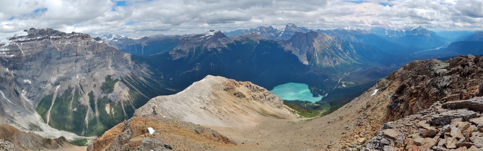
The panorama to the north of the summit features a number of peaks including (from left to right): Mount Carnarvon, Top Hot Peak, Mount Marpole, the President and the Vice President. Click to see larger.
.jpg)
Mount Carnarvon.
.jpg)
The Vice President.
.jpg)
A closer look at the Emerald Glacier atop the Vice President.
.jpg)
A very presidential summit photo!
.jpg)
The pastel waters of Emerald Lake highlight the panorama to the southeast. Click to see larger.
.jpg)
Emerald Lake and the Emerald Lake Lodge at the foot of Emerald Peak. During winter months, the avalanche gully in the foreground makes for a popular 1200 vertical meter back-country ski run.
.jpg)
Looking east towards the Wapta Icefields, Mount Daly (center left), Mount Niles (center right) and Mount Ogden are readily discerned.
.jpg)
A closer look at the challenging summit block of Wapta Mountain.
.jpg)
Massive peaks visible beyond Mount Burgess (foreground) include (from left to right): Mount Victoria (background), Cathedral Crags, Cathedral Mountain, Glacier Peak (background), Ringrose Peak (background), Mount Stephen, Mount Biddle (background), Mount Odaray (background) and Park Mountain (background).
.jpg)
A closer look at the spectacular north face of Mount Stephen.
.jpg)
The standard On-Top summit pose.
.jpg)
The colorful panorama beyond the summit ridge pinnacles towards Mount Carnarvon (right), Hamilton Lake and the peaks of the Van Horne Range (left). Click to see larger.
.jpg)
Hamilton Lake.
.jpg)
After a short stay on the summit, it was time to retrace our steps (and leaps) back down the south ridge. While it is also possible to descend the avalanche gully directly to Emerald Lake, we reasoned that travel along the good trail from Hamilton Lake would be less bushy and, likely, more enjoyable.
.jpg)
Brianne squirms her way back down the tunnel.
.jpg)
Making our way back through the corridor formed by steep rock walls.
.jpg)
With all of the moderate terrain behind us, we took a moment to enjoy the view of Emerald Lake before plunge stepping down scree and making our way back to Hamilton Lake.
.jpg)
Just before re-entering the scenery-challenged forest, the clouds began to lift granting us improved views of the Ottertail Range to the south.
.jpg)
Ottertail giant Mount Vaux and the impressive Hanbury Glacier.
.jpg)
The second highest mountain in the southern Canadian Rockies: Ottertail giant Mount Goodsir (south tower to the left and north tower to the right).
.jpg)
After a speedy descent of the Hamilton Lake trail, we decided to investigate the beer selection on the Emerald Lake Lodge’s patio.
.jpg)
The beer always tastes better after bagging a peak!
.jpg)
Back at the Takakkaw Falls campground, we enjoyed a pleasant summer evening around the campfire (with a couple more beers as you can see from the picnic table).
.jpg)
Takakkaw is the Cree word for “magnificent” and, as you can see, the view of Takakkaw Falls from our camp site was!
.jpg)
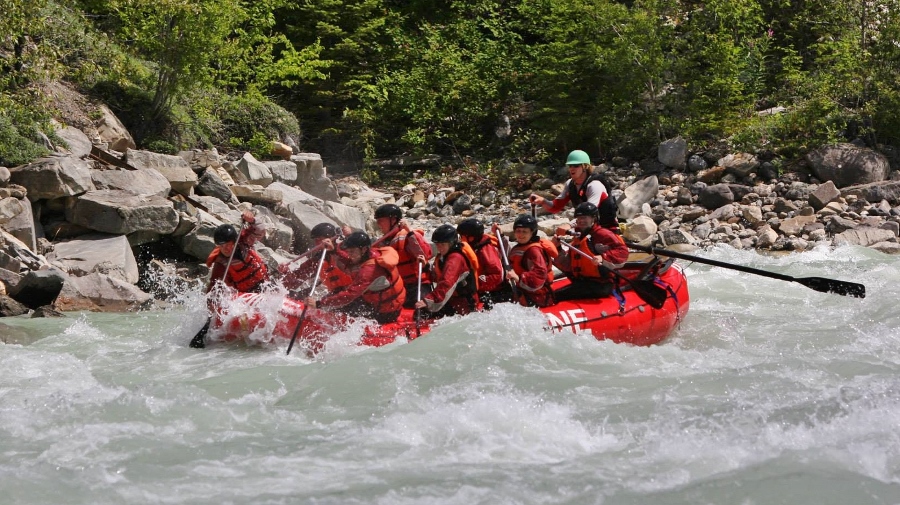
Watching the sun set on the Yoho Glacier provided a beautiful end to our day – but the adventure wasn’t over yet. Since Brianne got her way and we scrambled up Emerald Peak, it was my turn to pick an outing for the next day! “My” choice? An exciting day white water rafting on the Kicking Horse River! For those interested, we highly recommend Alpine Rafting in Golden, BC!
.jpg)
.jpg)
.jpg)
.jpg)
.jpg)