Junction Hill
Elevation: 2236 m
Elevation Gain: 720 m
Junction Hill was presumably named for the junction of Highway 40 and Highway 541 which can be found at its southern foot.
My Ascents:
March 15 2014
Trailhead: Highwood Pass East Winter Closure Gate (Roadside)
GPS Track: Junction Hill
Generally, people don’t choose to spend their leisure time with their former bosses. Then again, most bosses aren’t fellow peak baggers. In a previous life, Roland was the professor who supervised my PhD work. He and I have always shared a love for mountains, beer and chemistry (in that order for me). Although we kept in sporadic contact through social media, I hadn’t seen him for a couple of years. It was, therefore, a pleasant surprise to receive an e-mail from him asking if I had any mountain-related ambitions for the upcoming weekend. I, of course, ALWAYS have mountain-related ambitions for the upcoming weekend so we put our combined brain power together in an effort to come up with a suitable outing. With the avalanche danger rated “High” throughout the Rockies and an unfortunate series of avalanche-related deaths in the past week, we opted for a conservative target: Junction Hill.
After a slight wine consumption-related delay to our original departure time, we eventually made our way to the mountains, parking near the winter closure gate at the junction of Highways 40 and 541.
.jpg)
The southwest ridge of Junction Hill, pictured here, proved little more than steep hiking. From the winter closure gate, we followed Nugara’s instructions and walked 600 m west along the closed section of Highway 40, eventually starting up the open grassy slopes at this highway sign.
.jpg)
The hillside here may not look steep but it felt steep!
.jpg)
Even Crux needed a break on his way up the steep grassy hillside.
.jpg)
Holy Cross Mountain dominates the view to the east on ascent.
.jpg)
Improving views of Highway 541 stretching to the south underneath a Chinook arch as we gain elevation.
.jpg)
The peaks of the continental divide provide a scenic backdrop for the twisted limber pines on Junction Hill’s windswept slopes.
.jpg)
Baril Peak, Mount Cornwell, Courcelette Peak and Mount Armstrong beyond Coyote Hills (and the marker) atop the first bump.
.jpg)
Telephoto of Mount Armstrong.
.jpg)
Mist Mountain framed to the north.
.jpg)
The wind picks up and the true summit (right) comes into view in the distance beyond the first high point.
.jpg)
Elevation gain, followed by elevation loss, followed by elevation gain…
Although the summit is only 720 m above the highway, the actual elevation gain for the day is closer to 940 m by the time all of the ups and downs of the ridge are factored in.
.jpg)
The summit finally comes into view.
.jpg)
Roland makes his along the rocky ridge to the summit underneath the cool winter sun.
.jpg)
Larger peaks to the west are the highlight of the summit panorama. Click to see larger.
.jpg)
Crux enjoying his customary summit rest.
.jpg)
The dramatic rock folds of Mount Head to the northeast.
.jpg)
Holy Cross Mountain directly to the east.
.jpg)
The panorama to the east includes Holy Cross Mountain, diminutive Gunnery Mountain and a distant Mount Burke. Click to see larger.
.jpg)
Looking east beyond Gunnery Mountain to the prairies.
.jpg)
Telephoto of Mount Burke and its long abandoned summit fire lookout.
.jpg)
Mount Armstrong, Mount McLaren, Mount Strachen and Mount Muir make an adequate backdrop for our group summit picture.
.jpg)
Continental divide panorama. From left to right: Mount Etherington, Baril Peak, Mount Cornwell, Courcelette Peak and the flank of Mount Armstrong. Click to see larger.
.jpg)
The small bluff in the foreground provided our only shelter from the frigid west wind blowing off of Mounts Strachen, Muir, McPhail and Bishop (left to right).
.jpg)
A closer look at Mounts Muir and McPhail.
.jpg)
Telephoto of Mist Mountain to the north. Mount Tyrwhitt also visible to the left.
.jpg)
Summit selfy before running down to escape the freezing wind.
.jpg)
Roland making his way back to the first high point with Raspberry Ridge in the distance on the right.
.jpg)
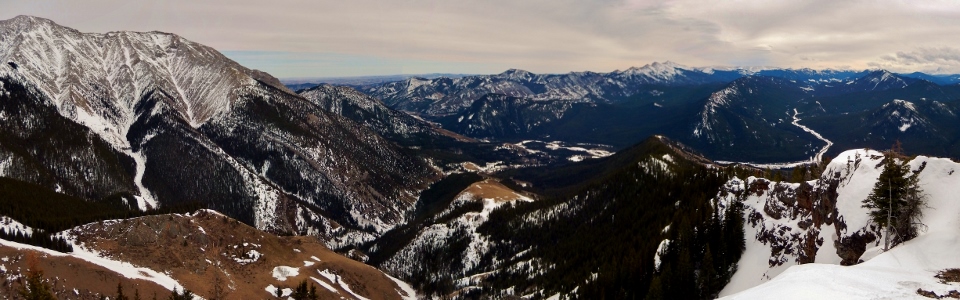
Enjoying the final panorama from the first high point (now that we’re out of the hurricane winds). Click to see larger.
.jpg)
Final views of Mount Armstrong from the lower slopes of Junction Hill. While Junction Hill was not the most entertaining objective:
• It kept us away from any questionable avalanche terrain during a dangerous season.
• It provided pleasant views of some of the more obscure continental divide peaks of the High Rock Range.
• And finally (and most importantly), it provided a short enough outing to allow us to refresh ourselves at the pub in Black Diamond on the way home!
.jpg)
.jpg)
.jpg)
.jpg)