Bull Creek Hills
Elevation: 2179 m
Elevation Gain: 750 m
Bull Creek Hills were officially named in 1980 for nearby Bull Creek which flows immediately to their north. Bull Creek was, ironically, renamed Cutthroat Creek in 1984 and, as a result, there is no longer a Bull Creek for the Bull Creek Hills to rise above. The hills rise up immediately to the east of Holy Cross Mountain and are a popular hiking destination year-round.
My Ascents:
January 25 2015
Trailhead: Highwood Day Use Area
GPS Track: Bull Creek Hills
Having just returned from a week of sun and sand in Mexico, I decided to make a trip out to the mountains for a winter hike in order to reacquaint myself with the snow and cold. With an eye towards freezing with good company, Crux and I arranged to meet with Raf (the Crazy Pol) and a couple of his friends, Sonny and Wietse, for a winter ascent of Bull Creek Hills in South Kananaskis. “Unfortunately”, the weather decided not to cooperate and instead of freezing, we were treated to sun and an unseasonably warm high of 11 degrees Celsius. Our disappointment was palpable, however, we opted to persevere and go through with the hike despite the “less than ideal” winter conditions.
.jpg)
Guidebooks suggest parking in the Highwood River Recreation Area parking lot, however, it was closed when we arrived so Raf opted to make the Kananaskis Country entrance sign is own personal parking lot. Several of the Bull Creek Hills (including the snowy summit of the right) are visible beyond the Chinook-tattered flags as the group gears up in the early morning light.
.jpg)
The ascent quickly yielded wonderful views of the larger peaks of the High Rock Range to the west thanks to the mostly open terrain.
.jpg)
Unwilling to follow guidebook instructions, we opted to ascend the west ridge of Bull Creek Hills (shown here) rather than the recommended route up the east ridge. We would end up descending via the east ridge making for a pleasant loop.
.jpg)
Sonny plows through the deepest snow that we encountered as the east ridge steepens.
.jpg)
Nearby Holy Cross Mountain makes its first appearance beyond the twisted remains of a Chinook-mangled pine.
.jpg)
Examining the route ahead: the treed west ridge (left) eventually leads to a false summit (center). The highest of the Bull Creek Hills is to the right of the false summit and the usual east ridge route extends downwards to the right from there.
.jpg)
Sonny works his way up the ridge as the prairies fall below us to the east.
.jpg)
Raf enjoys the sun-splashed slopes despite claims that he found them “mentally exhausting.” I suspect that Raf’s concocting of elaborate fairy tales involving “Dutchmen” and a “Big Bad Wolf” was the true reason behind his mental exhaustion.
.jpg)
Crux enjoys some "paws-on" scrambling as the west ridge becomes more interesting just below the false summit.
.jpg)
Raf poses seductively for any bikini girls who may have been around (it was warm enough out). Sadly for him, only Crux was interested.
.jpg)
After Raf finally realized that there were no girls around, we made our way to the false summit. Despite hoping for a view of bikini girls, Raf was forced to settle for the equally appealing view of Holy Cross Mountain (center) and Mount Head (right) with the snowy peaks of the High Rock Range beyond. Click to see larger.
.jpg)
The Highwood Range, including Patterson’s Peak (left) and pointy Pyriform Mountain (center right), rises above the foothills to the north.
.jpg)
While the day didn’t provide the freezing cold that I’d hoped for, I decided to put on a brave face nonetheless.
.jpg)
Baril Peak (center) and Mount Armstrong (right) dominate the view of the High Rock Range beyond diminutive Gunnery Mountain (center).
.jpg)
Crux makes himself comfortable on the false summit while Raf, Sonny and I wonder what happened to Wietse?
.jpg)
Presuming that we’d find Wietse on the slightly higher summit to the east, we set off to tackle the intimidating summit block shown here.
.jpg)
Thanks to Crux’s special skill for finding people eating their lunch on summits, Wietse was quickly located.
.jpg)
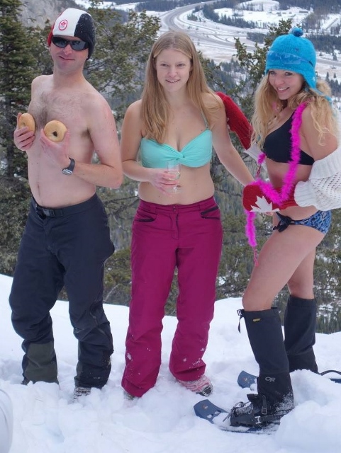
In a monochromatic mindset, Raf insisted on dressing everyone in orange for the group summit photo (photo courtesy Raf).
.jpg)
From the summit, the vast prairie stretches out to the east at the foot of Mount Burke (right) and the front ranges. Click to see larger.
.jpg)
Downtown Calgary stands out amongst the flat lands.
.jpg)
The Crazy Pol.
.jpg)
Wietse makes his first appearance On-Top (although he is no stranger to the Canadian Rockies).
.jpg)
Summit hacky sack? Crux looks like he wants to play…
.jpg)
MINE!!!
.jpg)
Posing for a summit photo as Crux claims his prize (sorry Raf – no more hacky sack).
.jpg)
Crux finds another snowy spot for a summit rest.
.jpg)
Sonny enjoys the last views from the summit (and makes sure that no one leaves their hiking pole behind) as we begin to make our way down the east ridge.
.jpg)
Wietse and Sonny make their way down the east ridge with the summit of Bull Creek Hills visible behind.
.jpg)
The fastest way down – provided your tailbone can handle the rocks just below the shallow snowpack.
.jpg)
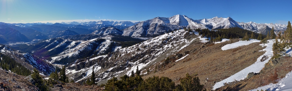
A final panorama from the east ridge (descent route on the left and summit on the right) on a spectacular January day – not an ideal way to reacquaint myself with the cold but I suppose that I’d best not complain; there’s still plenty of time left for that this winter (click to see larger)!
.jpg)
.jpg)
.jpg)