Labyrinth Mountain Attempt
Elevation: 2118 m
Elevation Gain: 600 m
Located near Ya Ha Tinda Ranch, Labyrinth Mountain was named by geologist D. M. Cruden for the maze of open passages contained between house-size blocks of rock upon it.
My Attempts:
March 22 2015
Trailhead: Cut Block (Roadside)
GPS Track: Labyrinth Mountain Approach
When the Crazy Pol (Raf) suggested an ascent of Labyrinth Mountain, a quick Google search revealed that beta for this tiny front range peak is almost all-together lacking (a situation which shall soon be remedied). Aside from the knowledge that a horse trail travels around the peak (fording the Red Deer River twice), we could find no information concerning the ascent. With a team of peak baggers and peak bagging puppies who apparently have nothing better to do, we set out on a foggy Sunday morning to see if we could find said trail and, hopefully, a pleasant route to the summit (spoiler alert: we invented the term “shit-erize” to describe sections of the ascent so you can probably venture a guess as to how pleasant it was)!
.jpg)
Powered by Raf’s Polish Synth pop, we drove past the Ghost Wilderness towards Ya Ha Tinda Ranch, stopping at an obvious cut block about 12 km north of the big blue bridge crossing the Red Deer River (10 km south of the Bighorn campground). From where we parked on the north edge of the cut block, we hastily bashed our way down to the Red Deer River in the valley below and aimed for the Mount Minos (left) – Labyrinth Mountain (right) col. If you choose a nicer day than we did, you may even be able to see your objective from here!
.jpg)
Immediately after plunging down the steep hillside below the cut block, we encountered an unexpected obstacle – a narrow but deep pool of open water. Josée made quick work of the crossing au cheval while Crux wondered how he’d make it across without wetting his precious paws. If we had bothered to look about 100 m to the north, we would have found that the water was much shallower and easy to cross there! Unless you enjoy having your inner thighs bruised, I would recommend aiming that way!
.jpg)
So (is the man!) follows Josée’s lead carefully hoping to avoid the “man-breaker” on the log just in front of him. Crux is still trying to convince himself that he doesn’t have to get wet; little did he know that we’d be fording the Red Deer River 5 minutes later anyhow!
.jpg)
Mercifully, the ford of the Red Deer River proved easier than anticipated. At this time of year, the water was no more than knee-deep and moving very slowly. With the benefit of an old pair of sneakers, it was easy to cover the required distance and reach the other bank quickly.
.jpg)
There’s a horse trail in this mess of deadfall somewhere, right? While there is, we weren’t lucky enough to find it right away! Instead, we thrashed about in the brush for several kilometers. If you’re hoping to find the trail, venture a little further north along the Red Deer River and make sure that you’re on the north side (climber’s right) of the creek which flows down from the Minos-Labyrinth col…those who do not learn from trip reports posted online are doomed to repeat them!
.jpg)
Crap. Wrong side of the creek! While the descent to the creek was unpleasant, we would find the trail a little ways above it on the other side at least!
.jpg)
The ascent de-shit-erized considerably once we found the horse trail on the (climber’s) right side of the stream!
.jpg)
Raf and So enjoy a good trail and open hillsides. Remarkably, it even got sunny out!
.jpg)
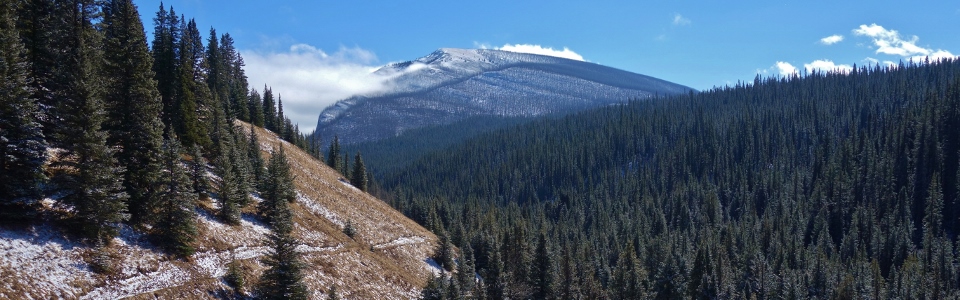
Looking back towards Mount Minos as we contoured Labyrinth’s west side aiming for slopes that, according to Google maps at least, appeared to be more open.
.jpg)
A clearing provides a view of the forested slope that eventually led most of our party to the summit. From here, we left the trail and bashed up the (much steeper than it looks) hillside. Unfortunately, the ascent to the ridge line involves a tangle of deadfall beyond which lies an unseen, but massive, field of jagged wobbly boulders. This marked the official re-shit-erizing of the ascent.
.jpg)
Crux and I call it a day at the base of the boulder field. While the deadfall was unpleasant to chart a puppy-friendly course through, the boulders would have proved impossible. It actually proved tricky enough to plot a human-friendly course through the boulders as poor So discovered, hurting his ankle on descent from the summit.
.jpg)
Fortunately Crux and I had company in the form of Fabrice and his pack (Lincoln, Rupert and Daisy) while we waited for Josée, Raf and So to return from the summit.
.jpg)
Views of an unnamed ridge to the west from our sunny hillside perch.
.jpg)
Even without bagging Labyrinth, it looks like Crux still enjoyed himself!
.jpg)
Once Josée, Raf and (a hobbled) So returned from the summit, we took full advantage of the horse trail, enjoying views of Mount Minos, as we made our way back down to the Red Deer River.
.jpg)
Although the trail supposedly goes all the way to the Red Deer River, we eventually left it once it turned north below Labyrinth’s east face since this change in direction was taking us further from our vehicles. Following a short, final thrash, we found ourselves back at the river as the evening shadows crept higher up the hillside opposite.
.jpg)
The sun sets behind Labyrinth Mountain as So gets a head-start on icing his sore ankle. Labyrinth may not ever become a classic ascent but at least now there’s some online beta on it!