Four years ago, my (then future) father-in-law Gary took Brianne and I on a fun desert scramble up Flatiron Peak during a visit to his winter stomping grounds (Apache Junction, AZ). In the four years since our last visit, a lot happened. I bagged another couple peaks (93 by my count), Brianne and I bought a house together and got married. Oh yeah – we had a baby too. Since Gary and Karen were missing their granddaughter (and since we were long overdue to pay them a winter visit), we booked a cheap airfare to Phoenix on Air Canada “Rogue”.
Officially, the purpose of our trip was for Mera to visit with Nannie and Papa. Unofficially, the trip’s main goal was to bag Four Peaks (just kidding Brianne)! When Gary took us up Flatiron Peak, those many years/summits/offspring ago, he pointed out four jagged summits that rose 850 m higher than Flatiron to the north and described “fun” scrambling to reach the summit of the highest peak in the Phoenix area. I was sold.
Although the summit of Brown’s Peak is only 35 km from Apache Junction (as the crow flies), getting to the trailhead is quite a drive! The shortest distance route is 77 km, however, this involves 31 km on a very rough road which ascends Four Peaks’ shoulder via the west (Four Peaks Road/FR 143). Another option is to take the longer route (147 km) which ascends the same shoulder via the east. The final 20 km of this route follows El Oso Road, which is a more maintained dirt road. The travel time via either route is similar despite the difference in distance! Just for fun, we drove out via Miami, AZ and El Oso Road (165 km) to avoid the Phoenix Marathon which was tying up some of the highways along the two shorter routes. Unfortunately, Brianne was unable to join us as a result of the long drive (Mera still needs to be fed by her mom every 2 – 3 hours) but we were joined by another ex-pat Canadian friend of Gary’s: Sam.
.jpg)
The postcard-worthy view of Four Peaks from just outside of Phoenix. Seriously – this view is actually on a lot of postcards (and it’s easy to see why)! (Photo courtesy of Dave Dilli Photography)
.jpg)
The sun rises above Theodore Roosevelt Lake as Gary’s trusty 4x4 tackles El Oso Road. Although the summit of Browns Peak is 1,700 m above the lake, El Oso Road takes you up 1,100 m of that elevation gain. Looks like the truck burnt more calories than we did on this day!
.jpg)
Snow on Browns Peak hints at cooler temperatures above while El Oso Road winds its way steeply up the peak’s northeast shoulder. The road was a little rough in places but I’d still take my car up it. Any higher clearance SUV/truck should get up the road without issue!
.jpg)
Three hours after we left Apache Junction, we finally reached the Lone Pine trailhead and set off along the well-travelled “Browns Trail.”
.jpg)
Initially, the trail meanders up amongst impressive granite boulders.
.jpg)
Expecting a cactus-filled outing, the flora along the trail (pine forest without a cactus needle to be found!) took me completely by surprise. I suppose I shouldn’t have been shocked given the high starting elevation and the fact that the trailhead is named “Lone Pine.”
.jpg)
Isn’t it supposed to be hot in Arizona?
.jpg)
The distinctive summit blocks of Four Peaks come into view as we approach the high shoulder (looks like we’ll have some snow to contend with up high as well).
.jpg)
A beautiful desert panorama stretches out below Four Peaks from the high shoulder. The high shoulder itself provides a great spot to take a break, enjoy a PB&J wrap and get ready for the final, steep summit push. Click to see larger.
.jpg)
Flatiron rises up above Apache Junction to the south.
.jpg)
Smog from the greater Phoenix area blankets the valley beyond Saguaro Lake.
.jpg)
Examining the route to the summit of Brown’s Peak: from the shoulder, a smattering of paths takes you to the obvious cleft in the middle of the peak. This steep scree/talus-filled gully brings you all the way to the ridge top which you can then scramble up to the nearby summit on the left.
.jpg)
Gary and Sam follow a path up from the shoulder as the going starts to become more rugged.
.jpg)
Standing on top of a small obstacle that you can climb over, or walk around (to the climber’s right), just before the entrance to the gully proper. Naturally, we climbed over! (Photo courtesy Gary Christison)
.jpg)
Of course, climbing over this small obstacle means that you have to climb back down it on the other side! As stated above, this obstacle can be avoided. A word of warning for those who choose to avoid it, however: if you don’t like the scrambling here, you REALLY won’t like the scrambling higher up in the gully!
.jpg)
Enter the gully. Time to get down to business! The first section of the gully is simply steep and a little loose; still relatively easy class 2 terrain. Since loose gullies tend to funnel rock fall, a helmet would not be out of place here. Although we didn’t spot a single person wearing one, I wish I’d brought mine.
.jpg)
The gully steepens above a large snow patch. The wall immediately above the snow is the first (and easier) of two cruxes in the gully.
.jpg)
Gary and Sam work their way up the steep snow ice. Crampons would have made quick work of this section, however, I didn’t think to bring them when packing for the 30 degree C desert heat! Fortunately, Four Peaks is popular and, with good steps already kicked, this section was essentially an icy staircase (note that icy staircases are easier to ascend than descend)!
.jpg)
The final (and main) crux of the gully: a steep wall. We ascended straight up the middle, however, you can also work your way up along moderately exposed ledges to the climber’s left. Either way will require some challenging class 3 climbing. Fortunately, the metamorphic quartzite that makes up the summit block provides some truly excellent holds which are unusually solid compared to the choss that I’m used to climbing in the Canadian Rockies!
.jpg)
Gary tackles the final move on the crux wall. The steepness of the ascent gully below is obvious from above!
.jpg)
Above the crux wall, the ridge crest (complete with scenic crags) is easily reached! From here a short scramble to the climber’s left brings one up to a false summit and then the nearby true summit.
.jpg)
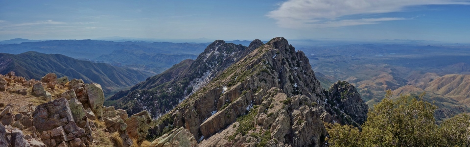
A spectacular summit panorama, highlighted by the remaining 3 peaks of the Four Peaks massif, greets those who persist up the gully! Click to see larger.
.jpg)
Gary, Sam and I on top. Sam was a genuinely pleasant fellow to hike with but, in terms of looks, this Arizona trip’s summit company was definitely a step back from last trip’s summit party (photo courtesy Gary Christison)! ;-)
.jpg)
Desert valleys to the southeast.
.jpg)
The traverse to the next peak (and beyond) looks enticing! Perhaps next time, we’ll tackle the “Motherlode”…
.jpg)
The 250 foot tall fountain goes off in Fountain Hills (a Phoenix outlier) to the southeast.
.jpg)
The panorama to the east is highlighted by Theodore Roosevelt Lake about 1,700 m below. Click to see larger.
.jpg)
A closer look at the lake. Theodore Roosevelt Lake was created in 1911 when the Roosevelt Dam was completed, damming the Salt River northeast of Phoenix.
.jpg)
The Mazatzal Mountains stretch north beyond Gary and I. The entire horizon to the right is made up by the Mongollon Rim, a 320 km-long escarpment which forms the southern edge of the Colorado Plateau. The rim is a significant biological boundary with Sierra Madre desert flora and fauna below it to the south and Rocky Mountain species to the north.
.jpg)
The Mazatzal panorama to the north. Four Peaks is the southernmost point of the Mazatzal Range. Click to see larger.
.jpg)
A final look at the spectacular three southern peaks of the Four Peaks massif before starting our challenging climb back down the gully. Click to see larger.
.jpg)
Gary tackles the first significant down climb while Sam watches on, “eagerly” waiting for his turn.
.jpg)
Down climbing the crux wall – every bit as steep as it looks!
.jpg)
Down climbing the ice below the crux wall was just as challenging as the wall itself.
.jpg)
Looking back up as another party ascends the upper (crux) wall.
.jpg)
A good look at the lower wall in the gully (from below). At this point, our troubles are over and this group’s are just beginning! As we continued down, we were greeted by many parties starting up. Four Peaks’ prominence, apparently, makes it a popular target so an alpine start is a benefit to ensure that you have the gully to yourself!
A side note: we noted that many of those who were coming up were underequipped while others were, in my opinion, over-equipped. Most of those we saw wore only running shoes which provide little support on steep, loose terrain and even less grip on icy snow! Others had no packs (and presumably no water). While 600 m gain isn’t particularly taxing, I still wouldn’t venture too far into the desert without water. Finally, a significant number of those coming up were armed (many with large knives, others with guns)! A knife could be a useful survival tool but, in my opinion, there’s no need to carry a gun on a popular hike. Looking down the barrel of a revolver pointing at me while its owner climbs above is disconcerting to say the least. You’re much more likely to be killed by rock fall in the crux gully of Browns Peak than by any animal or person!
.jpg)
With the gully above us (and my rant concluded), Sam enjoys easier scrambling back down to the high shoulder.
.jpg)
Back at the shoulder. From here, it’s cruise control back down the easy trail to the vehicle!
.jpg)
Final desert views as we hurry down. With a long drive out still ahead of us, we were keen to get back to Apache Junction where my beautiful baby girl, her mom, Nannie (and a cooler of cold beer) were waiting for us!
.jpg)
.jpg)
.jpg)
.jpg)
.jpg)