During numerous trips to Waterton, Brianne and I have enjoyed some wonderful views of Glacier National Park (GNP)’s “more impressive peaks to the south” (Alan Kane’s words – not mine!). After years of ogling these beautiful peaks from across the border, we finally packed our passports to see them up close and in-person. GNP is home to dozens of awesome scrambles but, for this visit, we decided to find a family-friendly hike to share with our baby girl Mera, her grandparents and her Auntie.
.jpg)
A family camping trip to Waterton allowed us to take advantage of our proximity to GNP to get the early start required to secure a parking spot at Logan Pass. Straddling the continental divide at 2,026 m elevation, Logan Pass is the highest point reachable by car in GNP. As such it’s a perfect starting point to explore the park’s spectacular alpine environs!
.jpg)
All geared up and ready to go! After days of downpours in AB, the sun at Logan Pass felt WONDERFUL (even if the air was still a chilly 9°C).
.jpg)
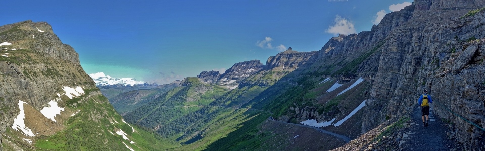
The family starts off along the Highline Trail just north of the Logan Pass parking lot. This trail is the most popular in the park and it’s easy to see why; it starts high and stays high, contouring steep hillsides and exposed ledges to keep hikers up high where the views are best!
.jpg)
Did I mention exposed ledges? ;-)
Within minutes of leaving Logan Pass, the trail cuts across a sheer headwall with an airy drop to the “Going-to-the-Sun” Road below. Click to see larger.
.jpg)
While those with vertigo may not love the 4 – 6 foot-wide ledge, it certainly provides unobstructed views of Oberlin Falls at the base of Clements Mountain! The ledge itself travels along the headwall for a distance of 300 m and features a secure wire for the safety and comfort of hikers.
.jpg)
Mera’s Nannie (wearing blue) looks more like a nanny goat on this ledge! Way to go Nannie!
.jpg)
After traversing the headwall ledge, we quickly reached the lush Garden Wall and its many small waterfalls. In the distance, Bishop’s Cap rises high above the Highline Trail.
.jpg)
Cascades keep the Garden Wall watered while “refreshing” passing hikers.
.jpg)
Wonder why it's called the Garden Wall? Rocky Mountain Columbines, for one.
.jpg)
Lewis Monkeyflowers, for another.
.jpg)
Mera and Auntie are both loving their hike along the Garden Wall. The views may be great but we’re just getting started; the Highline Trail continues to Haystack Pass (visible just above Auntie’s head between Haystack Butte on the left and Mount Gould on the right).
.jpg)
Views back towards Logan Pass amidst a proliferation of Bear Grass.
.jpg)
Beautiful Bear Grass: these unique flower stalks bloom only once every 5 – 7 years.
.jpg)
A closer look at the hundreds of miniscule flowers making up one Bear Grass stalk.
.jpg)
Another ledge – another awesome panorama! Haystack Butte and Pass are now front-and-center above the Weeping Wall. Click to see larger.
.jpg)
The Christison clan.
.jpg)
Mingling with the locals. Turns out that the Highline Trail is a great place to run into wildlife! (Photo courtesy Gary Christison)
.jpg)
More wildlife. We found this old man stretching on a rock!
.jpg)
The panorama from just below Haystack Pass provides the group with a good view of the route up Haystack Butte. The route ascends right-to-left from the pass, skirts Haystack’s formidable-looking buttress using a grassy bench below and then ascends open grassy slopes along the left-hand skyline. Click to see a larger view of the route.
.jpg)
Auntie guides Brianne and Mera across a remnant snow patch.
.jpg)
Haystack Pass: a good place for lunch…
.jpg)
…and a great place to cool off! Eat your heart out Mr. Crux! Unfortunately for Crux, dogs aren't allowed on the Highline Trail...
.jpg)
Nannie, Auntie, Papa and Mera enjoy a well-earned lunch at the pass.
.jpg)
It’s important to hydrate while hiking (even if you’ve been napping in a baby carrier all morning)!
.jpg)
Lunchtime views: Haystack Creek far below Haystack Pass.
.jpg)
Lunch with the Hobbs’. Feeding the baby in the mountains is apparently a 2 person job! I’d love to say that most of the baby food ended up in (and not on) the baby but that would be a lie.
.jpg)
Luckily there was an icy stream nearby to wash her off!
.jpg)
Haystack Pass panorama towards Logan Pass (click to see larger). After enjoying our delicious PB & Js (better than PB & Cheese apparently!), myself, Auntie and Grandpa decided to tackle Haystack Butte while the rest of our crew opted to start the 6 km return hike to Logan Pass. From here, the route up Haystack Butte follows a well-defined (for now) trail up the hill on the right.
.jpg)
From the top of the hill, Haystack Butte looks formidable! While it would be possible to scramble up through breaks in this buttress, an easy grass bench to the left provides more hiker-friendly access.
.jpg)
Wonderful hiking (and views) along a now-faint trail on the flat grassy bench.
.jpg)
Further along the bench, the rock band guarding the summit of Haystack Butte eventually disappears, giving way to steep grassy slopes that can easily be ascended.
.jpg)
Open hillside. By this point the trail is gone so just follow your nose to the summit!
.jpg)
The Old Man makes his way up Haystack Butte under the steep southwest face of Mount Gould.
.jpg)
Catching his breath just below the summit. Final push…
.jpg)
The summit crew atop scenic Haystack Butte!
.jpg)
After coming all this way, the view of the “more impressive peaks to the south” was still the highlight of our summit panorama! :-P
Click to see larger.
.jpg)
Auntie enjoys a Zen moment as the Going-to-the-Sun Highway and Logan Creek wind their way steeply up towards lush Logan Pass.
.jpg)
Logan Pass and the stunning peaks that surround it. From left to right: Mount Stimson (distant), Blackfoot Mountain (and 1 of the 25 remaining active glaciers in GNP), Reynolds Mountain and Mount Jackson (distant).
.jpg)
A closer look at the Going-to-the-Sun Highway and the airy Highline Trail ledge above as they break through the headwall guarding Logan Pass.
.jpg)
A gorgeous hanging valley nestled between Mount Oberlin (left), Clements Mountain (center left) and Mount Cannon (right).
.jpg)
The more impressive peaks may be to the south but the panorama to the north wasn’t exactly “shabby.” Click to see larger.
.jpg)
The Old Man enjoys a stellar summit view of Mount Vaught (center left) and Heavens Peak (center right).
.jpg)
The Going-to-the-Sun Road switchbacks its way down steeply towards Lake McDonald as a sea of peaks rise up beyond. From left to right: Anaconda Peak, Logging Mountain, Mount Geduhn, the four snowy summits of Vulture Peak, Rainbow Peak, Mount Carter and distant Kinnerly Peak.
.jpg)
Looking down towards an exciting section of the Going-to-the-Sun Highway.
.jpg)
Looking over the Highline Trail as it side-hills along the Garden Wall on the sheer west faces of Mount Gould (center left) and Bishop’s Cap (center right). Although these peaks appear impregnable from here, class 3 or 4 routes are present on both.
.jpg)
A father-son summit shot before starting back down (and trying to catch up to the rest of our group). It was great to bag a peak with the Old Man again!
.jpg)
Hastily making our way down the steep grassy slope.
.jpg)
Rather than hike back to Haystack Pass, we opted to shortcut directly down to the switchback below it to save some distance. One can, apparently, save even more distance by descending directly to the Weeping Wall roadside pullout on a climber’s trail. When we asked a passing ranger about this option, however, he told us that no such trail exists. I’m not sure what this link and this book are talking about then! Regardless, the climber’s trail was not obvious so we opted to continue along the more popular Highline Trail.
.jpg)
The killer rabbit of Caerbannog! Fortunately, I fared better than King Arthur’s knights when this beast attacked (my ankle)!
.jpg)
Auntie hikes back along one of many ledges. Hope there’s no wildlife blocking our way; there’s not really anyway around!
.jpg)
GNP obstacle! It’s bad enough that the goat blocked the trail but he didn’t have to stick his tongue out and taunt us! (Photo courtesy Gary Christison)
.jpg)
Logan Pass doesn’t seem to get closer no matter how far we hike back towards it! Fortunately, views like this help to pass the time!
.jpg)
Another couple of trail users. These guys look like they mean business – better get out of their way!
.jpg)
Not wanting to discover why they’re called “rams,” we hastily climbed up the steep hillside to let them pass!
.jpg)
How close did the bighorn sheep get? TOO close! Fortunately, they watched us for a moment and then bolted along the trail leaving us to down climb from our perch and resume our hike out.
.jpg)
More wildlife. Careful: this hoary marmot looks ready to pounce!
.jpg)
After successfully dodging rabbits, voles, ground squirrels, goats, sheep and a killer marmot, the rest of our hike back was scenic but uneventful. Some of the wildlife encounters were more intimidating than others but it could always be worse…
After reuniting with the rest of our group, we treated ourselves to some well-deserved ice cream in St. Mary and made our way back to the “great white north.” Ironically, our GNP peak-bagging trip didn’t lead to the summit of one of the park’s many “more impressive peaks” but the views from little Haystack Butte and the Highline Trail were stellar nonetheless!
.jpg)
.jpg)
.jpg)
.jpg)
.jpg)
.jpg)
.jpg)