For over a year now, Brianne and I have been looking forward to a toddler-less Sedona getaway for just the two of us. We love our baby girl more than anything but sometimes you just need an adult's weekend! Thanks to "Nannie" and "Papa" (who were more than happy to have Mera to themselves for a couple nights), our dream was finally going to come true!
After a short and very scenic hike on our first afternoon in Sedona, we enjoyed a dinner out (where no one got food in their hair) and settled in for a (non-animated) feature on Netflix. Eventually, we dozed off, overjoyed that we'd be able to sleep in as late as we wanted.
At 6:00 am, we were abruptly torn from our serene slumber by the piercing cry of a baby in the adjacent room. It seems that no one told the family next to us about our glorious plans for a restful morning. After attempting to fall back asleep while the parents next door struggled through breakfast, we gave up. It was 6:30 am and, adults weekend or not, we were up for the day. While it would have been nice to sleep in, I must admit that I wasn't too disappointed to be up. If you're going to bag a desert peak, it helps to start early...
.jpg)
After enjoying breakfast at the Wildflower Bread Co, we drove to Safeway for fun, then drove back to the Wildflower Bread Co and grabbed some spectacular hiking lunches to-go. After our second trip to the Bread Co in less than an hour, we finally managed to get out $hit together and made our way to the Bear Mountain/Doe Mountain trailhead just west of Sedona. The Bear Mountain trail is widely considered to be the second-most strenuous hike in the Sedona area; good thing we got that early start!
.jpg)
After crossing a desert plain for 1/2 a km (1/4 of a mile), it was time to gain some elevation! Although we were following an official trail, you can see that the going is quite steep, requiring some use of hands. By my standards, Bear Mountain qualifies as an easy scramble/strenuous hike.
.jpg)
Like other easy scrambles, you may occasionally need to use your hands. When you reach for a hold, however, you should make sure that it's not a cactus! As you can see from its missing thorns, this trailside prickly pear has been mistaken for a handhold a few too many times.
.jpg)
Prickles in her hooves. Poor Brianne - all she wanted was to sleep in!
.jpg)
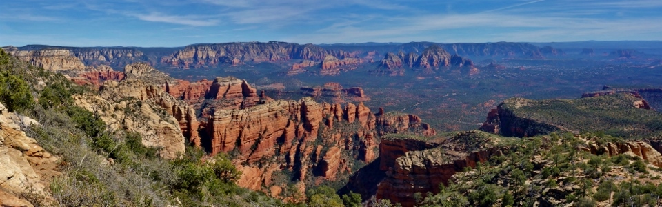
After following the trail through a break in the first rock band, the view was already outstanding!
.jpg)
Frequent (as in every 4 feet) white markings keep those with a lack of routefinding skill from wandering off into the thorny desert brush. If you're not confident in your routefinding abilities on Bear Mountain, simply follow the "white hexagon road."
.jpg)
Brianne (and her 15 week baby bump) enjoy the red rock pillars between the first and second significant cliff bands on Bear Mountain.
.jpg)
Water trickles down the second rock band. Despite appearances, the well-marked trail avoids all climbing and forges a steep but non-technical way through all potential difficulties.
.jpg)
Above the second band, the rocks changed from red to yellow and we were granted our first view of the summit (right) atop a broad plateau which features a dramatic drop to the west (climber's left). Click to see larger.
.jpg)
Brianne pauses to enjoy the view. Despite our "alpine start", it was already quite hot out so scenic lookouts like this provided a welcome chance to rest from time to time.
.jpg)
The broad plateau leading to the summit (center) of Bear Mountain. Although it doesn't look much higher, the wide-open terrain on this plateau lends itself to foreshortening. The end may not look far but we're still only halfway up!
.jpg)
The yellow rock plateau features several dips which require you to lose elevation before regaining it.
.jpg)
At the very least, however, these dips are scenic! Higher up, the plateau narrows significantly and outstanding views of Fay Canyon are revealed to the east. Click to see larger.
.jpg)
A closer look at colorful Fay Canyon. Last year, we hiked a mile up Fay Canyon with our baby girl so it was very cool to revisit this spot from above a year later!
.jpg)
What goes down the dips must go back up (and then some). A pink-clad Brianne hikes up steep yellow rock en route to the summit of Bear Mountain.
.jpg)
A bit of hands-on scrambling here and there to keep things interesting.
.jpg)
Brianne stops to pose high above Fay Canyon (and just below the summit). The final bit of the ascent is incredibly scenic (in fact it's prettier than the summit itself). Beyond the sheer red rock walls of Fay Canyon, Mount Wilson (center) and Capitol Butte (right) rise high above the surrounding desertscape. Click to see larger.
.jpg)
Of course the view from the summit isn't that bad either! After ascending a small yellow band, the trail ends atop Bear Mountain's broad summit plateau granting expansive views beyond aptly named Red Canyon to the northwest. Click to see larger.
.jpg)
Red Canyon is spectacular and it's made even moreso by a large fin of yellow rock which juts out of Bear Mountain's northwest face.
.jpg)
Roads and hiking trails mark the location of 700 year-old ruins in Red Canyon far below; another of the places we visited with our baby girl last year! Bear Mountain ended up being a perfect objective for Brianne and I this year as it allowed us to revisit both places that we explored during last year's family Sedona outing!
.jpg)
Brianne enjoys, what is likely to be, the most amazing summit sandwich of her life care of the Wildflower Bread Co! OMFG my reuben was GOOD!
.jpg)
Snow-covered Humphrey's Peak and the rest of the San Fransisco Peaks appear to the northwest. Humphrey's Peak is the highest point in Arizona and, at 3,851 m (12,635 feet) elevation, is higher than all but Mount Robson in the Canadian Rockies.
.jpg)
"Wait a minute...I think that next point looks higher..." The summit of Bear Mountain is a massive, brushy plateau which encompasses about a square mile. Although the trail ends on the plateau's southwestern peak, a quick glance at the topo map (which the state park generously provided) revealed that other points on the plateau are indeed higher. Being the complete idiot that I am, I told my sandwich-eating wife that I'd quickly explore the immediate area for photographic opportunities and then set off as fast as I could towards, what I thought was, the "true" summit.
.jpg)
After literally running through the thorny brush (there's no path beyond the southwest summit) for 15 minutes, I reached the next high point (marked 6056 feet on topo maps). As you can see, there was NO view but my GPS confirmed that I was 8 m higher than my wife (who was surely beginning to wonder where I was by now).
.jpg)
Looking back towards the "end of trail" southwest peak. I expect that you'll find an angry pregnant lady if you zoom hard enough...
.jpg)
If you want to venture beyond the end of the Bear Mountain trail to get to the "true" summit, I recommend that you wear long pants! Thorny desert bushwhacking is painful but I was, at least, able to exfoliate (and confirm by GPS that the more northerly summit was 8 m higher). 35 minutes after I left Brianne, I rejoined her on the much more scenic southwest peak. Predictably, she was less than thrilled about my sudden disappearance...
To make matters worse, a glance at more extensive topo maps after-the-fact reveals that the "true" summit of Bear Mountain was still over a kilometer northwest of the sadistic summit that I mutilated my legs upon! Indeed, the "true" summit of Bear Mountain is 3 - 6 hours beyond the end of trail on the northwesternmost-point of the massif which is so far away that it's not even shown on the topo maps that the State Park provides! To make the Bear Mountain "summit" debate even more convoluted, the end-of-trail (southwest) peak's elevation matches the official Bear Mountain elevation listed by the USGS so it's likely the "official" summit anyways! Long story short - enjoy the awesome view from the peak at the end of the trail!
.jpg)
♪ Reunited (on the southwest summit) and it feels so good! ♪
.jpg)
Expansive views south from the only summit really worth visiting. To the left, the Bear Mountain massif stretches out towards the access highway and Doe Mountain beyond. Click to see larger.
.jpg)
After an "hour"-long stay on the summit waiting for me, Brianne starts back down towards the trailhead. The rugged Bear Mountain trail follows the southeast ridge down from Brianne on the left to the desert floor below on the far right. Scenic Sedona lies beyond Fay Canyon on the right-hand-side of Mount Wilson (center). Click to see larger.
.jpg)
Brianne follows the trail down between a pair of scenic pine trees high above Fay Canyon.
.jpg)
As we continued down, the plateau's yellow rocks were replaced by the red rock of the valley below. Eventually, the road came back into sight along with familiar landmarks like distant Courthouse Butte (center), Bell Rock (diminutive - center right) and Cathedral Rock (right). Soon enough, we were back at the trailhead and ready to get back to Sedona for a celebratory steak dinner!
.jpg)
Looking back towards Bear Mountain on the drive home. You'd have to be smoking peyote to think that this mountain looks like a bear but it was an awesome hike nonetheless! Certainly well-worth the early morning!
.jpg)
.jpg)
.jpg)
.jpg)
.jpg)
.jpg)