After enduring days of heavy wildfire smoke during a recent family camping trip to Revelstoke, BC, we rejoiced at the unfamiliar sight of blue skies on Monday August 13! Enticed by the possibility of actually seeing the surrounding Selkirks, we wasted little time lacing our hiking boots. One year earlier, Brianne, Mera and I had started the “Great Glacier” hike at nearby Rogers Pass. Unfortunately, that outing proved a little much for Brianne (who, it should be noted, was 7 months pregnant), so we turned around short of the trail’s end. Seeking to finally complete our trip to the “Great Glacier” (or at least where the “Great Glacier” used to be), we enlisted our entire extended family and caravanned from Revelstoke to the trailhead at the Illecillewaet campground.
.jpg)
The hike begins by following the Canadian Pacific Railway’s original route and crossing the Illecillewaet River on a scenic stone bridge which dates back to the railway’s completion in 1885. The CPR’s original route climbed up and over Rogers Pass much like the present-day Trans-Canada Highway does. This route, however, involved steep mountain grades and exposed the railway to extreme avalanche hazards during the pass’ long winters. Despite the presence of 31 ‘snow sheds’, winter operation of the railway routinely required men to clear the track of avalanche debris. On March 4, 1910, 63 men and a locomotive-driven snowplow were deployed to clear an avalanche below Cheops Mountain. At 11:30 pm, the workers had nearly completed their task when another avalanche roared down from adjacent Avalanche Mountain. 62 of the 63 workers were instantly buried under 10 m of snow and killed. This disaster ultimately compelled the railway to abandon Rogers Pass though it was not the first of its kind. Between 1885 and 1910, over 200 lives were lost to avalanches near Rogers Pass. In 1913, the CPR began construction of the Connaught tunnel which opened in 1916, allowing the railway to pass under Mount MacDonald, by-passing Rogers Pass.
.jpg)
After crossing the Illecillewaet River, the 1885 rail-grade leads to the site where the “Glacier House” hotel once stood. As you can see, Mera was quite interested in learning about the area’s history!
.jpg)
An interpretive sign shows the old rail line, Glacier House and the, then much larger, “Great Glacier”.
.jpg)
All that remains of the once-popular Glacier House hotel. When the Connaught tunnel allowed the CPR to bypass Rogers Pass in 1916, Glacier House became more difficult to reach and visitor numbers declined. By 1925, Glacier House closed and in 1929 it was demolished.
.jpg)
Beyond Glacier House’s ruins, the “Great Glacier” trail makes its way up-valley through spectacularly lush forest.
.jpg)
Ferns line the thick forest floor, holding dew drops well into the morning thanks to the cool air and canopy overhead.
.jpg)
Mera and I model our mossy mustaches (truth be told their actually made up of lichen).
.jpg)
Grandpa playing around with his camera (no doubt attempting to blur the Illecillewaet River’s rushing water).
.jpg)
Cheops Mountain highlights the view down-valley beyond lichen-draped pines.
.jpg)
Higher up, we were able to explore the Illecillewaet’s riverbed where the flow was less vigorous. From this opening, we caught our first (and only) view of the “Great Glacier” which has now receded all the way to the top of valley.
.jpg)
Multi-tasking (hiking and photobombing) along a newer section of trail.
.jpg)
At a massive boulder field, the forest thins granting a glimpse of massive Mount Sir Donald.
.jpg)
Obsessed with the lighting, our photographing Grandpa insisted that the group pause for a picture at a forested switchback. Personally, I didn’t find the lighting here to be anything special but the photo turned out nicely at least!
.jpg)
The easy way to hike (on Mom’s back)!
.jpg)
After a couple kilometers of steady up-valley travel, the forest finally thins allowing flowering fireweed to proliferate.
.jpg)
Our little climber – there must be mountain goat blood in those veins!
.jpg)
As the trail begins to ascend the valley’s right-hand side, sublime subalpine views towards Mount Sir Donald (left) and Terminal Peak (right) are revealed.
.jpg)
Two “Old Goats” and a “Baby Bear” (I'm going to get in trouble for that caption!).
.jpg)
Mera leads the way for Auntie Jana and Uncle Craig.
.jpg)
Impressive falls cascade down glacier-scoured bedrock from the Illecillewaet Glacier and Névé above.
.jpg)
The beginning of the end: although the glacier is nowhere in sight, the “Great Glacier” trail ends just ahead of Brianne where the orange-colored rock meets the path (about 4 km from the trailhead). While there is no glacier to see from the hike’s high point, the glacier-less scenery was so spectacular that we (almost) didn’t notice. Click to see larger.
.jpg)
The dramatic beginnings of the Illecillewaet River at the foot of Mount Sir Donald.
.jpg)
Horn-shaped Mount Sir Donald towers above all else in the area. The peak’s northwest arête (left-hand skyline ridge in this photo) is considered among the top 50 climbs on the continent thanks to its excellent rock quality, aesthetic appeal and airy views.
.jpg)
My favorite climbing partners and I. Over lunch, Mera told us that she wanted to climb “that mountain” (while pointing to Mount Sir Donald). Some day we will my Love!
.jpg)
An amazing array of waterfalls cascading down the freshly exposed headwall.
.jpg)
Mera scrambles about on the wonderful rock at trail’s end (with a little help from Papa and Uncle…).
.jpg)
Auntie points out Sir Donald’s classic NW arête route to Mera as Papa and Uncle look on.
.jpg)
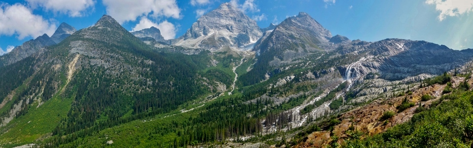
A great but glacier-less panorama! It’s hard to imagine but a little over a century ago, this entire valley was filled with ice. Click to see larger.
.jpg)
Cheops Mountain, Ursus Minor Mountain, Grizzly Mountain and Mount Sifton highlight the view down-valley towards the Trans-Canada Highway.
.jpg)
Happy to be hiking with Nannie and Papa (and Grandma and Grandpa who were scowling and taking the photo, respectively).
.jpg)
Auntie and Uncle enjoying the fresh (smoke-free!) air.
.jpg)
Grandpa putting his new hip to good use! After not being able to hike much last summer, it’s been great to have our resident photographer back on the trails with us this year!
.jpg)
After exploring the scoured rock and enjoying a lengthy lunch, we reluctantly tore ourselves away from this beautiful subalpine scenery and started back down towards the tree line.
.jpg)
Grandpa soaks up the sun and the scenery.
.jpg)
Mera and her hiking buddies.
.jpg)
Playing hide-and-seek in a stream (!).
.jpg)
The two old guys perched above the Illecillewaet River.
.jpg)
Penny attempts to solve a bouldering problem during a reprieve from her hiking carrier.
.jpg)
Big sister gives it a go as well…
.jpg)
With a little help from Daddy, Mera eventually found her way to the top of the mighty boulder.
.jpg)
Celebrating with a boulder-top can-can dance!
.jpg)
On descent, we bypassed Glacier House and walked an additional half kilometer to check out “The Meeting of the Waters” where the Illecillewaet River and Asulkan Brooks come together.
.jpg)
Bear in a chair!
.jpg)
Mera and Penny #ShareTheChair with Grandma and Nannie, respectively.
.jpg)
“Meeting of the Waters” panorama: the Illecillewaet River on the left and Asulkan Brook on the right. Click to see larger.
.jpg)
Capping the day off with an Illecillewaet family photo (thanks to my camera’s 10 second timer and some fancy footwork)!
"Great Glacier" may not actually feature a glacier but it proved to be a great hike, nonetheless!
.jpg)
.jpg)
.jpg)