Tempe Butte ('A' Mountain)
Elevation: 426 m (1398 feet)
Elevation Gain: 85 m (278 feet)
Tempe Butte is the official name for the andesite butte of volcanic origin located partially on Arizona State University’s Tempe campus. The butte’s summit is the highest point in Tempe and provides pleasant views, making it a popular hiking destination. Tempe Butte is also known as ‘A’ Mountain and Hayden Butte. The name Tempe was bestowed upon the town (and butte) as the result of a fanciful comparison to the Vale of Tempe near Mount Olympus in Greece. Those who refer to the butte as ‘A” Mountain do so for Arizona State University's 60 foot-high letter ‘A’ which adorns the peak's south face. The name Hayden Butte is a tribute to businessman Charles T. Hayden who helped found both the City of Tempe and Arizona State University.
My Ascents:
March 11 2018
Trailhead: Tempe Butte Pay Parking
With our annual trip to sunny Arizona drawing to a close, Brianne and I decided that we’d best take our little ones (and their grandparents) on a family hike before returning to the Great White North. After researching nearby baby- and toddler-friendly peaks, I presented Brianne with a ‘short-list’ of possibilities. Knowing that the Four Peaks Brewery (which we’ve been meaning to visit for years) was located in Tempe, my wife quickly (and wisely) selected Tempe Butte from this list. After all, hiking with kids can be thirsty work…
.jpg)
The family makes their way to the base of Tempe Butte as an airplane roars overhead. As it turns out, the butte is directly aligned with nearby Sky Harbor’s parallel runways making this (to my toddler’s delight), a frequent occurrence.
.jpg)
Tempe Butte is a pretty easy hike (note the paved path!) so Brianne picked up some extra “weights” for a better workout. Toddlers really do bring new meaning to the term "resistance training"!
.jpg)
Yet another flight passes overhead as the butte’s famous ‘A’ comes into sight.
.jpg)
Mera fearlessly leads the way as the going becomes a more rugged on the mountain’s upper half.
.jpg)
Like a good granddaughter, Mera helps her “Nannie” up a steeper section.
.jpg)
Hear the mighty engine roar, see the silver wing on high.
After waking up to some uncharacteristic early morning rain, clear Arizona skies made for a perfect hiking day.
.jpg)
After gaining the peak’s east ridge, the too-civilized route to the summit (and its godawful radio tower) are hard to miss.
.jpg)
Thanks to relatively new addition Penny, our family summit photo became more crowded this year!
.jpg)
Looking north, Tempe Town Lake dominates the panorama. From left to right, one can also see the Papago Buttes, Camelback Mountain, another (!) airplane, Scotsdale, Sawik Mountain, Mount McDowell (more commonly referred to as ‘Red Mountain’), and the distant Mazatzal and Superstition Mountains (still cloaked in cloud). Click to see larger.
.jpg)
Yours truly scrambling about in an attempt to get as close as possible to the actual summit (which is fenced off to keep hikers away from the godawful radio tower).
.jpg)
From the summit, an outcrop obscures the panorama to the east. Naturally, I had to explore this sub-peak to get a better view! After making my way through a cut fence, scrambling over slabs, dodging fields of broken glass (thanks college students) and passing a shady-looking fellow working on electronics, I arrived to this view highlighted by (from left to right): Tempe Town Lake, another (!) airplane, Sun Devil Stadium, San Tan Mountain, Tempe and Montezuma Peak. Click to see larger.
.jpg)
A closer look at Sun Devil Stadium, which is in the midst of a $256,000,000 renovation. The stadium is currently home to Arizona State University, was the former home of the NFL’s Arizona Cardinals and has played host to dozens of Bowl games, including Super Bowl XXX.
.jpg)
From the outcrop, Phoenix provides a backdrop to Tempe and ‘A’ Mountain’s summit.
.jpg)
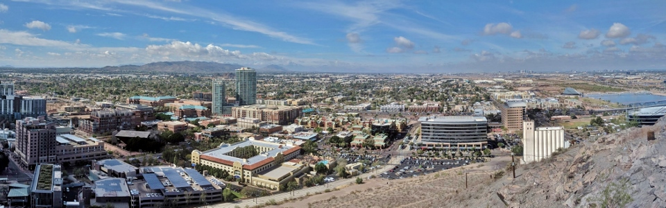
The southwestern panorama features views towards Tempe, Montezuma Peak, Hayes Peak and Phoenix. Click to see larger.
.jpg)
ASU student condos highlight the view towards Tempe.
.jpg)
The now-abandoned Hayden Flour Mill is apparent at the butte’s base. Built in 1918, this mill is a monument to Tempe’s roots as an agricultural center. Beyond the mill, downtown Phoenix’s more modern skyscrapers dot the horizon.
.jpg)
Happy hikers high above Tempe! After taking in the views, we soon realized that we’d worked up a thirst with all this hiking…
.jpg)
Apparently what goes up (Tempe Butte), must come down (to the Four Peaks Brewery)! Like I said earlier, hiking with kids is thirsty work!
Cheers!
.jpg)
.jpg)
.jpg)