Frank Slide Interpretive Loop
Elevation: 1400 m
Elevation Gain: 67 m
At 4:10am on April 29 1903, a massive block of limestone (425 m high, 1000 m wide and 150 m thick) weighing an estimated 82 million tonnes broke free from the top of Turtle Mountain and fell to the valley below at speeds reaching 112 km/h, burying the east side of the town of Frank. The Frank Slide, as the event came to be known, spread debris as far as 3 km away from Turtle Mountain and 120 m up the opposite side of the valley. The event resulted in at least 70 deaths and was heard over 200 km away in Cochrane. Prior to being named Turtle Mountain in 1880, the aboriginal people of the Crownest Pass had their own, ominous, name for the peak: “the Mountain that Moves.”
My Ascents:
June 11 2020
Trailhead: Frank Slide Interpretive Center
After a long Canadian winter (is there any other kind?), we were excited to get some use out of the camping trailer that we purchased last fall. Apart from one late September trip last year, our little home-away-from-home had spent all of its time alone at a desolate RV storage lot. An extended family camping trip would obviously be the best way to remedy that situation so, when Provincial Park campgrounds re-opened, I played “reservation roulette” online. Surprisingly, I won, netting 3 nearby camping sites for our immediate family and both sets of grandparents!
Knowing that campgrounds near Calgary would be a $hitshow, we cast our gaze further south to, relatively new, Castle Wildland Provincial Park. I am slowly learning that my wife is not a fan of 2+ hour-long drives but it seems that she’s willing to make exceptions for camping trips. I guess that means all of our camping trips this year will be ridiculously distant from Calgary!
In all seriousness, Castle PP isn’t that far from Calgary (2.5 hours) but it was just far away enough to justify stopping somewhere to stretch everyone’s legs. I suspected that there would be little appetite among our group for the typical Matt Hobbs “hike” so I decided to surprise everyone by suggesting something downright reasonable: the interpretive loop around the Frank Slide Center. At 1.5-km-roundtrip and only 67 vertical meters, this loop screams “family-friendly” and the slide itself is both fascinating and awe-inspiring. As an added bonus, the small side-trip into Bellevue/Blairmore would provide an opportunity to fill growlers at the recently opened The Pass Beer Company (when in Rome Crowsnest Pass…).
.jpg)
Turtle Mountain towers above our family’s little home-away-from-home. Mercifully, the parking at the Frank Slide Interpretive Center is RV-friendly (because I still suck at driving this thing)!
.jpg)
Starting off down the well-marked loop, we were quickly granted views east towards the town of Bellevue (which narrowly avoided the town of Frank’s fate).
.jpg)
.jpg)
LEFT: Brianne and Penny enjoy a peaceful stroll through, what was once, an 82 million ton rock located some 900 m above and 3-km-distant. For those looking to get the most out of the impressive scenery on this little loop, I’d recommend hiking it in a clockwise direction (since this keeps the slide in front of you rather than at your back).
RIGHT: The grandparents enjoy a family hike with their 3 “grandchildren.”
.jpg)
An opportune spot for a family photo. Pity our children aren’t more cooperative (we took a dozen photos and this was as good as they got…) KIDS…
.jpg)
Tout la gang. As I struggled to prop my camera up on a jagged boulder for a self-timer shot, a friendly passerby ignored coronavirus protocol and offered to take the photo for me. I happily accepted and then sanitized the crap out of my hands and camera once they were out of sight! 🤣
.jpg)
.jpg)
LEFT: Like father, like daughter! Mera spotted an appealing boulder and immediately insisted upon scrambling up it. Who am I to say no that?
RIGHT: Kings of the “castle” (take that dirty rascals)!
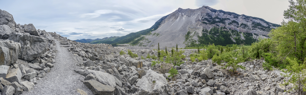
.jpg)
Where once a town had been. An impressive panorama from the debris field that now sits at Turtle Mountain’s foot. Click to see larger.
.jpg)
Coaxing kids, dogs and grandparents along the expertly crafted trail.
.jpg)
To the west, Phillips Peak, Mount Tecumseh and Mount Erickson are framed by lichen-laden limestone.
.jpg)
Numbered signs abound along the loop and are, no doubt, part of some self-guided tour available through the nearby interpretive center. We had no literature to inform us as to their significance but that didn’t stop the girls from marveling at each and every one of them. In fact, I think they were the highlight of Mera and Penny’s day! “I found a sign! I found a sign!”
.jpg)
Unfortunately, what goes down, must go back up. Since this trail (uncharacteristically) started by descending, it finished with an unnecessarily well-marked ascent.
.jpg)
.jpg)
LEFT: Speed Demon! (“I not a demon – I just Penny Jean Hobbs!”)
RIGHT: Mera helps Grandma up over some roots.
.jpg)
Nannie and Papa are all-smiles as they complete the 1.5-km loop. Actually, Papa is probably smiling because he knows that the next planned stop is at the nearby The Pass Beer Company! 🍻
.jpg)
Okay – maybe the numbered signs from the self-guided tour weren’t the number 1 highlight of the girls’ day. What would camping be without marshmallows?! Don’t burn ‘em Goat!
.jpg)