Mount St. Helens is physically, historically and geologically awe-inspiring. Simply looking upon the stratovolcano’s massive crater, its collapsed face and the wasteland that stretches away from its northern foot is a humbling reminder of nature’s power and our own smallness.
When I started scrambling many years ago, one of the pastime’s primary lures was this reminder of smallness. The awe that one feels atop a mountain when the surrounding world falls away at your feet and its true scale, relative to your own, become imminently apparent. This moment is euphoric and spine-tingling and proved addictive. Before adventure, summit tallies, novel ascents and ego became personal drivers, it was this strange need to be awed; to feel small that drove me up mountains. Of course, as with any addiction, a bounty breeds tolerance and, over the years, as I stood atop more and more mountains, those small but euphoric moments became harder and harder to duplicate.
In late June 2022, my work sent me to Seattle for 4 days of meetings and symposia. Motivated by a desire to explore new surroundings and my never-ending compulsion to pad my summit tally, I decided that I’d attempt one of the nearby Cascade volcanoes “while I was in the neighborhood.” Of these, St. Helens proved the most appealing owing to its infamy and the fact that it can be climbed in a single day. When climbing permits for June, 2022 became available on May 1, I secured one and circled June 29, 2022 on my calendar: ascent day!
.jpg)
Arriving in Seattle, I was excited to be met by warm summer weather and blue skies ☀️. These proved perfect for visiting the local tourist traps and attending parades 🏳️🌈 when my day’s work obligations were fulfilled. Better still, they also suited me just fine for my scheduled date with St. Helens! In the weeks leading up to June 29, I’d monitored the mountain’s conditions and discovered that the usual summer route up Monitor Ridge remained closed due to lingering winter conditions. This wasn’t a huge concern as I’d come prepared with an ice axe, mountaineering boots and crampons (note to self: ice axes are not allowed in carry-on bags)! It did, however, mean that I’d have to climb the “Worm Flows” winter route (which requires 1810 m elevation gain vs. the standard summer route’s 1380 m). This, combined with winter conditions on much of the mountain, meant that I’d be in for a potentially LONG day (especially when one factors in the 3.5-hour drive from Seattle 🤔😬)…
.jpg)
To maximize my chances of a successful summit, I therefore decided to leave Seattle in my rental car at 1:30 am (after a restless 3 hours sleep). Driving down the unfamiliar I-5 in the dark, I had to remain alert as I passed through one rain squall after another. The forecast had called for clear, sunny skies so things weren’t exactly proceeding according to plan at this point 😣. After leaving the I-5 behind, I enjoyed the winding race car track that is Highway 503 (more amusing still when it’s pitch black out) before eventually following Forestry Service Road 83 to the Marble Mountain Sno-Park (which serves as the trailhead to the Worm Flows route). By the time that I geared up, ate my 2nd breakfast and signed into the climbing register, dawn had just broken and I could, for the first time, see my surroundings.
.jpg)
As I embarked, it was just light enough to keep my headlamp in my pack while navigating the well-marked trail through 3.5 km (2.1 miles) of forest.
.jpg)
.jpg)
LEFT: Making quick work of the approach hike thanks to the road-like trail.
RIGHT: Still well-below tree line, I encountered the first snow of the day ❄️ – a harbinger of things to come!
.jpg)
As I neared tree line, I reached the drainage where “Chocolate Falls” would normally be. On this day, however, the water was still frozen above (not flowing below). Typically, this spot would provide the day’s first view of Mount St. Helens itself but unforecast overcast skies meant that the peak was completely obscured by cloud ☁️. Again, not exactly the start I’d been hoping for!
.jpg)
.jpg)
LEFT: Small wildflowers near tree line provided a splash of color on an otherwise gray morning.
RIGHT: After crossing the “falls” (nary a trickle on this day), the “Worm Flows” at least came into view. These old lava flows are, apparently, named for their worm-like appearance and the route follows one of their crests up into the cloud.
.jpg)
.jpg)
LEFT: While the trail became less well-defined (ie: it was no longer a road) above tree line, it continued to be very well-marked.
RIGHT: Behind me, it became clear that the sun was attempting to burn through the abundant cloud over ⛅. For now, however, its efforts proved futile.
.jpg)
Small breaks in the cloud cover hinted at a mountain of some magnitude above but much of it was left to my imagination.
.jpg)
.jpg)
LEFT: The only color in these clouds…
RIGHT: Above 4,800 feet (1,460 m) elevation, a valid climbing permit is required to continue. From the looks of things, these are a coveted item. Despite issuing 110 permits per day, online forums teem with dozens of last-minute requests. Luckily, I’d planned ahead and secured mine nearly 2 months earlier. The downside of this, however, is that good weather can, obviously, not be assured for your permitted ascent day…
.jpg)
Venturing into the cloud in the permitted zone, visibility was limited. At this point, I began to catch up with other parties who had started earlier. Thanks to whiteout conditions, however, I often heard them before I saw them!
.jpg)
Climbing “Worm Flows” in a cloud. Not the conditions I’d hoped for but still better than a day in the office!
.jpg)
As I continued up, up, up into the swirling mist and past other parties, a strange thing happened. It began to get lighter 🤔. Sensing a possible break in the widespread cloud, my pace quickened and, in a seemingly miraculous moment, the upper mountain suddenly appeared before my eyes (and beneath blue skies)! 😍
.jpg)
As I broke through the clouds near the seismic monitoring station at 1,900 m/6,200 feet elevation, the cloud covered Pacific Northwest was suddenly laid about at my feet 😲. Only distant Mount Hood was visible above this ocean of white. After a dark and dreary morning, it felt like the sun was kissing me. In a word, the moment was EUPHORIC. Seeking to extend it, I set my pack down for a rest and enjoyed my third breakfast of the day here.
.jpg)
.jpg)
LEFT: Fueled by awe (and a third breakfast 😉), my pace quickened again and I passed group after group on the old lava flows.
RIGHT: Catching up to another group as the route transitions onto snow/remnant glacier.
.jpg)
Another climber toils up the snow/ice as Mount Adams makes its spectacular 😍 first appearance 55 km (34 miles) to the east.
.jpg)
.jpg)
LEFT: A small crevasse suggests that the glacier up here may not be completely benign. Fortunately, this was easily avoided (and even marked with rocks on its uphill side to prevent glissaders from sliding into it on descent).
RIGHT: A steep roll at the top of the lava flow. I’d read that there is no significant avalanche danger on this route but this aspect is clearly steep (and convex) enough to slide. Thanks to consolidated, sun-baked summer snow, this was, fortunately, not a concern on this day.
.jpg)
Passing another group as I prepare to tackle the day’s steepest terrain. At some point, someone made a joke about my pace and I explained, only half-joking, that my rental car needed to be back in Seattle by 4:00 pm.
.jpg)
Above the steep roll, the Monitor Ridge route finally came into view. While this is the usual summer route, it was obviously not in summer condition yet!
.jpg)
About 200 m (650 feet) below the crater rim, the Worm Flows route met up with Monitor Ridge.
.jpg)
Having finally reached the crater rim, another group starts to follow it north towards Mount St. Helens’ now 42-year-old summit (the former one having been 401 m higher prior to being sent into the atmosphere).
.jpg)
Looking north along the crater rim’s sizable cornice. Those who wish to avoid a long fall are advised to stay well back. Footprints, however, suggested that some remain oblivious to the shortcut down upon which they’ve stood… 🤦♂️
.jpg)
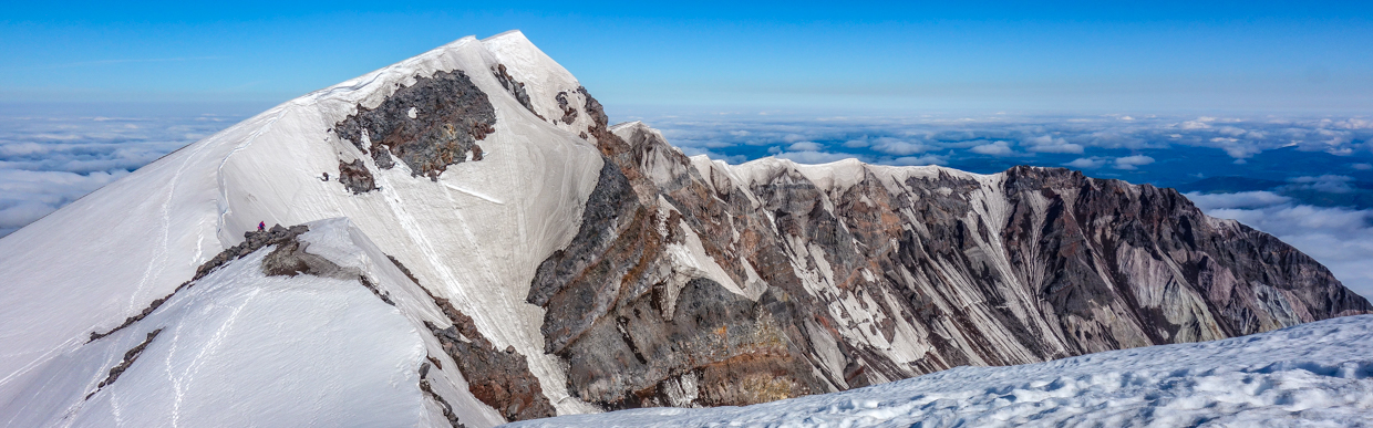
Continuing along the rim to the north (and giving the cornice a wide berth), the summit, its sizable cornices and the spectacular, crumbling crater below came into view within 5 minutes of leaving Monitor Ridge. Click to see larger.
.jpg)
Most online sources refer to St. Helens as a mere walk-up so I was somewhat surprised (and intimidated 😕) by the sight of its summit (which featured steep snow and ice, a sizable cornice and a mildly daunting downclimb). In these conditions, the finish was an alpine endeavor not a simple walk-up! I briefly wondered if the micro-spikes on my boots would be sufficient (and kicked myself for leaving my crampons in my hotel room). Only somewhat deterred, I decided to take it one step at a time since this strategy has paid many summit dividends over the years.
.jpg)
Scrambling down into the dip between the false summit and the true summit, there was a break in the omnipresent cornice which granted a view of the spectacular crater below 😍🤯. The downclimb ended up looking much worse than it actually was but it proved sufficient to deter the vast majority of the day’s 110 permit-holders! Under normal circumstances, a view like this might be the impetus for another euphoric mountain moment but, at this time, the adrenaline from my downclimb drowned out any scenery-induced dopamine 😂.
.jpg)
Same scene as above (only somewhat marred by the sight of yours truly)!
.jpg)
A closer look at the crater and the field of devastation below it. In the foreground, St. Helen’s current lava dome can be seen, literally, steaming its way through the crater’s glaciers 😮. Beyond, desolate lahar fields lead towards Spirit Lake. On May 18, 1980 this lake bore witness to a 260 m (850 foot)-tall wave as the full force of the landslide/eruption, essentially, emptied it. Even today, the lake is famous for the thousands of logs that float in vast mats upon its surface. These logs were trees that were uprooted and flung by the eruption’s cataclysmic blast wave. Beyond the lake, the next-nearest Cascade volcano, Mount Rainier, makes for an impressive backdrop above the clouds.
.jpg)
Down in the dip and making my way up the final corniced slopes to the summit. Above, another climbed can be seen descending. As far as I could tell, he, myself and one other were the only ones who made it all the way to the summit this day. I’d initially been worried about having to share St. Helen’s small summit with 109 other permit-holders but the alpine nature of the final ascent proved very effective when it came to keeping casual wanderers at bay!
.jpg)
Woohoo 😀! A successful summit selfie at 9:30 am. Time for fourth breakfast 🤔?
.jpg)
The panoramic view south, over an ocean of cloud 🤩, towards Mount Hood. Click to see larger.
.jpg)
A closer look at spectacular Mount Hood, some 100 km (60 miles) to the south in Oregon.
.jpg)
To the north, much of the panorama was obscured by cloud and cornice (although Mount Rainier was just visible over the latter). Click to see larger.
.jpg)
What could be seen of the crumbling crater walls beyond the cornice. Interestingly, St. Helens’ modern summit elevation was measured at 2,549 m (8,363 feet) following its eruption in 1980 but it appears to be nearly 10 – 20 m (33 – 66 feet) lower today!
.jpg)
A closer look at the tallest of the Cascade Volcanoes, Mount Rainier, 50 km (30 miles) away.
.jpg)
A scenic spot for a snack! I wasn’t kidding about 4th breakfast 😏!
.jpg)
Looking south and east towards Mount Adams (left) and Mount Hood (right).
.jpg)
After enjoying 30 minutes of, unexpected, solitude (and a spectacular chocolate muffin) atop Mount St. Helens, I readied my axe for the climb back down into the dip…
.jpg)
Thanks to the lack of cornice in the dip, it offered, perhaps, the day’s best panorama. Click to see larger.
.jpg)
Another look at the crater of contrasts: glaciers and lava!
.jpg)
.jpg)
LEFT: Looking beyond the fuming lava dome, over the log mats on Spirit Lake towards massive Mount Rainier. 😍
RIGHT: Impressive bergshrunds immediately below the dip in the crater.
.jpg)
As I made my way back up and over the false summit, I started running into other people again. Some, like these two, seemed quite content to enjoy their scenic perch atop the cornice 🤨. At least they responded favourably when I suggested that they take a few steps back! You can always learn from a mistake (unless it happens to be your last one)…
.jpg)
.jpg)
LEFT: Remember when I said that I climb mountains like St. Helens for euphoric moments of grandeur? For the sense of feeling small? For the summit tally and sense of accomplishment? For the adventure? Yeah, scratch all of those. I climb mountains like this for the OTHERWORLDLY glissade down 🙌!!! Once I’d made my way back along the rim to Monitor Ridge, there was literally 800 vertical meters of uninterrupted snow to slide down! On ascent, it took me 100 minutes to cover this ground. On my (very cold) butt, it took me a mere 25 minutes 😄!
RIGHT: Thanks to my high-speed, a$$-numbing descent, I soon found myself back down at cloud level.
.jpg)
Looking back up at the glissade of a lifetime! Had it not been for my rental car being due back in Seattle by 4 pm, I might have climbed this sucker again just to go back down 🤣!
.jpg)
.jpg)
LEFT: At the bottom of the Worm Flow, I gambled somewhat and stayed in the snow-filled gully rather than retracing my steps on the trail atop the flow’s crest. From the number of random rocks that sat atop the snow, there was some obvious rockfall hazard here but, overall, the route worked well and expedited my descent.
RIGHT: As noon approached, the majority of the morning cloud dissipated, allowing for views of Mount Hood even once I neared tree line. From the tree line down, I continued making haste and jogged the whole way. After ignoring a sore knee for about an hour 😣, I reached my rental car 7.5 hours after I’d left it and 3.5 hours before it was due back in Seattle (note to self: Budget car rentals don’t allow afterhours drop-offs even though their website suggests that they do)!
EPILOGUE: Somehow, someway, I managed to get that darned rental back into Seattle 10 minutes before they’d have charged me for a second day 🙃. More impressive still, I managed to do so without falling asleep at the wheel 🥱 (1:30 am wakeups and 1,800 vertical meter days can take the wind out of your sails 😂)! A celebratory burger (and several local craft beer) followed in short order; A fitting cap to a day filled with adventure, awe and many, many, many breakfasts 😁.
.jpg)
.jpg)
.jpg)
.jpg)