With spring gradually encroaching on southern Alberta, visions of summits began to dance in my head. Encouraged by warm weather and long spring days, Matt Clay and I excitedly discussed potential peaks, hoping to climb something big and dry. After months of snow and cold, we were eager to finally leave our winter gear at home! With Sunday April 24 identified as a mutually agreeable day to get out, we dreamed of prairie crocuses, dusty scree and warm sunshine. Then it happened ❄️. Calgary and the nearby Rockies got walloped with a series of record snowfalls between April 19 – 22.
So much for a nice spring scramble 🙄 …
Fortunately, neither Matt C. nor I are smart enough to call off an outing on account of record snow. Finding a suitable mountain, however, proved difficult given the rapid change in conditions. After discussing many potential peaks ad nauseam, Matt C. casually mentioned that the “lower half of Thunder Mountain was dry” which was good enough for me 🤷♂️! Knowing that the upper half was, most assuredly, not dry, we left Calgary at the uncharacteristically late hour of 7 am to give the summit some time to melt. After getting lost on my way to Matt C.’s house (I’d never been there during daylight hours lol 🤣), we enjoyed a wildlife-filled Sunday drive through the foothills to the Old Man River Gap.
.jpg)
Joined by Matt’s wife Sandra, we started up from the obvious roadside pullout towards Thunder’s north ascent ridge. Smart hikers would venture to the climber’s right here to easily gain the ridge. We, of course, did the opposite and followed a well-established “sucker trail” into the woods on the left… 🤦♂️
.jpg)
.jpg)
LEFT: Matt C. demonstrates why they’re called “sucker trails.” 😂 While the trail in the woods was fine initially, it soon started up some very steep, north-facing terrain which was either frozen solid or just-plain ice-covered. The absurdity culminated as the “sucker trail” neared the ridge crest (which we should have easily followed up from its base). Here, a thin, snow/ice-covered ledge provided the only break in an, otherwise, impenetrable rock band. After cautiously kicking steps across the ledge 😬, we gratefully regrouped on the ridge crest and vowed not to descend the way we’d come up!
RIGHT: While the lower part of Thunder Mountain may have been dry days earlier when Matt C. first mentioned it, that was clearly no longer the case. To make matters worse, the ridge’s north-facing nature meant that all of this snow was rock hard and icy. My microspikes made relatively quick work of this slope but Matt C. and Sandra’s traction devices had dulled after much use and they looked like Bambi on ice here. Unable to ascend this simple slope, we debated abandoning our ascent. Fortunately, this proved unnecessary as some poking about revealed a more gently-angled alternative that Matt C. and Sandra’s microspikes could handle further to the east.
.jpg)
After taking different routes through the deep snow and ice, we reunited atop a significant plateau on Thunder Mountain’s north ridge. The plateau offered wonderful views down over the Oldman River and granted us a welcome reprieve from the cool shade on the steeper, forested slopes below.
.jpg)
The plateau also offered a good view of the snow-covered devilry 😈 to come en route to Thunder’s false summit (which obstructed the view of the true summit from here).
.jpg)
After enjoying easy travel and a snack on the plateau, the terrain steepened and the snow deepened once again. Here, we were fortunate that a large group had ascended the day prior. Their broken trail weaved oddly and unnecessarily from side-to-side but was, nevertheless, much easier to follow than plowing our own trench through the knee-to-hip-deep snow!
.jpg)
Fresh bear tracks suggested that we weren’t the only ones taking advantage of the trail that the previous day’s group broke! Yo Bear! 🐻
.jpg)
.jpg)
LEFT: Continuing up the ridge past photogenic dead trees towards the false summit.
RIGHT: The ridge offered many natural slip-and-slides down to the Old Man River. We obviously took care to avoid these.
.jpg)
As the false summit neared, the terrain once again steepened. Matt C., who had already scrambled Thunder several years ago, recalled a crux on this section that exceeded his risk tolerance, requiring a by-pass. With this in mind, we continued up wearily, wondering how feasible either the crux or the by-pass would be given the recent snowfall.
.jpg)
.jpg)
LEFT: Sandra cautiously tackles a snow arete. Not pictured here is the dizzying 😵 runout to her right…
RIGHT: Looking up at the crux. This scramble culminated in a few meters of travel atop a knife edge ridge which offered disconcerting exposure to both sides. I elected to scramble up while Matt C. and Sandra by-passed on steep snow slopes to the east. I am confident that my route was safer (the holds were solid) but the east detour was most certainly easier psychologically. The crux wasn’t awful on ascent but I elected to follow their detour on the way down.
.jpg)
Looking back along the crux section of the ridge (a good place for blinders).
.jpg)
Mellower terrain and improving views near Thunder Mountain’s false summit.
.jpg)
From the false summit, we were finally granted a view towards our ultimate objective and noted that the ridgetop route continued to look a little unnerving. Following in the previous party’s footsteps, however, we continued up.
.jpg)
.jpg)
LEFT: While the broken trail greatly eased our ascent in most places, we had to be mindful not to follow it blindly. In a couple of places, this group had very obviously walked out on the cornice 🤯 ☠️! I probed here with my pole to be certain and found no evidence of solid ground beneath their prints!
RIGHT: Matt C. looking pleased now that the broken trail is back off the cornice and back on the ridge crest!
.jpg)
Thunder Mountain’s sunny 🌞 summit within striking distance. Still looking a tad wintry though…
.jpg)
.jpg)
LEFT and RIGHT: Matt C. and Sandra tackle the final, steep slopes up to the summit.
.jpg)
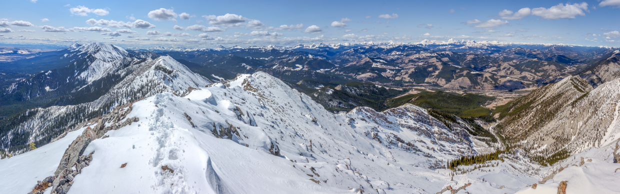
From the summit, the panorama stretched from the still-snowy peaks of the High Rock Range (left) to the rolling Porcupine Hills (right). Click to see larger.
.jpg)
Tornado Mountain (left) is one of the High Rock Range’s more impressive peaks.
.jpg)
Looking north towards the headwaters of the Old Man River.
.jpg)
The snowy quartet of Mount Livingstone, Coffin Mountain, Saddle Mountain and Sheep Mountain rise up to the left of more proximate Thrift Peak.
.jpg)
Thunder’s summit is home to an eyesore communication tower. While this infrastructure marred the summit view, it at least provided shelter from the wind and a comfortable place to sit!
.jpg)
To the south, the remainder of the snowy Livingstone Range rose sharply above the foothills and prairies. Click to see larger.
.jpg)
To the southeast, Antelope Butte and Unnecessary Mountain are a couple of foothills that only Matt C. would bother to climb. 😝
.jpg)
The Old Man Reservoir 35 km or so to the southeast.
.jpg)
Thanks to clear skies, Chief Mountain (left) was visible just across the US border some 115 km away.
.jpg)
Looking south towards Waterton National Park, Castle Provincial Wildland and beyond. Among the sea of snow-capped peaks, Mount Cleveland (center left), Victoria Peak (center) and Windsor/Castle Mountain (right) are apparent.
.jpg)
Livingstone, I presume.
.jpg)
Centre Peak (left) and Lightning Peak (center) are the next named summits south along the Livingstone Range.
.jpg)
Looking southwest towards the Flathead Range.
.jpg)
Matt C. and Sandra venture towards a western outlier which offered slightly better views of the more imposing peaks in that direction.
.jpg)
Sandra poses atop the western outlier. This outlier appeared to be about 1 m lower than the summit but was, nevertheless, home to a recently-placed memorial summit register.
.jpg)
.jpg)
LEFT and RIGHT: Obligatory register entry and selfie.
.jpg)
Thunder Mountain’s highlight western panorama, stretching the length of the High Rock Range. Click to see larger.
.jpg)
.jpg)
LEFT: Looking southwest towards the Crowsnest Pass area.
RIGHT: Evidence of why it’s best to avoid steep snow slopes after spring storms!
.jpg)
A closer look at spectacular Crowsnest Mountain and the Seven Sisters.
.jpg)
A quartet of prominent peaks directly to the west. Of these, only the left-most (Racehorse Peak) appears to be named.
.jpg)
Mount Erris.
.jpg)
The view of Tornado Mountain proved so nice that I decided to feature it twice.
.jpg)
Outliers of Tornado Mountain rise up to the left of Sugarloaf Lookout with Mount Lyall and Beehive Mountain visible to the right.
.jpg)
.jpg)
LEFT and RIGHT: The summit monstrosity/thing-a-ma-bob. I’m somewhat perplexed as to why 3 different video cameras are required to monitor this contraption? 🤷
.jpg)
As our enjoyable summit stay neared its end, we arranged for a quick 10 second timer photo and prepared to bid adieu to Thunder Mountain.
.jpg)
.jpg)
LEFT and RIGHT: Sandra and Matt C. begin their descents of the steep summit block (Sandra obviously doing so more epically 😎).
.jpg)
Retracing steps down the long ridge towards the false summit (photo courtesy Matt Clay).
.jpg)
Sandra minds her steps on a steep section. The ridge was never especially unnerving but we couldn’t simply plod down it either.
.jpg)
Gould Dome, scenically framed by rocky outcrops. Views 📷 like this and narrow sections 😬 conspired to slow our descent.
.jpg)
Fine views north from the false summit included Thrift Peak, the Old Man River Gap and the remainder of our ascent/descent ridge.
.jpg)
.jpg)
LEFT: Looking back towards another group on the summit.
RIGHT: Sandra tackles the steep, now-slushy, crux by-pass on descent.
.jpg)
Down, down we go…via a snow arete now.
.jpg)
As we tired, we began to grow weary of Thunder’s long north ridge. Eventually, we returned to its substantive plateau where we enjoyed our third lunch of the day and a brief respite before resuming our descent.
.jpg)
.jpg)
LEFT: Sandra pauses next to one of the plateau’s cool glacial erratics. From here, we should have continued to follow the ridge crest down, however, Matt C. wasn’t keen on descending the icy section in the forest that nearly stopped our ascent. He, therefore, suggested that we descend farther to the west where snow was less likely to accumulate in the afternoon sun. He even had a GPS track from his earlier trip up Thunder Mountain which followed this line so we agreed to follow him…
RIGHT: What happens when you mindlessly follow a GPS track instead of paying attention to terrain that is becoming more serious… 😝 Ironically, this is one of Matt C.’s biggest pet peeves in the mountains! After negotiating a few more-difficult-than-necessary sections, we found our way back to the ridge crest without incident and followed it easily to its base (even avoiding the “sucker trail” we’d followed to start our adventure 🥳).
In the end, Thunder Mountain didn’t end up being the dry, spring hike that I’d dreamed of but it proved to be the snowy, shoulder-season summit that I needed (and a fine way to kickstart the 2022 scrambling season)! It’s adventure time in the Rockies once more. 😆
.jpg)
.jpg)
.jpg)