Cerro Colorado
Elevation: 360 m
Elevation Gain: 250 m
Cerro Colorado is a small peak near Land’s End in Baja California Sur. “Colorado” means “colored” in Spanish and although the peak’s coloration is hardly unique for this area, this is the presumed source of its name. The peak is also known as Cerro de Las Antennas and Cerro de Las Torres as a result of the myriad of communication towers that adorn its apex.
My Ascents:
January 20 2023
Trailhead: Via la Paloma Roadside Pullout
Migration is a natural phenomenon that involves the seasonal movement of a population from one region to another. There are many reasons that animals migrate (food, breeding etc.) but, most often, they do so in search of better conditions. Having failed to find suitable conditions to allow for a winter hike with my family, I therefore proposed an aviation-assisted migration south to the warm hills of Baja California Sur! 🌞🌵
In Baja, we found a dry, temperate climate that was much to our liking. Food sources were ample/amazing and breeding opportunities… well, we already have 3 kids, so enough of that nonsense! 🤭 Most importantly, conditions were ideal for hiking! With an eye towards bagging 4-month-old Lillian’s first peak, we therefore set our sights on Cerro Colorado which rises up several km to the east of Cabo San Lucas!
.jpg)
.jpg)
LEFT: After finding roadside parking where the pavement ends at the top of Via de La Paloma, we set off on foot, following a dirt road towards Cerro Colorado’s tower-topped summit.
RIGHT: 7-year-old Mera and 5-year-old Penny may well be the cutest hikers this side of the Tropic of Cancer.
.jpg)
.jpg)
LEFT: Like geese migrating in formation, Mom (and Lillian), Mera and Penny hike towards the peak ahead.
RIGHT: To make this migration a complete family affair, we were joined by Grandma (also known as “Poncho Vieja”) and Grandpa (who was probably around a corner taking a photo at this moment). Apparently, Grandma is allergic to sun and temperatures exceeding 20 C. 🙃
.jpg)
.jpg)
LEFT: Dessert flora. 🌵 Much less benign than the lodgepole pine forests we’re used to hiking through back home. Fortunately, Cerro Colorado requires no bushwhacking thanks to the maintenance road which leads to its tower-topped apex.
RIGHT: Lillian (aka “Chillian”) may be the world’s easiest and most awesome baby 👼… BUT, she does not like being in a carrier for some reason! 😭 Fortunately, we were in no rush so there were plenty of chances to take her out for breaks.
.jpg)
Land’s End and a cruise ship came into view as we gained elevation.
.jpg)
Rock designs adorned the Cerro’s sub-summit plateau. This spot is either used as an alien landing zone 👽 or frequented by hikers with a taste for peyote.
.jpg)
Having avoided extraterrestrials and cactus-derived hallucinogens, we set our sights on the, now, nearby summit.
.jpg)
.jpg)
LEFT: Final steps towards the top under the increasingly merciless tropical sun. 🥵
RIGHT: Normally, “X” marks the spot but on Cerro Colorado “Tower” marks the top!
.jpg)
The myriad of communications towers and infrastructure atop the Cerro marred the summit view but it did, at least, grant shade! Unfortunately, the equipment does not appear to be well-maintained (there are literally fallen towers strewn about). As a result, Brianne wasn’t thrilled about lingering here and our lunch stop was very, very brief!
.jpg)
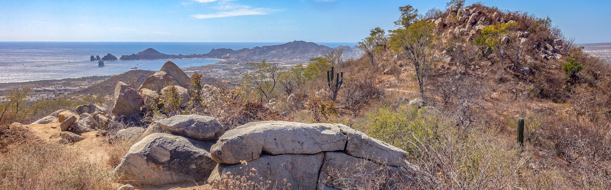
If you’re able to ignore the tumbling towers and power lines, Cerro Colorado’s summit provides a reasonably impressive Baja panorama which stretches from the Sea of Cortez (left) to the Pacific Ocean (right). Click to see larger.
.jpg)
Looking southwest towards Cabo San Lucas.
.jpg)
A closer look towards Mount Solmar and Land’s End. Unfortunately, the cruise ship in the bay blocked our view of the famous Los Arcos at the peninsula’s southern tip.
.jpg)
While the southward summit view featured water, water everywhere, a look to the north revealed not a drop to drink. There were, however, other peaks including nearby Cerro Rincon de los Sanchez (left), Cerro de en Medio (center), Cerro la Chinche (right background) and Cerro El Cenicero (distant right). Impressively, the latter rises up over 1,000 m above the surrounding sea.
.jpg)
.jpg)
LEFT and RIGHT: After a hurried lunch and a quick summit photo of my girls between towers, we beat a hasty retreat with visions of cold drinks dancing in our heads!
.jpg)
As we descended, we found that the panorama from the sub-summit plateau was actually better than that from the detritus-littered peak. No wonder the aliens land here! Click to see larger.
.jpg)
I didn’t find any aliens on the sub-summit plateau but the jury is out on whether or not “Grumpo” Gord is a peyote enthusiast… 🤔
.jpg)
While we took photos from the plateau, the cruise ship finally began to move, granting us our first view towards the famous Los Arcos. Of course, the view of the arch is better from close by…
.jpg)
While Gord and I took photos, our girls continued their steady descent.
.jpg)
A scenic overlook (which was probably my favorite view of the day).
.jpg)
Hiking with 3 kids is an involving affair and I realized on the way down that, in the Cerro-top chaos, we didn’t get a group photo (or even a photo of Lillian atop her first peak)! While the girls were keen on getting down and cooling off, I managed to convince them to stop for a quick family photo so that we’d have at least one picture together to remember our day! Once the photo was taken, our descent accelerated as the novelty of the relentless Baja sun wore thinner.
.jpg)
.jpg)
LEFT and RIGHT: The best way to cool off after a hot hike! 👙🩳 Go Goat!!! (You know Brianne is hot when... 😂)
.jpg)
.jpg)
LEFT: There’s the summit baby: Senorita Lillian! 🥰 While I forgot to get a picture of her on top, I couldn’t help but take a few extras of this little cutie poolside when we got down.
RIGHT: Hmmm. The pool proved refreshing, but I was wrong in my caption earlier. THESE are the best way to cool down after a hot Baja hike! 🍻 With a fridge-full of these, we soon found ourselves “migrating” to the patio to rehydrate and celebrate little Lillian’s first summit high over the Sea of Cortez! 🥳
.jpg)
.jpg)