Mount Carthew
Elevation: 2636 m
Elevation gain: 1000 m
William Morden Carthew was R.W. Cautley's assistant in the Dominion Land Survey and climbed the mountain as part of the survey. He was killed in France in 1916.
My Ascents:
August 22 2010
After a long traverse of Akamina Ridge the day prior, most of our group was not overly keen on another 20 km day, particularly given the forecast for rain. Luckily, there was 1 other person crazy enough to brave the elements with me and make the most of our weekend down in Waterton!
.jpg)
Some tourists taking in Cameron Lake in the rain.
.jpg)
About 10 minutes into the hike, the rain stopped, and the skies cleared. After trudging through forest for about 45 minutes, we were rewarded with a beautiful view of the curiously named Summit Lake.
.jpg)
Summit Lake, ironically, nowhere near a summit.
.jpg)
Looking south into the United States.
.jpg)
More impressive peaks?
.jpg)
Lake Nooney in Montana.
.jpg)
Smaller lake to the west of Nooney.
.jpg)
Aurore breaking in her new boots...or was it the boots that were breaking her in?
.jpg)
The red rock of Mount Carthew. Summit is on the left.
.jpg)
Beautifully colored rocks.
.jpg)
Cameron Lake in the green valley below, Akamina Ridge beyond.
.jpg)
The three Carthew Lakes from the Carthew-Alderson col.
.jpg)
Random hole in the mountain. I tried to look in and couldn't see the bottom!
.jpg)
Mount Alderson above the Carthew Lakes.
.jpg)
Almost there! On the summit ridge, looking west into BC.
.jpg)
Mount Alderson. Ideally, we would have climbed both Alderson and Carthew. As it turns out, the weather proved less than ideal...
.jpg)
Mount Blakiston on the other side of the Akamina Parkway.
.jpg)
Another day, another ridge!
.jpg)
First views of Alderson Lake. Making the Carthew Lakes look like the tarns that they are!
.jpg)
Alderson Lake at the base of Mount Alderson's steep north cliffs.
.jpg)
White-caps on the middle Carthew Lake...yes, it was THAT windy.
.jpg)
Beyond Crandell Mountain, the topography abruptly changes and the mountains give way to prairie without so much as a foothill.
.jpg)
Beautiful Waterton peaks and the vast prairie beyond.
.jpg)
Summit #26 of 2010. But who's counting?
.jpg)
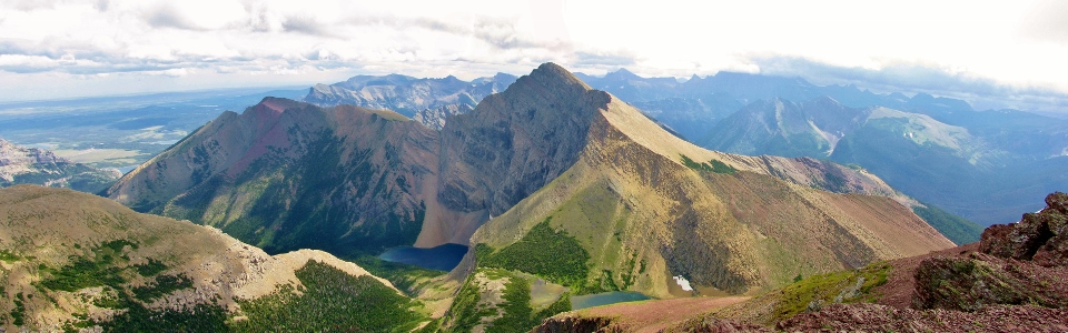
Carthew-Alderson panorama.
.jpg)
The kneeling pose may become a new 'go to' in the mountains.
.jpg)
Hoping that the wind isn't messing up my hair.
.jpg)
And to your right, you'll see beautiful Akamina Ridge in BC, site of hikes such as the one we did yesterday.
.jpg)
The crazy ones.
.jpg)
Waterton panorama: from peaks to prairies.
.jpg)
Mountains end.
.jpg)
Scoping out the route up Mount Alderson.
.jpg)
I'm in love with the colors in this area. Yellow and red rocks with blue tarns!
.jpg)
Carthew Lakes. You can make out the popular Carthew-Alderson trail around them. This trail, though lengthy, eventually brings you back to the Waterton townsite where our ride was parked.
.jpg)
Peaks on the other side of Waterton Lake.
.jpg)
Back down to the Carthew-Alderson col. Wind picking up...
.jpg)
She believes she can fly. But really, it's just the hurricane-force winds propping her up.
.jpg)
Carthew Lakes, or as Aurore called them...the Marmodrome. Why you ask?
.jpg)
Marmot!
.jpg)
You can actually see the wind gusts on the water to the right at this point...
.jpg)
Stubborn snow above the tarn.
.jpg)
Starting to get wet...
.jpg)
Complimentary colors in the rain.
.jpg)
Beautiful alpine forests and falls between the tarns.
.jpg)
Enjoying the fine weather!
.jpg)
Weather becoming less fine...
.jpg)
Epic marmot above the Marmodrome.
.jpg)
Waterfalls connecting the tarns.
.jpg)
Approaching the lowest of the Carthew Lakes.
.jpg)
The weather on the summit of Mount Carthew seems to have taken a turn for the worse since we came down!
.jpg)
Flowers!
.jpg)
Awesome waterfall between the Carthew Lakes and Alderson Lake.
.jpg)
Alderson Lake in the heavy rain/hail.
.jpg)
Alderson Lake at the base of Mount Alderson's impressive north wall.
.jpg)
Are we having fun yet? Only 7 more km to go!
.jpg)
A soggy Alderson Lake.
.jpg)
A soggy Matt at Alderson Lake. Wouldn't have really mattered if I fell in at this point; I was already drenched.
.jpg)
Further proof that she's crazy.
.jpg)
6.8 km later we emerged at Cameron Falls in the Waterton townsite, considerable wetter, and pants considerably dirtier than when we started...
.jpg)
Stop doing. Start thinking.