Mount Field and the Burgess Shale
Elevation: Mount Field – 2643 m, Walcott Quarry – 2286 m
Elevation Gain: Mount Field – 1168 m, Walcott Quarry – 811 m
Mount Field is the southern-most high point of Fossil Ridge which connects it to larger Mount Wapta to the north. Mount Field (and the town of Field, BC at its base) was named for Cyrus West Field, a Massachusetts entrepreneur who was involved in laying the first telegraph cable across the Atlantic Ocean. Field visited the present site of Field, BC as a guest of the Canadian Pacific Railway in 1884. Mount Field’s west-facing slopes are home to the world-famous Burgess shale and the associated Walcott Quarry where paleontologist Donald Walcott discovered an astonishing variety of fossils in 1909. The 505 million year-old fossils are unique in that they preserve delicate soft-tissue structures of the organisms from which they were formed offering a unique glimpse into the evolution of life on our planet.
My Ascents:
August 17 2008
On the occasion of my biology-loving best friend’s birthday, I arranged for him and I to take part in a tour of the Burgess shale in Yoho. Needing to meet our tour group in Field at 8:00am, we opted to drive out to Lake Louise the night prior and camp in the “scenic” overflow campground. Although the objective for the day was the Walcott Quarry, upon discovering that we did not have to hike with our tour group on their return trip, we opted to extend our day by scrambling up nearby Mount Field.
.jpg)
Temple Mountain in Lake Louise basks in the morning alpen glow.
.jpg)
The VW in the “scenic” Lake Louise overflow camping.
.jpg)
Crystal clear and calm Yoho Lake after quickly gaining elevation from the Takakkaw Falls trailhead.
.jpg)
Entering the forbidden zone! The Walcott quarry is a UNESCO world heritage site, and there is no public access (hence paying for a tour).
.jpg)
Emerald Glacier nestled atop the Vice President.
.jpg)
No-see-um Falls draining the Emerald Glacier and feeding Emerald Lake in the valley below.
.jpg)
Mounts Carnavon, The President, the Vice-President, and Michael Peak (from left to right) above Emerald Lake.
.jpg)
Looking through Yoho Pass to the Waputik Icefields and the Alberta border.
.jpg)
Scenic Emerald Lake.
.jpg)
Looking up towards Fossil Ridge and the Walcott Quarry from the Emerald Loop Trail. Only a few hundred meters separate the shales that exquisitely preserve the fossils of soft-bodied Cambrian organisms from metamorphic rocks in which the 505 million year old fossils would have been destroyed.
.jpg)
Looking back along the route traveled. Mount Wapta lies at the northern end of Fossil Ridge.
.jpg)
Distant Mount Vaux, the highest peak in the region.
.jpg)
Grant at the Walcott Quarry. Happy birthday!
.jpg)
The view from the quarry. Pity the “poor” souls who have to spend summers up here excavating.
.jpg)
Our guide for the day gives us the 'Fossil talk'. Mount Burgess in the background.
.jpg)
The first trilobite of the day! I accidentally sat on him during the fossil talk!
.jpg)
Trilobite posterior. Anterior MIA.
.jpg)
One of the larger trilobites I found; about the size of my wallet.
.jpg)
Trilobites in all directions.
.jpg)
Ottoia: A large carnivorous worm common in the Burgess Shales. Many of the fossils of this soft-bodied creature are so well preserved that the animal's musculature and digestive system can still be seen.
.jpg)
A close-up revealing the gut and musculature of an ottoia.
.jpg)
Our guide and her fiance who she dragged up for the day.
.jpg)
The claw of an anamalocaris, the dominant predator of the shales. For years, many of these claws were found and thought to be headless shrimp. Eventually the first complete anamalocaris was found, revealing the scope of the predator which was up to 3 feet long!
.jpg)
Vauxia: An extinct sponge.
.jpg)
The strange body plan of wiwaxia stirs up taxonoimical debate among experts.
.jpg)
The most common trilobite (and extinct class of arthropod) in the Burgess Shale; Olenoides.
.jpg)
Haplophrentis: A small shelled creature which had to 'arms' used for locomotion.
.jpg)
Leanchoilia was likely blind, feeling its way along the depths with long tentacles.
.jpg)
Members of our group sift for treasures in the shales below Fossil Ridge.
.jpg)
Ominous clouds over Mount Wapta. There's no danger associated with lightning at high elevations is there?
.jpg)
Extraordinarily well-preserved sponges, possibly vauxia.
.jpg)
Never has anyone looked so delighted to sift through rocks for hours! And once the sifting is done, it's time to ditch the tour group and scramble!
.jpg)
Table-sized rock along the scramble up Mount Field with dozens of well-preserved organisms.
.jpg)
A close-up of the table-sized fossil slab. Back end of a trilobite or leanchoilia?
.jpg)
Mount Stephen across the valley. Mount Stephen is also home to an impressive number of trilobites!
.jpg)
The route up Mount Field follows the southwest ridgeline. Fossils continue to litter the slope.
.jpg)
Catching his breath or hunting for trilobites on the way up? Fortunately, the two were not mutually exclusive!
.jpg)
The view from the summit. Mount Wapta and Fossil ridge on the left, the Waputik Icefield on the right. Takakkaw Falls (the starting point of our hike) visible in the distance.
.jpg)
Grant surveys Mount Stephen across the valley. An impressive plummet separates the two!
.jpg)
Summit cairn high above the cute town of Field.
.jpg)
Mount Burgess above Burgess Pass to the left of Emerald Lake...do the clouds look ominous to anyone else?
.jpg)
Mount Wapta and Takakkaw Falls. It may not look like it from this distance, but Takakkaw falls are the second highest falls in Canada.
.jpg)
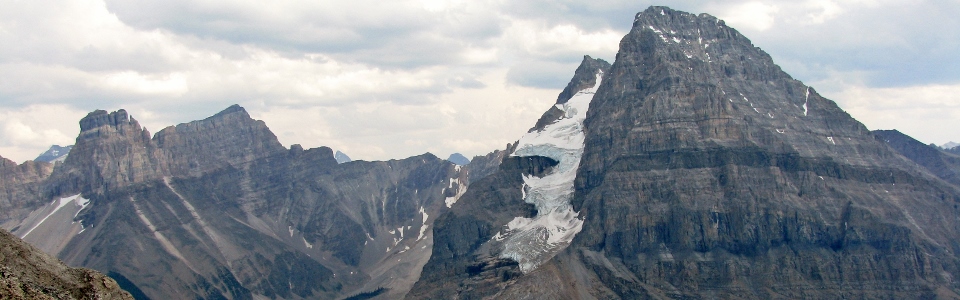
The Presidential range behind Mount Wapta.
.jpg)
Taking in the last of the summit sun as the dark clouds advance. Their ominous appearance prompted us to hasten our descent.
.jpg)
Looking back after down climbing the crux. Thunder begins to worry us.
.jpg)
This photo was taken ~5 minutes after the previous one. A lightning strike less than a mile from us sent us on a mad sprint down the scree to the safety of the trees in Burgess Pass! Land speed records were set.
.jpg)
Burgess Pass Panorama.
.jpg)
Getting back to Takakkaw Falls after a LONG walk (30 km or so).
.jpg)
The 'rooster comb' of Takakkaw Falls, where the falling water surges up and away from the cliff face. The height of the comb increases as the day goes on and the melt from the Daly Glacier increases. A lovely vantage from which to drink a beer at the end of a long day!