Mount Rae
Elevation: 3218 m
Elevation Gain: 1000 m
Mount Rae is the highest point in the Misty Range and the highest peak visible from nearby Calgary. Indeed, a small glacier on the north face of Mount Rae is the head of the main watershed to the city. Mount Rae is comprised of Mississipian rock which is over 325 million years old and contains an abundance of fossils, particularly horn corrals. The peak was officially named by John Palliser in 1859 to honor Dr. John Rae. Rae conducted several major expeditions in the Arctic and became the first European to survive an Arctic winter living solely off of the land. His most significant accomplishment was establishing the final leg of the Northwest Passage, the Rae Strait. A peak in Nunavut also honors Rae.
My Ascents:
August 9 2009
After returning from the Swiss Alps and my highest summit to date (Allalinhorn – 4027 m), I was antsy to get back at it in the Canadian Rockies. While growing up, I routinely hiked to Ptarmigan Cirque with my parents where they would lull away the afternoon napping in alpine meadows while I prospected for fossils. When I purchased my first copy of “Scrambles in the Canadian Rockies,” the route beyond Ptarmigan Cirque to the summit of Mount Rae immediately made its way onto my “to-do” list as a result of my fond childhood memories of the area and Rae’s lofty height. With peak scrambling season upon us, Gord, Aurore and I decided to take advantage of the warm mid-August weather to finally take on Rae!
.jpg)
Gord and I make our way through peaceful alpine meadows en route to Ptarmigan Cirque and, ultimately, Mount Rae.
.jpg)
The lush green meadows now well behind us, we followed a well-established trail towards the back of the cirque. The pointy peak in the background is actually a gendarme which obscures the view of Rae’s true summit beyond.
.jpg)
Enjoying a brief snack break at the back of Ptarmigan Cirque. From here, the route ascends the steep gullies above me to the obvious col.
.jpg)
Steep LOOSE terrain on the way up to the col. Given the popularity of this route (note the crowd below), this is an excellent place for a helmet.
.jpg)
Gord and Aurore opt for steeper slabs which provided more firm footing on the way up to the col.
.jpg)
Life amidst the desolate scree.
.jpg)
Former life amidst the desolate scree: horn corrals litter the slopes above Ptarmigan Cirque.
.jpg)
Aurore brushes off the dirt after a dusty ascent to the col.
.jpg)
Panorama of the Elbow Valley including the now diminutive Elbow Glacier and Tombstone Mountain from the col. Click to see larger.
.jpg)
Aurore checks out the poor pitiful remains on the glacier.
.jpg)
Practicing her tight rope-walking skills. These would certainly come in handy higher up as the ridge towards the summit narrowed.
.jpg)
Avoiding the gendarme (which was visible from Ptarmigan Cirque below) by following another well-travelled path below it on the climber’s left. The summit of Mount Rae finally comes into view above.
.jpg)
Lots of photography breaks as always.
.jpg)
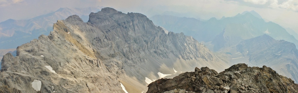
The reason that we stopped for so many photos! A spectacular panorama of the Misty Range through the summer haze. From left to right: an eastern outlier of Rae, Storm Mountain (mid-ground), Misty Mountain (background) and Mount Arethusa (foreground). Click to see larger.
.jpg)
The south ridge of Mount Rae continues to narrow en route to the summit. The exposure to the climber’s right is particularly significant, however, I felt that the exposure to the left was also worse than it looks in this photo.
.jpg)
Crawling along the narrowest crux section. Four points of contact are more stable than two, right?
.jpg)
Looking back at the crux section: some of the more intense “moderate” scrambling that I’ve completed.
.jpg)
Aurore pauses to contemplate the remainder of the route up.
.jpg)
Some of the exposed ridge top could be avoided by grinding up steep scree/slab to the climber’s left, however, I’m not sure that this felt any safer.
.jpg)
Gord completes a final dash to the relatively broad summit while I opt for a more cautious approach.
.jpg)
Mount Rae’s summit panorama is dominated by its spectacular eastern outlier. Mount Burns and the front ranges are beyond to the left while the rest of the Misty Range lies to the right. Unfortunately, haze somewhat spoiled the view. Click to see larger.
.jpg)
A small tarn at the end of a colossal glacier-carved cirque to the southeast.
.jpg)
The haze made for some good black and white photography. Pictured here (in order of increasing distance): Mount Arethusa, Storm Mountain and Mist Mountain.
.jpg)
Modelling her macho mittens on the summit.
.jpg)
Looking back to the col where we first gained Rae’s southwest ridge. Mounts Tyrwhitt (left) and Pocaterra (right) faintly visible despite the fact that they’re less than 5 km away.
.jpg)
Looking northwest towards the Opal Range: Mount Roberta on the left, Gap Mountain in the center and Elpoca Mountain on the right.
.jpg)
Elbow Lake, the headwaters of the Elbow River, nestled in at the foot of Mount Rae.
.jpg)
Steep terrain leading westward down to the Elbow Valley.
.jpg)
Gord and I enjoying the hazy afternoon; Mount Elpoca in the background. Despite the smile on my face, I was, at this point, fairly concerned about having to make my way back down the exposed and loose route to the col.
.jpg)
What goes up…
.jpg)
Catching my breath on descent. Any outcrop stable enough to lean upon was a welcome change of pace!
.jpg)
I might not have been having the time of life on Mount Rae but Aurore loved it. She even went out of her way to dick around on the gendarme on the way down.
.jpg)
Back to the security of the path below the gendarme.
.jpg)
Negotiating one last bit of narrow ridge before getting back to the col.
.jpg)
A stunning view of the tightly folded rock strata that make up adjacent Mount Arethusa from the col. Storm Mountain and Mist Mountain are almost as contorted in the background.
.jpg)
From the col, it’s still a long (LOOSE) way back down to Ptarmigan Cirque (path visible below). After a tense ascent and descent along the upper mountain, I was exhausted making this final descent more difficult than it ought to have been.
.jpg)
Back down in the cirque without any clue as to how I got this dirty.
.jpg)
Terra firma!
.jpg)
Washing up.
.jpg)
A beautiful alpine stream meanders through Ptarmigan Cirque. The large gendarme on the southeast ridge of Mount Rae visible beyond.
.jpg)
Alpine wildflowers on display below Mount Arethusa.
.jpg)
Indian Paintbrushes.
.jpg)
By the time we got back down to Ptarmigan Cirque, the skies seemed to have cleared somewhat. From here, it was a quick jaunt back to the trailhead after an exhausting afternoon.
.jpg)
Final views of Storm Mountain from the parking lot at Highwood Pass.
.jpg)
.jpg)
.jpg)