Mount Rundle
Elevation: 2949 m
Elevation gain: 1570 m
Mount Rundle is one of the most recognizable peaks in the Canadian Rockies and has probably graced more postcards and calendars than any other summit in the area. Towering directly over Banff, Rundle is particularly beautiful when viewed from several kilometers to the west near Vermillion Lakes. The massive mountain is actually a small mountain range which stretches 12 km in length between Banff and Canmore and features 7 distinct high points, of which the third from the west is the true summit. Despite its prominence, the ascent of the true summit involves difficult climbing and is rarely visited. Much more popular is the scramble route up to the second high point (which is only marginally lower than the third). Reverend Robert Rundle was a missionary who spent time with the Cree and Assiniboine aboriginals in the Banff area from 1840 to 1848 during which time he learned the local language and became heavily involved in their culture. Impressed by his work with these people, John Palliser named the peak in honor of Rundle in 1858. 30 years later, J. J. McArthur made the first ascent of the mountain; in the years since, a great many have followed in his footsteps.
My Ascents:
July 13 2008
Towering above Banff, Mount Rundle is one of the most photographed peaks in the Canadian Rockies. Somewhat surprisingly, the ascent of this massive peak is non-technical. Having recently taken up scrambling, these factors combined to entice me to attempt the Banff behemoth. Little did I know that I would be forced to attempt this postcard peak 3 times before finally enjoying the satisfaction of standing atop its summit!
Attempt 1 - August 31 2007
.jpg)
After hiking along a well-established but viewless trail for what felt like an eternity, I finally arrived at the central gully, above which the lower northern summit can be seen. From here the route crosses the gully to gain a steep, treed (at first) ridge called the Dragon’s Back.
.jpg)
Looking down the central gully towards Sulfur Mountain.
.jpg)
Shortly after breaking the tree line, I found myself quickly retreating as an afternoon thunderstorm moved in quickly from the west.
.jpg)
The view from my makeshift rain shelter back at the tree line.
.jpg)
Waiting out the first thunder storm under a tangle of trees.
.jpg)
Once the storm passed, I decided to continue back upwards. Above the tree line, the views of the extensive Rundle massif to the south provided inspiration to persist up the steep scree and slab of the Dragon’s Back.
.jpg)
Looking back down the Dragon's back towards Sulfur Mountain, another thunder-storm brewing in the distance...
.jpg)
Views of Banff from the Dragon's Back.
.jpg)
The true summit still a ways above. This was as high as I got before being chased down by thunder-storm #2.
.jpg)
Storm's a brewin'...
.jpg)
Defeated, I decided to call it a day and head back down rather than ascend the summit amidst the flurry of thunder-storms.
Attempt 2 - November 12 2007
.jpg)
After a thunderstorm-related defeat back in August, I decided to come back to Rundle in November for some more punishment. As you can see in this photo, taken upon arriving at the central gully, this trip would be marred by weather of a different kind.
.jpg)
Making my way past the windswept tree line and having a great deal of difficulty with my footing. Actually, it was worse in the trees where the harsh wind had yet to strip the slope of its snow cover.
.jpg)
Of our group of 4, 2 (including this fellow) made it to the summit. I, unfortunately, was not amongst those who succeeded.
.jpg)
The increasingly inhospitable trek up the Dragon's Back.
.jpg)
Time to turn around! With the blizzard closing in and my footing uncertain, I put an end to my and Roland's attempt. Don't let the smile fool you. I was both disappointed at the premature end to the excursion and petrified of the sheer rock faces to both my left and right.
.jpg)
A narrow section of the Dragon's Back requires some hands (and bum)-on manoeuvring. Roland claims that this technique is not found in any of the mountaineering manuals, but I stand by its effectiveness!
.jpg)
My nerve-wracking final jaunt across the narrow section of the Dragon's Back. A jaunt which Roland will tell you did not happen nearly as quickly as this picture would suggest...
.jpg)
The blizzard overtakes the true summit, obscuring it. Those who successfully summited this day were not rewarded with a view. Unless you count 'white' as a view. Which I do not.
.jpg)
The long walk to safety (and Guinness at the Rose & Crown)!
Attempt 3 - July 13 2008
.jpg)
Mount Rundle as seen from the Trans-Canada highway: FINALLY a nice day for an attempt! Of course, as Murphy’s law would dictate, this would be the day that I forgot to make sure that there was a memory card in my camera…fortunately, I had the pathetic 10 MB card that came with the camera in the case so I was able to capture a few summit photos from my only successful attempt on Rundle!
.jpg)
Mount Rundle seen from Banff.
.jpg)
From the summit: Mount Assiniboine towers above the rest of the southern Canadian Rockies.
.jpg)
Glaciated Mount Ball in Kootenay National Park to the west.
.jpg)
Cascade Mountain across the Bow valley from Mount Rundle
.jpg)
Lake Minnewanka through a window near the summit of Mount Rundle.
.jpg)
Holding the camera over the vertigo-inducing cliff on the north face of Mount Rundle, looking 1600 m straight down towards the Trans-Canada highway.
.jpg)
Sulfur mountain in the foreground; followed by wave upon wave of peaks to the west.
.jpg)
Grant’s awkward looking summit pose. To be fair it was bloody cold.
.jpg)
Trying not to fall off the 1600 m sheer cliff behind me. It made for a good picture and I lived to tell...
.jpg)
Looking across the Bow Valley towards Mounts Inglismaldie, Girouard and Peechee.
.jpg)
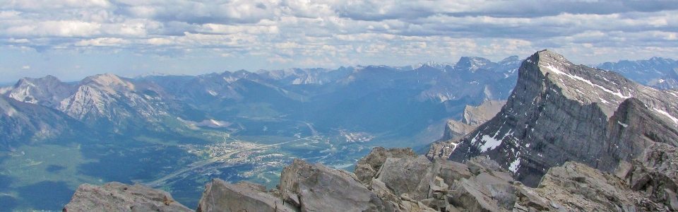
Canmore at the opposite end of the long Mount Rundle massif.
.jpg)
Looking along the Mount Rundle summit ridge towards the lower northern Rundle summit. Norquay ski area across the valley.
.jpg)
A final view of Bow Falls after safely descending to the trailhead. After 3 attempts (and 1 summit thank God), I won't be back on Mount Rundle again any time soon! Good riddance!