Mount Tyrwhitt
Elevation: 2874 m
Elevation Gain: 650 m
Situated on the Alberta/British Columbia border above Highwood Pass, Mount Tyrwhitt was named for Admiral Sir Reginald Y. Tyrwhitt in 1918. The Admiral commanded destroyer flotillas during WWI and later rose to the rank of Admiral of the Fleet (the highest rank available in the British Navy). In addition to being named after an impressive individual, the peak’s first ascent involved another notable person: Conrad Kain guided Horace “Rusty” Westmorland and Alan Campbell up the peak in 1914. Conrad Kain was among the most well-respected guides of his time, claiming over 50 first ascents, the most notable of which was Mount Robson (the highest peak in the Canadian Rockies).
My Ascents:
August 9 2008
After sleeping in, Gord and I decided that we’d still like to head to the mountains and try to bag a peak. With a late start (and perhaps a mild hangover), we zeroed in on the peaks of the Highwood Pass area as they tend to involve quick ascents due to their relatively high starting elevation (2206 m). With an elevation gain of only 650 m required to ascend Mount Tyrwhitt, we quickly agreed upon its selection as our target for the day.
.jpg)
The view of the objective, Mount Tyrwhitt from scenic Pocaterra cirque. Note the rock arch at the midway point along the ridge.
.jpg)
Posing at Grizzly Col; The summit push ahead...
.jpg)
The ascent route from the col.
.jpg)
The view of Elbow Pass through the scenic rock arch on Mount Tyrwhitt.
.jpg)
Gord in front of the arch; Highway 40 through the window.
.jpg)
After spending a fair bit of time exploring and taking photos around the rock arch, it was time to resume the grind upwards.
.jpg)
Gord scrambling along the LOOSE ridge to the summit.
.jpg)
Summit view of Mount Pocaterra from Mount Tyrwhitt. The two mountains are connected by a long, and reasonably exposed ridge. Gentle and grassy Pocaterra Ridge can be seen on the right.
.jpg)
Ptarmigan Cirque bookended by Mounts Rae and Arethusa across the valley.
.jpg)
Elpoca and Tombstone Mountains beyond Pocaterra Ridge.
.jpg)
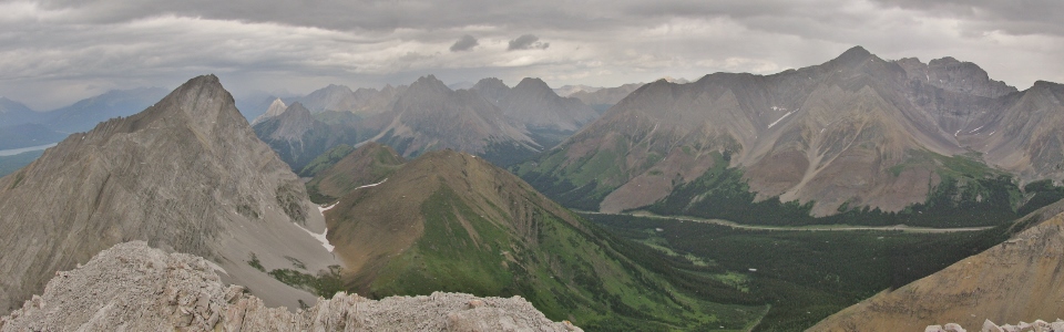
Highwood Pass panorama. Click to see larger.
.jpg)
The old man and the summit cairn.
.jpg)
Another summit bagged!
.jpg)
Nasty weather above massive glaciers to the west. We were stuck in a blizzard a few moments later (August 9). Careful examination of some of the other summit photos reveals falling snow.
.jpg)
Looking south along the Elk Range.
.jpg)
Upper and Lower Kananaskis Lakes.
.jpg)
Interesting weather around the Kananaskis Lakes.
.jpg)
Mount Indefatigable above Lower Kananaskis Lake.
.jpg)
Green flanks of Mount Sarrail above Upper Kananaskis Lake.
.jpg)
Looking west to Elk Lakes and Mount Joffre in the snow.
.jpg)
A striking glacier to the west.
.jpg)
Beautiful peaks to the SW.
.jpg)
Looking east beyond Mist Mountain (left) towards the prairies.
.jpg)
Recording our ascent in the register. '3 hours up. Summit view partially obscured by heavy falling snow'.
.jpg)
Storm Mountain and Mist Mountain beyond the much smaller Grizzly Ridge and Highwood Ridge.
.jpg)
Highwood Pass panorama. From left to right: Mount Rae, Mount Arethusa, Storm Mountain and Mist Mountain. Click to see larger.
.jpg)
Steep, loose, dangerous scree on descent. Every step down risked dislodging (what felt like) the entire mountain side.
.jpg)
Down climbing steeper terrain on descent.
.jpg)
Back down to Grizzly Col safe and sound.
.jpg)
Pocaterra cirque panorama. Click to see larger.
.jpg)
Looking back towards Mount Tyrwhitt and its characteristic rock arch.
.jpg)
Stunning wildflowers in the alpine environs of Pocaterra Cirque.
.jpg)
More flowers.
.jpg)
Looking toward Highwood Pass (and our car!) from a small pond. Snow has turned to rain at this elevation.
.jpg)
Grizzly diggings…Yo Bear!
.jpg)
Making haste (and a lot of noise) as we pass fresh grizzly diggings.
.jpg)
Goodbye Mount Tywhitt!
.jpg)
.jpg)
.jpg)