Sheol Mountain
Elevation: 2780 m
Elevation Gain: 1060 m
Sheol Mountain is an easterly extension of the ridge which descends from the summit of nearby Haddo Peak. The name “Sheol” is a reference to the Hebrew underworld of the dead. The peak was named by Samuel E. S. Allen in 1894 as a result of the gloomy appearance of the valley at its northern foot. In contrast, “Paradise Valley” lies to the south of the peak. Sheol Mountain was first ascended in 1903 by the Topographical Survey.
My Ascents:
August 8 2010
After seeing the impressive north face of Sheol Mountain from the summit of adjacent Fairview Mountain many, many times, Gord, Aurore and I decided that it was time to venture 1 peak to the south to check out the surrounding from there. The 6 km approach through Paradise Valley, however, became significantly longer on this day when it became apparent that no one in our group had bothered to read the signs on the well-marked Paradise Valley hiking trail. Despite these “route finding” issues, we were able to find our way up Sheol Mountain via a somewhat circuitous (and back and forth) route. For anyone planning to ascend this peak, I would highly recommend reading the trail signs and sparing yourself the extra laps down in the valley!
.jpg)
Early views of the objective: Sheol Mountain with Paradise Creek in the foreground.
.jpg)
Apparently we're only good at route finding on steep dangerous terrain. Not signed hiking trails. If we'd bothered to read this sign, we wouldn't have hiked an extra couple kms in the wrong direction (left)...
.jpg)
Occasional views of Temple's impressive north face break the monotony of the forest.
.jpg)
Wasatch Mountain up the Paradise Creek valley.
.jpg)
Paradise Porcupine!
.jpg)
Beautiful Lake Annette at the base massive Mount Temple. Only problem is we were supposed to start ascending Sheol about a km before we got to the lake (before crossing to the south side of Paradise Creek)...lost on well-marked hiking trails yet again...
.jpg)
Enjoying the lake since we bothered (unnecessarily) to hike all the way to it!
.jpg)
After retracing our steps and crossing back to the north side of Paradise Creek, we were finally back on the proper route! Sheol’s ascent route is via the gully on the right.
.jpg)
Lake Annette back on the other side of the valley (where it belongs). Aurore and Gord make their way up steep slopes while being attacked relentlessly by mosquitoes.
.jpg)
Stopping to enjoy the views of Paradise Valley on ascent.
.jpg)
Interesting scrambling in the right-hand gully.
.jpg)
Helmets may have been a wise choice at this point…it was around this time that the, previously pleasant, weather began to take a turn for the wet.
.jpg)
The final annoying scree slopes before the ridge crest; broken up by the occasional wet, slippery rock band. Interestingly, 'Sheol' is a Hebrew word for hell, but as Kane points out, the mountain itself isn't THAT bad.
.jpg)
On top of the ridge crest: views towards Lake Louise. Once atop the ridge crest, the summit of Sheol is a short distance east of the ascent gully.
.jpg)
Aurore down climbing along the ridge crest: the crux.
.jpg)
Down climbing the crux in the rain.
.jpg)
Gord lingering for photos on the undulating ridge crest of Sheol.
.jpg)
Looking back along the ridge. Weather improving?...
.jpg)
Graceful technique.
.jpg)
Despite the questionable technique, Aurore did make it to the summit!
.jpg)
Aurore and her preciousss (Ibuprofen) on the summit...
.jpg)
Temple!
.jpg)
Gord arriving on the summit with a reasonably scenic view of Temple and Lake Annette behind.
.jpg)
Looking north beyond Fairview Mountain to Mounts Whyte, Niblock and St. Piran.
.jpg)
Mount Daly and the Waputik Icefield to the north.
.jpg)
The peaks of Paradise Valley.
.jpg)
Pinnacle Mountain (left), Eiffel Peak (center) and Wasatch Mountain (right) across the valley. Sentinel Pass lies to the left of Pinnacle.
.jpg)
The switch-backing trail from Saddle Pass to Paradise Valley 1000 or so meters down.
.jpg)
Mounts Whyte (left) and Niblock (right) on the other side of Lake Louise.
.jpg)
Summit Gord!
.jpg)
Twenty second summit of the year!
.jpg)
The always-popular summit register, but alas: no pen or pencil with which to write in it! Fail.
.jpg)
Lacking the tools with which to write in the register, Aurore and I left muddy fingerprints as proof we were there...mine's the dirtier of the two.
.jpg)
The old man and I on top!
.jpg)
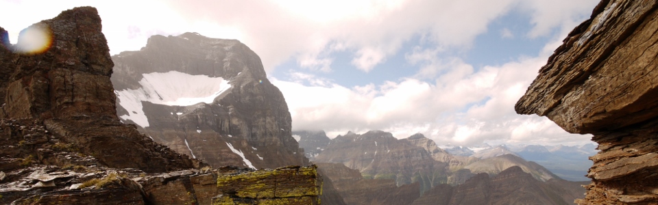
Paradise Valley panorama. From left to right: Mount Temple, Pinnacle Mountain, Eiffel Peak, Wasatch Mountain and Mount Hungabee. Click to see larger.
.jpg)
Panorama to the Lake Louise side. Left to right: Mount Victoria, Mount Whyte, Mount Niblock, Mount St. Piran, Fairview Mountain and a distant Mount Hector. Click to see larger.
.jpg)
Mount Hector beyond the summit of Fairview Mountain. Although I didn’t hate Sheol as much as some of those with me (Aurore), I must admit that Fairview Mountain offers a substancially better view for SUBSTANTIALLY less effort!
.jpg)
Looking back down to the Lake Louise townsite through Saddle Pass.
.jpg)
She gets really intense when the chocolate comes out at the summit...
.jpg)
Cloud begin to roll back in over adjoining Haddo Peak: probably a good cue to start our descent.
.jpg)
Aurore making her way back up the crux on the ridge crest.
.jpg)
About to head down. Last high altitude views of Mount Hungabee and the Horseshoe Glacier at its base.
.jpg)
The way down...
.jpg)
Unusual descent technique.
.jpg)
God that valley is still a LONG ways down…
.jpg)
While wildflowers on the lower slopes were pretty, we were all pretty sick of Paradise Valley by the time this longer-than-it-needed-to-be scramble came to an end!
.jpg)
.jpg)