The Tower
Elevation: 3117 m
Elevation gain: 1350 m
Hans Gmoser's climbing party named "the Tower" following their successful first ascent in 1957, however, photos from their ascent appear to suggest that they may have actually climbed The Fortress (some 3.5 km away). It seems likely that a case of mistaken identity is to blame for the unusual name of this peak, which does not bear any particular resemblance to a tower.
My Ascents:
October 23 2010
The Tower is one of those peaks that looks SO cool, SO impossibly steep in Kane’s Outings guide that I’ve wanted to attempt it ever since laying eyes upon it. When I set out from Calgary solo on this late October morning, I had no intent of climbing the Tower; I figured that by this time of year, it would be snow-covered and unreasonable. My original objective was to be something more docile along the Spray Lakes corridor. As I drove down the Smith-Dorrien highway and the sun rose, however, it started to become apparent that there was very little snow at elevation…perhaps the Tower could still be climbed, I though. Only 1 way to find out…
.jpg)
Early views of wildlife...very early actually, on the side of the highway.
.jpg)
After an uninspiring plod to Rummel Lake, I finally saw my objective, the Tower, for the first time of the day.
.jpg)
Mount Galatea across Rummel Lake.
.jpg)
Interesting rock formations along the Galatea summit ridge above.
.jpg)
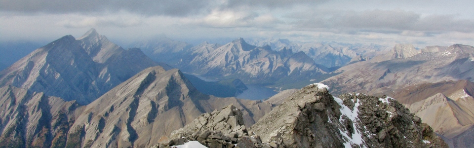
Approaching Rummel Pass: the Tower dominates the view.
.jpg)
Rummel Pass: from left to right: Commonwealth Peak, the always impressive Mount Birdwood, the Fist (foreground), and in the background Mount Smuts.
.jpg)
Commonwealth Peak and the significantly larger Mount Birdwood across the Spray Valley.
.jpg)
Where the second Rummel Lake was supposed to be.
.jpg)
Very late season hiking. Very late season scrambling in about 5 minutes.
.jpg)
On the other side of Rummel Pass.
.jpg)
The intimidating north face of Mount Galatea (the highest peak in the Kananaskis Range) on ascent. The Fortress in the distance. Note the angle of the slabs in the foreground. Turns out that the Tower doesn’t just look steep.
.jpg)
The Fortress.
.jpg)
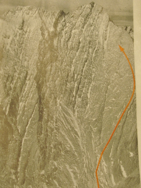
The summit of the Tower: guarded by multiple rock bands. One of the most challenging scrambles I'd attempted to date, particularly solo and late season!
.jpg)
The Opal Range on the eastern side of Highway 40 (Kananaskis Trail).
.jpg)
About ready to quit: I just crawled across an exposed ridge, only to be confronted with some serious climbing in order to gain access to the summit block. Additionally, the weather started taking a turn for the worse. Time to head down...maybe?
.jpg)
Rather than retracing my steps across the exposed ridge crest, I started to descend an obvious gully in which I found this spectacular fossil. As a I descended, however, I spotted a break in the rock band above that looked reasonable. Hoping that the weather would hold, the ascent was back on!
.jpg)
Another interesting find above the rock band! An Alberta 75th anniversary pin (from 1980) sitting out atop a rock! This pin is older than I am; proof that this peak is not a popular objective.
.jpg)
Summit success! 3117 m high on a late October afternoon solo. Not bad!
.jpg)
Looking north from the summit: Mount Engadine and Mount Buller in front of Spray Lake. Mount Nestor and Old Goat Mountain on the far side of the lake.
.jpg)
Galatea Lakes: about 800 vertical meters below.
.jpg)
Kananaskis Country front ranges to the east.
.jpg)
Big peaks near the continental divide. From left to right: the Fortress, Mount James Walker, Mount Galatea, and Mount Chester.
.jpg)
More poor weather approaching from the west.
.jpg)
The Wedge and Opal Ridge.
.jpg)
36th summit of the year...and solo! Possibly the most difficult yet...
.jpg)
K-Country self-portrait. I like the frost on my toque.
.jpg)
A very frozen Rummel Lake looking a long ways away (vertically and horizontally).
.jpg)
The slabby-to one side, exposed-to the other ridge that scared the hell out of me an ascent.
.jpg)
Close-up of the popular Galatea Lakes hike far below.
.jpg)
Mount Sparrowhawk, Mount Lougheed and pointy Wind Mountain to the north.
.jpg)
Galatea and the Fortress dwarf the K-Country front ranges.
.jpg)
Looking out over K-Country. Also praying that I get down safely on my own.
.jpg)
A clearing to the west grants temporary view of glaciers clinging to the continental divide. The highest peak: Mount Sir Douglas in both the clouds, and in BC.
.jpg)
Light getting low as the late October afternoon drags on. Perhaps it might be best to start descending?
.jpg)
Looking back up following an intriguing down climb...
.jpg)
Rather than retrace my steps and have to face the exposed ridge crest again, I opted to continue down the gully that I’d started to use for descent earlier. At this first good opportunity, I would cross to the skier’s left to regain (hopefully) my ascent route. This narrow ledge looked like the best opportunity to me…
.jpg)
Success! Thrilled to find the cairn I built on the way up (since I could find none already existing)! There's nothing like the knowledge that you're still on a route that can get you to the bottom...
.jpg)
Light getting seriously low and still WAY too high = SHIT.
.jpg)
Looking back up at the Tower’s ascent route after a mad scramble (pun intended) to get back to the hiking trail before it got pitch black! Damn that mountain is steep. It was at this time that I realized that the hasty descent had shredded the <arse end of my pants and that my wallet was no longer in my possession – pick pocketed by the Tower, it was too dark to go back up to look for it so I continued down. Thank God it wasn’t my car keys that were lost!
.jpg)
Terra firma! Well worth the dirty kiss! About 20 minutes later, the light completely subsided and I was forced to hike down through dense woods in the pitch black (Yo Bear!). Thank God for the flashlight in the survival kit Jenn bought me for Christmas! Lessons learned: always carry a headlamp from now on and don’t bring your entire wallet with you!