Following yet another week of rain in Calgary and, therefore, snow in the mountains immediately west, I once again set my peak-bagging sights to the south. It’s not that I’m totally opposed to peak-bagging in the snow, it’s just that I’m sick of it! Winter is long enough in this part of the world. There’s no need to extend it! Generally when I suggest a day trip to Waterton, potential scramble partners balk at the “long drive.” After a thoroughly enjoyable day on Ruby Ridge last week, however, Gord had no problems joining me for another long drive south. He even brought along my mom for good measure this time!
Thanks to a bit of a massive hangover (Friday night was fun - from what I remember), we got a bit of a late start and, as a result, had to select an objective on the smaller side of the scale. According to Nugara, Bellevue Hill “makes a great trip when time and energy are lacking,” so we set our sights on this peak despite its unimpressive official name. I must note, that while this peak is on the smaller side of things for a “mountain”, it is positively massive for a “hill” and I also have to admit feeling a little bit of trepidation when we set out to get my mom up her first “Nugara scramble”!
.jpg)
The usual traffic on the Red Rock Parkway. Our objective for the day can actually be seen just to the left of the sheep.
.jpg)
With my mom joining us, we opted to forego Nugara’s moderate ascent route in favor of Bellevue Hill’s easier south-facing slopes (the usual Nugara descent route). We parked at a signed “Native History” lookout about 5 km down the Red Rock Parkway. Our route from here ascends the (mostly)open grassy slopes in the center of the photo as they gradually narrowed to a ridge. The easy ridge crest brings you to the false summit (also in the center of the photo) which is about 5 minutes away from the true summit (out of sight).
.jpg)
The “open” slopes were quite fertile and were covered with white flowers that will soon be Saskatoon berries. Even without having read Bob Spirko’s trip report, we would have suspected that this slope was prime bear territory. We, therefore, made a LOT of noise and, unlike Bob, we encountered no bruins.
.jpg)
A beautiful wildflower display with Waterton’s highest peak, Mount Blakiston, in the distance up the valley.
.jpg)
As if the geology in Waterton isn’t colorful enough, our ascent slopes were absolutely littered with wildflowers.
.jpg)
The slopes were also littered with these ravenous and disgusting little caterpillars, which we tried to avoid whenever possible. As it would turn out, these weren’t the insects that we should have been concerned about…
.jpg)
The grassy slopes beginning to narrow to a ridge just above Gord. The ridge undulates somewhat, preventing you from seeing your route too far in advance, however, travel up it is, at all times, easy if not a little steep in places.
.jpg)
The “hounds” enjoying their hike.
.jpg)
A brief breather on ascent. No one complained about having to stop and enjoy these views of Ruby Ridge and Mount Blakiston across the valley!
.jpg)
Getting into Waterton’s characteristically colorful rock. Upper Waterton Lake comes into view to the east.
.jpg)
Beautiful contrast between the red of the rocks and the fresh green in the valleys below.
.jpg)
Mount Cleveland, the tallest peak in Montana’s Glacier National Park, dominates the view to the southeast.
.jpg)
Resistance training for Crux!
.jpg)
Crux scouts out the route from the false summit to the red rock-covered true summit ahead. From the false summit, the true summit is only minutes away and only marginally higher.
.jpg)
The old folks make their way towards the true summit with an improving panorama, dominated by Vimy Peak (center foreground) and Mount Cleveland (right) on the far side of Upper Waterton Lake, unfolding behind them.
.jpg)
Success! My mom on the summit of her first Nugara scramble with Crux and I!
.jpg)
The colorful and intimidating looking summit block of Mount Galwey with Anderson Peak further beyond and an outlier of Blakiston on the left.
.jpg)
Mount Galwey (allegedly a scramble as well) and its imposing summit.
.jpg)
Mom enjoys the colorful Waterton panorama. From left to right: Ruby Ridge, Mount Lineham (distant), Mount Blakiston, Mount Galwey and an outlier of Mount Dungarvan. Click to see larger.
.jpg)
Gord enjoys the view of the flat lands in the opposite direction.
.jpg)
An outlier of Mount Dungarvan and tiny Lakeview Peak to the north.
.jpg)
The Shell Waterton plant in the distance.
.jpg)
The prairies and the mountains meet rather abruptly here.
.jpg)
Wind turbines dot the prairies below.
.jpg)
Proof that there are bison in the Waterton bison paddock. I’ve driven through numerous times and never seen them but today was able to spot them from high above!
.jpg)
Crux enjoys the cool summit breeze.
.jpg)
Looking south up the Akamina Parkway. Mount Crandell on the left and Ruby Ridge on the right directly across the valley.
.jpg)
Ruby Ridge (left foreground), Mount Lineham (background) and Mount Blakiston.
.jpg)
The car parked at the signed lookout far below.
.jpg)
Montana’s Kintla and Kinnerly Peaks tower over Canada’s snowy Forum Peak (left) and Akamina Ridge (right).
.jpg)
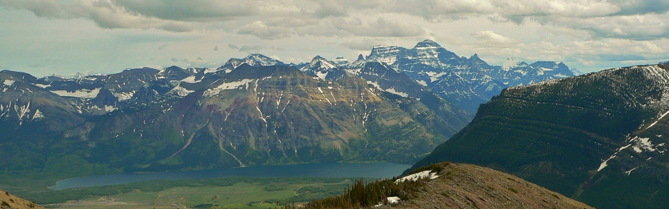
Upper Waterton Lake panorama. From left to right: Sofa Mountain, Vimy Peak and massive Mount Cleveland. Click to see larger.
.jpg)
Kaiser Point is a spectacular outlier of Mount Cleveland.
.jpg)
Waterton Lake well below the Bellevue Hill summit cairn.
.jpg)
Family photo on top before starting the trip back down.
.jpg)
Crux doing his best dinosaur impression on a snow patch.
.jpg)
Improved views of Anderson Peak (right) and Lost Mountain (left) up the Red Rock Parkway on descent.
.jpg)
One last photo-op at the false summit.
.jpg)
Gord provides some assistance on the way down. Such a gentleman!
.jpg)
On the way down, we managed to dodge the steepest section of grass slopes thanks to these lovely scree slopes. There was, however, a caveat…
.jpg)
The caveat: the scree funnelled us into this miserably dense brush. Fortunately, we did not have to thrash through it for too long before we emerged on the road about 100 m away from our car and, as we would later find out, covered in ticks. Not sure how my mom and Gord made out but I had the pleasure of picking three of the little bloodsuckers out with tweezers later that night when I got home.
.jpg)
Of course, Crux managed to find a bone to chew on and, incomprehensibly, did not appear to suffer any tick bites.
.jpg)
Interesting skies over Mount Crowsnest on the long drive back home.
.jpg)
.jpg)