With a Stampeders game to watch at 7:00pm, I decided to set my sights on Kananaskis in search of a Saturday scramble that might have Chris, Crux and I home in time for kickoff. After scanning the Outings guides for suitable puppy (and Chris)-friendly options, I settled on the north summit of Kent Ridge as our target. While I was a little apprehensive for fear of trail washouts following June’s floods, Bob Spirko’s recent trip report convinced me that we would easily be able to navigate our way up Kent Ridge. As it turned out, navigation through the labyrinth of logging road approach trails wasn’t as easy as I thought it would be (but this had nothing to do with any flood damage).
.jpg)
After failing to see a moose on the Spray Lakes/Smith Dorrien highway with Brianne yesterday, Chris and I spotted this handsome animal around the first bend in the road. Every time that Brianne and I take this highway anywhere, I warn her to keep her eyes peeled for moose and without fail, we see none. The second I drive this stretch of road without her, we’re practically tripping over them! On one occasion last year (without Brianne of course), I spotted 7 moose during 1 trip!
.jpg)
From the parking lot, there is a large newly-graded road behind the out-houses, however, the maze-like trail system actually starts at this black metal gate located slightly uphill of the bathrooms and to the north. Immediately past the gate, we set off on the trail to the left (north) which runs perpendicular and away from the flood damage shown here. This minor damage was the only flood damage that we encountered the whole trip.
.jpg)
Our second wildlife sighting of the young day. Crux was especially keen to see this little fellow.
.jpg)
After travelling for about 20 minutes along the trail, we encountered this unusually tall sign (no, Chris isn’t THAT short) at a junction. Unfortunately, the color-coded trail system that Nugara describes in his guide is no longer in use so we were left to our own devices to attempt to navigate the approach maze. We took the (climber’s) right branch at this junction since the other direction appeared to be heading towards James-Walker Creek.
.jpg)
We only walked along this new path for about 5 minutes before getting the sense that it was starting to take us back down the mountain. Not wanting to lose elevation, we simply found an area where the forest appeared to be less dense and started thrashing our way up the hill on what may have been an old cut line. The open area quickly closed in, however, and before we knew it we were suckered into full-on bushwhacking.
.jpg)
As we thrashed through the thick forest, we eventually found a steep rocky drainage which we followed up hill in the hopes that it would spare us from some of the nasty brush…
.jpg)
...as you can see, it didn't!
.jpg)
Although there were a couple sections (see previous photo) where the drainage was clogged with nasty deadfall, the majority of the way up was relatively open and provided some interesting hands-on (or in this case paws-on) scrambling on steep slabs.
.jpg)
Chris learning his ascent technique from Crux.
.jpg)
After slogging up the steep drainage, we eventually came to open forested slopes which eventually gave way to open scree slopes. The scree was unpleasant but the improving view of Mount Murray and Cegnfs across the valley gave us an excuse to pause frequently.
.jpg)
Once on the scree, we worked our way gradually to the ridge on the climber’s right where we actually found a trail! From the ridge crest, we could finally see our target ahead and well above.
.jpg)
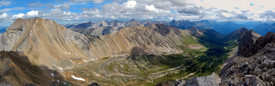
As we neared the summit of the outlier, the panorama across the valley really started to open up. From left to right: Mount Black Prince, Mount Jellicoe, Mount Smith Dorrien, Mount French, Mount Murray, Cegnfs, Mount Burstall and Mount Birdwood. Click to see larger.
.jpg)
Crux and I make our way to the summit of the outlier. Unfortunately, the summit is still about 400 m above us at this point (and we have to lose 75 m of elevation to get down to the col in between the outlier and the summit).
.jpg)
Although it is possible to descend the small rock bands that divide the outlier and the col below, we opted for the more puppy-friendly grass slopes on the south side before side-hilling towards the col. These slopes were every bit as steep as they look in this photo.
.jpg)
Despite our side-hilling efforts, we still ended up descending a couple of small rock bands to get to the col. Fortunately, these were well within Crux’s (and Chris’) abilities.
.jpg)
Crux at the col.
.jpg)
As we made our way up the foreshortened grass/scree slopes to the summit from the col (now far below in this photo), the weather started to take a serious turn for the worse. Despite the wet conditions and lack of view, we pressed on planning to weather a storm below the summit if necessary.
.jpg)
The Spray Range faintly visible through the spray, mist and rain. At this point, it was starting to look as though the day would become a write-off.
.jpg)
A faint glimmer of hope as we neared the summit: the cloud breaking slightly to the south.
.jpg)
Could it be?! Almost at the summit and the clouds are definitely lifting...
.jpg)
Summit sunshine! We must have had horseshoes up our backsides because the sun came out and the clouds (for the most part) lifted moments before I arrived on the summit!
.jpg)
We were only the third ascent party of the year. As you can see, we were in good company!
.jpg)
A colorful summit panorama to the east including (from left to right): Mount Chester (in the clouds still), Mount James Walker, red rocked Mount Inflexible, Mount Lawson (far right) and the Opal Range beyond. Click to see larger.
.jpg)
Mount James Walker.
.jpg)
A small pocket glacier clinging to life at the base of a steep cirque on James Walker.
.jpg)
Looking through the James Walker – Inflexible col towards (shaded) Mount Kidd and the prairies to the east.
.jpg)
Crux wondering what happened to Chris?
.jpg)
Here he comes! Better late than never! ;)
.jpg)
Adding his name to the register. Nice work! As you can guess by his attire, it was far from warm at the summit on this day.
.jpg)
An absolutely spectacular view of the Spray Range and the lush green valley below to the west. Click to see larger.
.jpg)
A closer look – from left to right: Mount Murray, Cegnfs, Whistling Rock Ridge (background), Mount Leval, Mount Vavasour, Snow Peak, pointy Mount Birdwood, Pig’s Tail, Commonwealth Peak, Mount Smuts, Mount Assiniboine (distant and in the clouds as per usual), the Fist, Mount Shark and Tent Ridge. Click to see larger.
.jpg)
Closer still: scenic Snow Peak nestled between Mounts Burstall and Birdwood.
.jpg)
Massive Mounts Eon, Aye and Assiniboine beyond Mount Smuts.
.jpg)
Nothing beats a day in the mountains with your best friend!
.jpg)
Looking south along the length of Kent Ridge towards the Kananaskis Lakes the “summit” of Mount Kent some 300 or so meters below us. How does that work?
.jpg)
The gorgeous green valley tucked in between Kent Ridge and Mounts Inflexible and Lawson. Click to see larger.
.jpg)
I never did get to see this valley from the summit of Mount Lawson. Fortunately my weather luck was better on this day!
.jpg)
Mounts Denny and Potts beyond Opal Ridge with Fisher Peak higher still in the distance. The connecting ridge between Inflexible and Lawson looking anything but "straight forward" in the foreground.
.jpg)
A beautiful little tarn (one of several) in the valley below.
.jpg)
Looking south towards Highwood Pass and the still-closed stretch of Kananaskis Trail. Mount Rae remains in the clouds beyond Elpoca Mountain and smaller Gap Mountain. Storm Mountain, Mist Mountain, diminutive Mount Lipsett (really, that’s a mountain?) and Mount Pocaterra all visible amidst the clearing sky.
.jpg)
Mount Chester finally emerges from the clouds to the north calling for one last summit panorama including Spray Lake (left), Mount Galatea (the highest peak in the Kananaskis Range), Mount James Walker, Mount Kidd (distant) and Mount Inflexible. Click to see larger.
.jpg)
One last summit shot with Crux before heading back down to try to catch kickoff!
.jpg)
Back at the col looking south towards Mount Sarrail and Mount Joffre (still in the clouds) beyond Mount Warspite.
.jpg)
Rather than going back up the outlier and returning the way that we came, we opted to take the optional descent down the drainage to the north of the col leading to James Walker Creek. The views above the tree line remained awesome. Click to see larger.
.jpg)
A colorful wildflower display in the drainage.
.jpg)
Once we entered the forest, the scrambling in the gully became more and more interesting! Occasionally, we ran into cliffs but these were always easy to overcome by escaping either to the right or to the left into the forest briefly before returning to the rocky gully.
.jpg)
Crux leads the way down the drainage. As it turned out, the ascent and descent drainages ended up providing the most enjoyable scrambling of the day. As an added bonus, the north-facing descent drainage was cool and mossy making for a pleasant and easy-on-the-knees way down.
.jpg)
Near the bottom of the drainage, an unmistakable cut line marks you key to exit the gully. This cut line leads quickly to the James Walker Creek trail which returns you to the Sawmill parking lot after an easy 30 minutes of hiking.
Epilogue: we made it back in time for the Stamps game but it might have been better if we hadn't - sigh.
.jpg)
.jpg)
.jpg)
.jpg)
.jpg)
.jpg)
.jpg)