With most of the highways through Kananaskis finally back open following the horrific floods in June, I decided to venture away from the National Parks for the first time in over a month. I hadn’t visited Burstall Pass since I was a child so I decided to target Snow Peak which is ascended from the top of this popular, and incredibly scenic, hike. Not wanting to repeat the mistake of being LATE for dinner, Crux and I left Calgary at 6:15am to take on our objective. I originally thought that we would be joined by a friend, who shall remain nameless (*cough Chris*) until 6:00am when he texted to inform me that he was suffering from “heat stroke” acquired while sitting outside at the Stampeders game the night prior. Funny, I was in the seat in front of him, yet I felt fine…he also mentioned only getting 4 hours of sleep, which seemed inconsistent with the actions of a man who suffered “heat stroke” during a football game which took place at 5:00pm the night prior. Perhaps “heat stroke” is the new “hungover”? ;) Regardless, poor Chris missed one hell of a scramble. Snow Peak is simply magnificent and after this trip, has quickly jumped onto my top 10 favorites list!
.jpg)
Beautiful views of Pig’s Tail (left) and Commonwealth Peak (right) from the gravel flats on the Burstall Pass trail. Fortunately, the trail was not damaged during June’s flooding, however as before, the little creeks that cross these gravel flats require some creative route-finding to get around. Failing that, Chuck Norris-style leaps (Brianne’s mom knows what I’m talking about) should do the trick! Regardless of creek-crossing style, I’m happy to report that I managed to not wet my boots winding through this labyrinth of streams!
.jpg)
Great views of Piggy Plus (left), Mount Robertson (center), the Robertson Glacier and Mount Sir Douglas from the gravel flats.
.jpg)
8 km in and up at Burstall Pass, 11,000er Mount Sir Douglas is spectacularly revealed to the south.
.jpg)
Mount Assiniboine looks surprisingly close from Burstall Pass!
.jpg)
Crux enjoying the views in all directions from the pass. He also enjoyed his second breakfast of the day here!
.jpg)
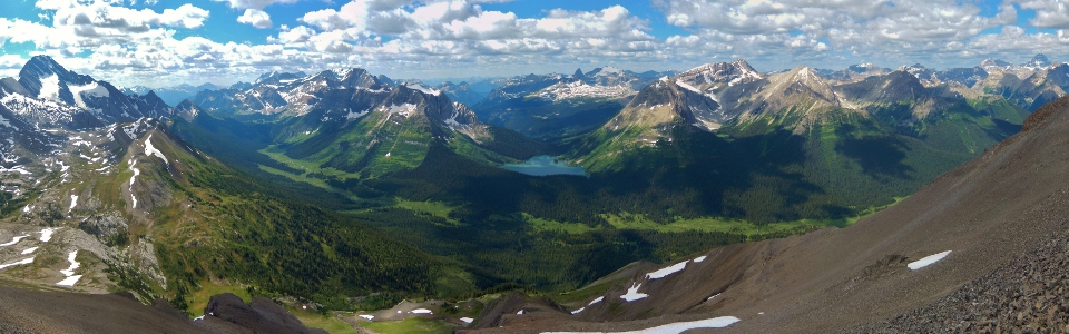
Burstall Pass panorama. From left to right: a distant Mount Assiniboine, Snow Peak, beautiful Mount Birdwood, Pig’s Tail, Commonwealth Peak, Mount Galatea (distant), Gusty Peak (distant) and the Fortress (distant). Click to see larger.
.jpg)
The objective: Snow Peak as seen from Burstall Pass. The route up is quite simple, following the right-hand ridge line closely all the way to the summit. All though it looks like a reasonable undertaking, I was on the summit less than an hour after this photo was taken.
.jpg)
A cairn mirrors the form of Mount Birdwood just beyond Burstall Pass.
.jpg)
Mount Burstall (center) appears beyond wildflower-covered ascent slopes.
.jpg)
Looking back to Burstall Pass and the spectacularly lush valley west of it on ascent. I found myself stopping frequently for photos despite the fact that the climb was not arduous.
.jpg)
Grass eventually gives way to scree as Crux gains elevation. The scree is the nasty treadmill sort but fortunately, there’s not a lot of it and it makes for a pleasant descent.
.jpg)
Looking back down beyond Mount Birdwood to the braided creeks crossing the Burstall Pass gravel flats and draining into the Burstall Lakes in the valley below.
.jpg)
Moss campion adds color to the otherwise barren upper scree slopes of Snow Peak.
.jpg)
A snow patch high up on the peak was the only real obstacle of the day with a potential cornice on the right and a steep run-out ending in cliffs on the left (out of the photo). I was glad to have my ice-axe along while crossing this slope.
.jpg)
Near the summit, Mount Assiniboine is revealed through the gap between Snow Peak and its cornice.
.jpg)
A beautiful view of Mount Birdwood – one of the Rocky’s most famous dogtooth mountains – from the summit.
.jpg)
From the summit, you’re granted a spectacular panorama of the lush valley to the west. This view instantly places Snow Peak on my top 10 list! Click to see larger.
.jpg)
A sea of peaks including the Royal Group on the left surround colorful Mount Leman (left of the lake) and Leman Lake across the valley.
.jpg)
A distant Mount King George dominates the view to the south.
.jpg)
Belgium Lake tucked in at the base of the Royal Group to the south.
.jpg)
A beautiful creek winds its way through the valley.
.jpg)
Telephoto of Mount King George.
.jpg)
Telephoto of Mount Queen Mary.
.jpg)
Crux wearing Mount Smuts like a hat.
.jpg)
Mount Smuts (left) and Birdwood (right) look formidable from all sides.
.jpg)
An excellent view of the ascent route up Mount Smuts (widely considered to be the most difficult ascent in Kane’s book). Beyond Smuts, the peaks of Kananaskis’ Spray Valley including Old Goat Mountain, Mount Nestor, the Fist and Mount Lougheed can be seen.
.jpg)
The fun ascent route of the Fist.
.jpg)
Peaks I and II of distant Mount Lougheed dwarf the smaller summit of Mount Buller. Canmore lies on the other side of the Lougheeds.
.jpg)
On top of my third peak of the weekend!
.jpg)
Leman Lake looks beautiful from Snow Peak.
.jpg)
Aptly named Shark Fin Peak and Mount Soderholm are the real eye catchers beyond Leman Lake.
.jpg)
Telephoto of Shark Fin Peak. Hopefully Calgary City Council’s ban doesn’t include summits!
.jpg)
Crux checking out the view of Assiniboine.
.jpg)
Eon Mountain, Aye Mountain and Assiniboine.
.jpg)
Great views of the highest peak in the southern Canadian Rockies.
.jpg)
Beyond Assiniboine, I could see as far as Mount Ball which towers over Kootenay National Park. Numa Mountain, climbed 2 days earlier, is just on the other side of Ball.
.jpg)
Telephoto of glaciated Mount Ball.
.jpg)
The panorama in the other direction (towards Burstall Pass) is pretty nice too…click to see larger.
.jpg)
The Chester Lake valley.
.jpg)
The Fortress and its surprisingly easy ascent slopes.
.jpg)
Mount Chester - a personal favorite!
.jpg)
Mount Burstall.
.jpg)
Cegnfs and Mount Murray.
.jpg)
The British Military Group, highlighted by Mount Sir Douglas across Burstall Pass.
.jpg)
Mount Sir Douglas is a real eye catcher.
.jpg)
Looking down, down, down to the beautiful green meadows of Burstall Pass.
.jpg)
Just as Crux and I were getting ready to leave the summit, a group of 13 Rocky Mountain Ramblers showed up. I was shocked to see a group that large after thinking that I was going to have this peak all to myself. In fact I was so convinced that I would have the peak to myself, that I had been singing at the top of my lungs moments earlier (track listing included “Bad Bad Leroy Brown” and “More Than a Feeling” for some reason). For once, I actually had someone around to take a summit photo of Crux and I! I only hope that they didn’t mind my singing voice! ;)
.jpg)
As I descended, the rest of the Ramblers made their way up. I was very surprised to see an experienced group crossing this snow without ice-axes (not 1 of the 13 of them had one). As you can see, the run out from an uncontrolled glissade here would be unpleasant. In their defense, by the time they arrived, the snow had softened somewhat but still…
.jpg)
The treadmill scree that was a pain on ascent proved to be very fun on descent; except for poor Crux who got half buried in the deep loose rock!
.jpg)
One last beautiful view of Burstall Pass before running back down the 8 km hike and, for once, getting home in time for supper! On my way down, I was surprised to run into a former chemistry professor of mine at the University of Calgary, Tom Back. TGB (as we called him) was hiking up Burstall Pass with his wife and we caught up briefly before I resumed my jog down. What was really strange was that earlier in the day, while signing the register on the summit, a page fell out. When I picked that page up to replace it, I noticed that Tom Back had signed that particular page back in 2008. With the exception of the number of chemists (myself included) who climb this peak, however, I still have to say that it is a personal favorite!
.jpg)
.jpg)
.jpg)