After reading some amazing Canada day long weekend trip reports from other Icefields Parkway scrambles on Clubtread.com, I was excited that the main ranges appeared to have rounded into perfect scrambling form. Mount Andromache has been on my “to-do” list for years. I even considered bagging this peak as a two’fer from Little Hector several years ago (a notion I quickly dismissed when I realized how tired I was on top of Little Hector) but, for one reason or another, I had never gotten around to it. Fortunately, there’s no time like the present! After a hard day of unpacking in our new home, Brianne and Crux (he was especially helpful with the unpacking) were also ready for a day in the mountains. We even convinced Mike to actually join us for a scramble up Andromache (proof that he’s not ALL talk). ;)
.jpg)
The intimidating highway-side view of Mount Andromache’s west face.
.jpg)
Crux, Brianne and Mike working their way up the well-defined trail on the south side of Hector Creek.
.jpg)
Crux shows Brianne the best way to cross the creek a short time later.
.jpg)
Approaching the waterfalls above Hector Creek. As you can see, the terrain steepens pretty dramatically here. The scrambling is actually enjoyable on good ledges but there are 2 – 3 spots that weren’t exactly “puppy friendly”. Crux made it up without any assistance, however, later in the day, Mike and I had to lift him down a couple of spots.
.jpg)
Family photo on one of the larger ledges.
.jpg)
Above the waterfalls Mike works his way along the base of a rock band into the open basin below Hector Pass (Little Hector is straight ahead of him).
.jpg)
The sheer south walls of Andromache tower above the open basin below Hector Pass. You can make out the open scree slopes that we used for ascent in the distance on the far right. These scree slopes are exactly as far away as they look!
.jpg)
The Breezy Goat doing what it does best: climbing something random.
.jpg)
Great views of Mount Balfour (left) and Bow Peak (right) back down the open basin.
.jpg)
Brianne and Mike groveling up the steep scree slopes above Hector Pass. Mount Hector (left) and Little Hector (right) provide a stunning backdrop to the otherwise uninspiring plod. The scree on this slope and, indeed, on most of this peak was generally nasty.
.jpg)
The view of the Hector Glacier is as awesome as the scree is unpleasant!
.jpg)
An impressive icefall on the Hector Glacier.
.jpg)
Crux enjoys a snowy respite from the sharp scree on a large plateau just below the eastern “unnamed peak” of Andromache. 11,000er Mount Wilingdon makes an appearance behind him.
.jpg)
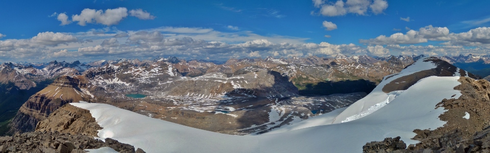
An impressive panorama from the plateau. Click to see larger.
.jpg)
Snowy Cataract Peak and pointy Molar Mountain augment the view to the east.
.jpg)
Looking ahead to the snowy “unnamed peak” above the plateau.
.jpg)
Mike and Brianne kick step up the steep snow slope.
.jpg)
Looks like they’re having fun!
.jpg)
The true summit finally comes into view from the top of the “unnamed peak”. Unfortunately, you have to lose about 100 m of elevation and then regain it to get there.
.jpg)
100 m lower than the last photo and gearing up for the final ascent. We stayed on the snow for most of the ascent but were very careful to stay well to the climber’s left for fear of a possible cornice on the right.
.jpg)
Mike hits the jets as the summit is finally within striking distance.
.jpg)
Kicking the final steps up!
.jpg)
A spectacular view of Bow Lake bracketed by Bow Peak (left) and the Dolomites (right) from the summit. The fledgling Bow River winds its way down the valley far below.
.jpg)
Brianne and I on top.
.jpg)
Mike’s turn for the “hero” pose.
.jpg)
A sea of peaks to the northwest above Bow Lake. Some notables (from left to right): Crowfoot Mountain, Mount Thompson, Mount Jimmy Simpson, Cauldron Peak, Mount Forbes (distant), Mount Patterson, Howse Peak, White Pyramid and Mount Chephren.
.jpg)
Massive Mount Forbes (left) and the many peaks of Mount Lyell (right) above the distant Lyell Icefield.
.jpg)
Crux basking in the summit sun.
.jpg)
Icefields panorama featuring Hector Lake (left) and Bow Lake (right). Click to see larger.
.jpg)
Mount Balfour above Hector Lake. On its flanks, Turquoise Lake drains into Margaret Lake which drains into Hector Lake.
.jpg)
The steep icefall on the north face of Balfour.
.jpg)
A small tarn at the base of Noseeum Peak; the Dolomites (left), Watermelon Peak (center) and Mount Willingdon (right) in the distance.
.jpg)
Some notable Icefields Parkway peaks to the north. From left to right: White Pyramid, Mount Chephren, Mount Amery (distant), Cirque Peak (midground), Observation Peak (background), the Dolomites (foreground) and Mount Murchison.
.jpg)
Panorama to the south including Mount Hector (left), the peaks of the Louise group (center) and Mount Balfour over Hector Lake (right). Click to see larger.
.jpg)
Mike counting 11,000ers.
.jpg)
Skoki peaks beyond the Hector Icefall: the Wall of Jericho (center), Ptarmigan Peak (right), Pika Peak (righter) and Mount Richardson (far right).
.jpg)
Telephoto of Mount Hector’s Snoopy-shaped summit block.
.jpg)
Telephoto of the Lake Louise group to the south. From left to right: Mount Temple, Mount Fairview, Haddo Peak, Mount Aberdeen, Mount St. Piran, Deltaform Mountain, Neptuak Mountain, Mount Niblock, Mount Lefroy, Mount Hungabee and Mount Victoria.
.jpg)
A really cool angle of the Louise giants Lefroy, Hungabee and Victoria.
.jpg)
Sun illuminating the glacier on Cathedral Mountain (right) while the massive Goodsirs are in the shade (left).
.jpg)
Mounts Bident, Quadra, Babel and Temple dwarf Saddle Mountain and Mount Fairview.
.jpg)
Panorama of the more remote peaks to the north beyond the Andromache Glacier. The “unnamed peak” which we ascended earlier is visible on the far right as is a collapsed cornice which we were able to stay well away from. Click to see larger.
.jpg)
Massive chunks of snow from the collapsed cornice.
.jpg)
More views into Skoki. From left to right: Mount Douglas, Mount St. Bride, Oyster Peak, Skoki Mountain and Fossil Mountain – site of one particularly good memory! ;)
.jpg)
Brianne and her peak-bagging baby.
.jpg)
One last couple summit shot before beginning the long journey back down.
.jpg)
Back on the “unnamed peak” looking at our tracks to and from the true summit.
.jpg)
Ice axes out for the steep descent of the upper slopes of “unnamed”.
.jpg)
Glissade time! Once we passed through some rocks which were poking through the steepest upper part of the snow slope, we let loose!
.jpg)
Crux, Mike and Brianne in various stages of an exhilarating glissade down “unnamed”.
.jpg)
Evening sun as we hike back out the open basin below Hector Pass.
.jpg)
After some creativity, we got Crux back down the ledges near the waterfalls. From this point on, it’s an easy walk out!
.jpg)
Rainbow in the waterfall.
.jpg)
Andromache turned out to be a little long for our poor peak-bagging puppy so we bought him a treat at Wendy’s to make it up to him. ;)
.jpg)
.jpg)
.jpg)
.jpg)