After injuring my knee the week prior during an epic on Mount Ball, I was somewhat reluctant to commit to a scramble for the September long weekend. Following a week’s rest, however, the knee continued to feel better and, with perfect weather forecast, I decided to seek an objective whose ascent would involve stunning scenery but no steep and uneven terrain. After ascending Mount Bourgeau with ease several years earlier, it immediately came to mind as a possibility (although some might debate the wisdom of testing out my knee on a 24 km, 1500 vertical meter outing). When my mom told me that Gord wanted to climb Bourgeau (without me so much as having mentioned it to them in years), I decided that a father-son ascent was in order. Although Grant had just hiked up Bourgeau last year, he agreed to join us since he had fond memories of the excellent view (and had, apparently, forgotten about the long and tedious approach hike to Bourgeau Lake)!
.jpg)
After nearly 2 hours of hiking at a good pace through unremarkable woods on the Bourgeau Lake trail, we finally cleared the tree line and were treated to views of beautiful alpine meadows tucked between Mount Bourgeau and Mount Brett (pictured here). Note that this trip report does not feature any photos taken from the approach hike because:
a) There’s not much to take photos of until the lake 7.4 km in.
b) I’d prefer to forget about the dull hike to the lake and focus on remembering the stunning scenery above it!
.jpg)
After hiking up the valley in the shade all morning, the sun finally (and dramatically) rose above Mount Bourgeau as we reached Bourgeau Lake.
.jpg)
Bourgeau Lake itself is quite pretty, however, it would be hard to justify walking through 7.4 km of forest without a view if this was your final destination. Fortunately from here on, the views are nothing short of outstanding!
.jpg)
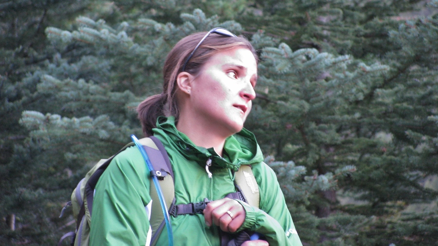
Gord enjoys the views from the very well-established trail which quickly gains elevation beyond the lake.
.jpg)
Above Bourgeau Lake, the trail passes 3 distinct alpine tarns – the first of which is pictured here.
.jpg)
The tarns may, indeed, be prettier than Bourgeau Lake! Looking back to the first tarn from above, Mount Bourgeau’s gray dome-shaped summit is revealed for the first time atop cliffs which plummet almost 800 vertical meters to Bourgeau Lake (out of sight) in the valley below.
.jpg)
The third and final tarn at Harvey Pass is, perhaps, the most scenic of the bunch, overlooking Sunshine Meadows and massive Mount Assiniboine.
.jpg)
Looking back: this tarn is beautiful from both directions! The blue waters of the third tarn make for a beautiful contrast with the reddish rock on Mount Brett.
.jpg)
Harvey Pass panorama. Mount Bourgeau’s gentle ascent slopes (left) rise above Eagle Mountain (known to most as Goat’s Eye Mountain), Mount Howard-Douglas (known to most as Lookout Mountain), Wawa Ridge, Quartz Hill and the Monarch (right). In the distance, Mount Assiniboine pierces the sky. Click to see larger.
.jpg)
The impressive north face of the Monarch – most frequently seen covered in snow from the Sunshine Village ski resort.
.jpg)
Grant makes his way up the rocky but gentle upper slopes of Bourgeau as the vapor trail from a jet disperses in the crystal clear sky above.
.jpg)
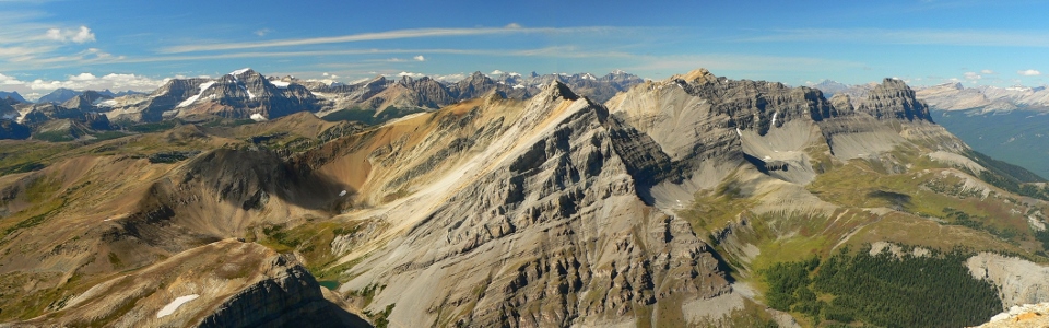
Above the third tarn at Harvey Pass (bottom right), the massive peaks of the continental divide to the west are beautifully revealed. Click to see larger.
.jpg)
The most impressive peak visible immediately west is massive Mount Ball and its many glaciers. After standing on the summit of this peak only a week ago, I was eager to see it from a different perspective this week!
.jpg)
The panorama towards Mount Brett, Pilot Mountain, Massive Mountain (misnomer) and the Bow Valley is equally impressive as we near Bourgeau’s cliff-top summit (right). Click to see larger.
.jpg)
Gord enjoying a breath-taking view as he reaches the 2930 m tall summit of Mount Bourgeau.
.jpg)
A stubborn cornice clings to the east face of Bourgeau. Bourgeau is a long, but never technical, ascent. On a clear day like this, you can spend hours picking out peaks in all directions.
.jpg)
Mount Assiniboine towers above all other peaks in the southern Canadian Rockies including (from right to left): Eon Mountain, Mount Magog, Terrapin Mountain and the Towers. The massive and remote Royal Group can also be seen in the distance on the left.
.jpg)
Telephoto of the distant Royal Group – Mount King George is the highest peak.
.jpg)
Grant is dwarfed by the scenery as he explores the broad summit.
.jpg)
The peaks of the British Military Group are also visible in the distance to the south. A pocket glacier clings to the base of Beersheba Peak’s north face on the left.
.jpg)
Distant 11,000 foot giants Mount Sir Douglas (left) and Mount Joffre (right).
.jpg)
Crux and I pose for a summit photo with the Sundance Range and a myriad of recognizable Kananaskis peaks beyond.
.jpg)
The jagged western face of the Sundance Range (high point: Sundance Peak) with Kanananakis Country beyond.
.jpg)
Pointy Old Goat Mountain (center) and Mount Nestor (right) beyond the Sundance Range.
.jpg)
Mounts Lougheed (left) and Sparrowhawk (right) beyond the Sundance Range.
.jpg)
The characteristic shape of the Three Sisters (again beyond the Sundance Range).
.jpg)
An ocean of peaks from the summit. Banff on the left and Assiniboine on the right with Kananaskis and the Sundance Range in between. Click to see larger.
.jpg)
Looking east down the Bow Valley to Banff.
.jpg)
Mounts Inglismaldie, Girouard and Peechee tower above diminutive Tunnel Mountain and the town of Banff.
.jpg)
The many peaks of Mount Rundle visible beyond the obvious fire road up Sulphur Mountain.
.jpg)
Mounts Edith and Norquay below the much larger Cascade Mountain.
.jpg)
Summit panorama of the Sawback Range (left) and Banff (right). Click to see larger.
.jpg)
Mount Ishbel (center) and the rest of the Sawback Range behind tiny Massive Mountain.
.jpg)
Even the man-made eyesore on the summit of Bourgeau can’t spoil a view this impressive!
.jpg)
Mount Brett and Pilot Mountain of the Massive Range stretch out towards the Bow Valley. The continental divide (highlighted by Mount Ball on the left) towers above Harvey Pass (bottom right) to the west. Click to see larger.
.jpg)
The formidable summit block of Pilot Mountain with Mount Hector in the distance.
.jpg)
Beyond Mount Brett (foreground) and Storm Mountain (left) the massive peaks of the Lake Louise area flirt with the sky. Glaciated Mounts Lefroy and Temple visible in the distance on the right. Click to see larger.
.jpg)
Telephoto of Mount Lefroy.
.jpg)
Beautiful Mount Ball with smaller Beatrice Peak and Stanley Peak visible to the right. The twin summits of massive Mount Goodsir are visible above Beatrice and in the distance.
.jpg)
Looking down at the first of the tarns above Bourgeau Lake. The excellent trail is easily spotted from above.
.jpg)
Panorama with Bourgeau Lake far below. Click to see larger.
.jpg)
Bourgeau Lake.
.jpg)
Crux enjoys the view with the peaks of Kootenay National Park beyond (his ear is touching Foster Peak).
.jpg)
The air was so clear that we could see the Howser Spires in the distant Purcells.
.jpg)
More views of the very distant Bugaboos.
.jpg)
Crux and I on top!
.jpg)
The weather and the views were so good that Grant and I were happy to let photographer Gord do his thing on the summit for almost 2 hours!
.jpg)
He did, however, put down the camera for long enough to have his summit photo taken.
.jpg)
Great views of Assiniboine through the crisp clear air.
.jpg)
Group summit shot.
.jpg)
After 2 hours, it was time to start the long hike back to the car heading down the gentle upper slopes of Bourgeau to Harvey Pass before retracing our steps back to the lake and the interminable forest below it.
.jpg)
Stunning late afternoon light back down at Harvey Pass.
.jpg)
Crux cooling off in the highest of the tarns on the return trip.
.jpg)
Crux shaking off and cooling off Grant in the process! ;)
.jpg)
Last stunning views of Assiniboine beyond the tarn at Harvey Pass before heading down.
.jpg)
Last views of Bourgeau rising up majestically beyond a tarn before the LONG walk out. Despite the long walk out (which may leave you feeling like this), Bourgeau is one of the prettiest peaks I’ve climbed. On a clear day, the views are beyond compare!
.jpg)
.jpg)
.jpg)
.jpg)
.jpg)
.jpg)
.jpg)
.jpg)