Lipalian Mountain
Elevation: 2710 m
Elevation Gain: 1028 m
Lipalian is a geological term which refers to the unconformity between Precambrian and Cambrian rock formations. The peak was officially named by William C. Gussow in 1958, however, it is likely that it was ascended much earlier in 1859 by James Hector and again in 1884 by Arthur Coleman. Although Coleman referred to it as a “commonplace mountain,” he was quite correct to note that provided a scenic “introduction to its stately neighbors.” Although early ascents of the peak required travel through much brush, today one is spared a bushy approach by the “Larch” area of the Lake Louise ski resort.
My Ascents:
June 20 2014
Trailhead: Fish Creek (Skoki Lodge) Trailhead
GPS Track: Lipalian Mountain
Some people are envious that I have every second Friday off work. I, myself, admit that it’s a sweet deal but it pales in comparison to my most loyal hiking partner’s situation. I am, of course, referring to Crux the dog who has every Friday off. How does the saying go? Oh right: “it’s a dog’s life.”
On this particular Friday in a dog’s life, it just so happened that neither Crux nor I had to be at work so we decided to make our way out to Lake Louise for a scramble. Although I’m usually hesitant to hike in Lake Louise before July, I figured that the open west-facing ascent slopes of the Lake Louise Larch ski area might be reasonably snow-free, allowing access to Lipalian Mountain. Although there was still a reasonable amount of snow left, it proved generally avoidable on ascent and granted some entertaining glissades on descent.
.jpg)
As with most ascents across the valley from Lake Louise, this one starts with a numbing plod up the Temple fire road. The walk up the rugged road is dull, but the view of stately Mount Temple is second to none!
.jpg)
In a little less than an hour, the road brought us to the “Larch” chairlift (with scenic Mount Redoubt beyond).
.jpg)
Just passed the chairlift, we ascended the open ski run immediately to the north. The Lake Louise ski resort is prime grizzly territory so Crux and I were sure to make lots of noise while ascending these open alpine slopes!
.jpg)
Route-finding is usually harder than this!
.jpg)
Near the top of the ski run, the target (still over 400 m above) comes into view. Although summer ascents often require some boulder-hopping, Crux and I easily escaped this nastiness by sticking to the more gently angled snow slopes.
.jpg)
Alright! Some “paws-on” scrambling! This beats work anyday!
.jpg)
Beautiful views of Mount Richardson (left), Pika Peak (center) and Ptarmigan Peak (right) beyond the ski resort.
.jpg)
Mounts Douglas (left) and St. Bride (right) make their first (and only sunny) appearance of the day.
.jpg)
Massive Mount Temple dominates the view across the Bow Valley.
.jpg)
Post-holing or boulder-hopping? Take your pick!
.jpg)
Unique needle-like scree above the snow.
.jpg)
At the top of the scree/snow slope, you reach a false summit. The true summit (left) lies a pleasant 10 minutes away.
.jpg)
While hiking along the broad ridge to the true summit, scenic Kootenay peaks like Storm Mountain highlight the view to the south.
.jpg)
The customary summit selfie. The view from Lipalian is truly outstanding! To the west: the Louise peaks of the Great Divide; to the east: a sea of Skoki area peaks.
.jpg)
Skoki panorama. From left to right: Mount Richardson (now in the clouds), Pika Peak, Ptarmigan Peak, Mount Redoubt, Fossil Mountain, Heather Ridge, Unity Peak (foreground), Mount Douglas (background), Oyster Peak, Mount St. Bride (background) and Purple Mound. Click to see larger.
.jpg)
Mount St. Bride.
.jpg)
Mount Douglas.
.jpg)
Mount Redoubt (left), Fossil Mountain (center) and Heather Ridge (right).
.jpg)
A snowy Mount Richardson.
.jpg)
Crux enjoying a seat in the summit snow.
.jpg)
The long Protection Mountain massif (including Bulwark Peak, Armor Peak and TV Peak) stretches out down the Bow Valley.
.jpg)
Looking farther down the Bow Valley towards Pilot Mountain.
.jpg)
Crux enjoys his lunch as the clouds descend over the continental divide and Lake Louise.
.jpg)
The “view” of the continental divide. Unfortunately by the time that I reached the summit, clouds had obscured the Louise area giants. Still beats the view from my window-less office though…
.jpg)
Rained off of my second summit in a row! Beating a hasty retreat back down to the ski area below.
.jpg)
Of course, once I had descended 300 vertical meters, the skies cleared; just once I would like to climb a peak in overcast conditions only to have the clouds clear when I reach the summit!
.jpg)
A plume of cloud streaks off of Mount Temple’s north-facing glacier.
.jpg)
Moraine Lake nestled in below the Valley of the Ten Peaks.
.jpg)
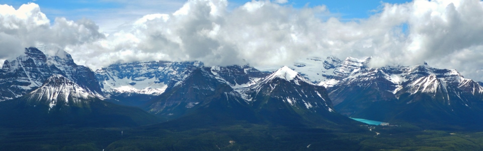
Lake Louise panorama (now that the clouds decided to lift). From left to right: several of the Ten Peaks, Mount Temple, Mount Hungabee (still in the clouds), Mount Aberdeen, Fairview Mountain, Mount Victoria, Collier Peak, Pope’s Peak, Mount Whyte, Mount Niblock, Mount St. Piran and Mount Bosworth. Click to see larger.
.jpg)
The crown jewel of the Canadian Rockies: Lake Louise.
.jpg)
Lake Louise and the Chateau.
.jpg)
Peaks of the Waputik Icefield including Mounts Niles (center) and Daly make an appearance through the clouds.
.jpg)
After stopping to photograph the previously invisible peaks, Crux and I resumed our descent enjoying a long (somewhat icy) glissade down a ski run. Unfortunately it was tough to get much speed going on this blue run; I may have to keep my eyes out for black diamond next time!
.jpg)
Brief views of Mount Victoria serve to distract from the dull deproach on the dreaded Temple fire road.
All in all, I think that Crux and I can chalk this up as another productive Friday! A guy could get used to this "dog's life" thing!
.jpg)
.jpg)