Midnight Peak
Elevation: 2340 m
Elevation Gain: 950 m
Midnight Peak is the unofficial name of the double-peaked mountain immediately to the south of Baldy Pass. The peak was named following an incident in which a group of Rocky Mountain Ramblers attempted to descend via an alternate route. Their choice left them stranded atop cliffs and although they ultimately made it down safely, they did not reach their cars until midnight.
My Ascents:
March 7 2014
Trailhead: Baldy Pass Trailhead
GPS Track: Midnight Peak
FINALLY! After weeks of minus 40 degree temperatures, warm Chinook winds were forecast to bring pleasant temperatures back to Calgary, and more importantly, the Rockies! Following a wind slab-thwarted attempt on Midnight Peak earlier this winter, Crux and I decided to head back to Kananaskis on my Friday off to finish what we started. During our earlier failed attempt, we encountered wind-loaded 35 degree slopes which stopped us in our tracks above Baldy Pass. This time, I decided to avoid Baldy Pass all-together, opting for a bushier route via the west ridge. While this approach would mean leaving the trail and bushwhacking for most of the day, I hoped that the gentler angle of the west ridge would avoid all serious avalanche terrain. We arrived at the Baldy Pass trailhead shortly after sunrise and were surprised to see how much snow had fallen in this, normally dry, region of the front ranges. Suffice to say, (stolen borrowed) snowshoes were going to be required.
.jpg)
Crux makes his way through fresh snow on the Baldy Pass trail. Our intended route ascends the steep forested hill in the background before moving to the left along Midnight Peak’s west ridge.
.jpg)
A fresh layer of snow covered most of this summer’s flood damage. A faint “squiggle” in the ground is the only evidence of the 5 foot deep fissure below the surface. Mind your step!
.jpg)
After leaving the trail, a steep bushwhack up forested slopes ensued. Following a brutal hour of suffering without a view, the trees began to thin, revealing a snowy Wasootch Peak to the south.
.jpg)
The panorama improves as the forest thins. From left to right: Wasootch Peak, Mount Kidd, Nakiska and Mount Allan, Mount Collembola, Mount Lorette and Barrier Lake. Click to see larger.
.jpg)
A scrambly bit along the forested ridge. With fresh snow and a dog on a leash, I opted to side-hill around this obstacle to the climber’s right. This proved unpleasant on steep wind-hardened icy snow. Fortunately, only a brief detour was required.
.jpg)
Following our detour, we were finally granted a view of the summit which appeared discouragingly distant.
.jpg)
Making our way along the undulating west ridge.
.jpg)
The terrain steepens in the alpine. It was at this point that the snowshoes were stowed. Beyond the rocky bluff pictured here, the ridge narrowed somewhat. In dry summer conditions, this would be a mere hike but with the deep unsettled snow, it became a more daunting proposition.
.jpg)
Looking back at the narrowest section of the ridge that Crux and I had to traverse. As you can see, the terrain on the right hand side is steep enough to slide. We stayed as close to the ridge as possible to minimize our exposure to avalanche terrain. Still, at one point exactly half-way along the steepest section, we heard the characteristic “WHUMPH” of the snow below us settling. Suffice to say, we made haste to complete our traverse.
.jpg)
The fun didn’t stop there, however! The ridge had 1 last curveball to throw us: a steep down climb just before the final summit slopes. This photo was taken looking back at the down climb in question after already having descended it. In dry conditions, the route would appear to circle well to the left in this photo but that exposed us to steep icy terrain with a long run out. Crux and I, therefore, scrambled down a series of smaller rock bands immediately to the right of the trees. Fun scrambling when you’re not tethered to a 90 lb dog!
.jpg)
One last pile of rubble to climb (don’t I look thrilled at the prospect)!
.jpg)
The final ridge to the summit. Almost there!
.jpg)
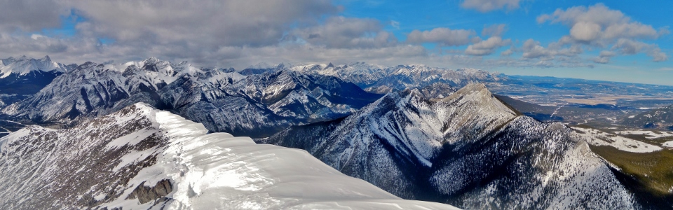
A beautiful winter summit panorama to the south. Click to see larger.
.jpg)
Strong winds blowing Crux’s ears straight up.
.jpg)
The prairies stretch out beyond the front ranges.
.jpg)
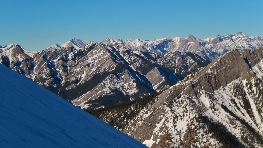
Midnight Peak’s second (equally high) summit lies further along the ridge to the southeast. After breaking trail all day, the extension trip was not even remotely tempting! Tiara Peak is the sharp summit beyond and Mount Bryant lies in the distance.
.jpg)
Mount McDougall to the south.
.jpg)
Front range panorama to the north. Click to see larger.
.jpg)
Tired summit puppy.
.jpg)
Mount Baldy immediately to the north. Door Jamb Mountain, Loder Peak, Yates Mountain and Yamnuska just beyond. Black Rock Mountain visible in the distance on the far right.
.jpg)
Summit selfy.
.jpg)
Looking west towards the larger peaks beyond Nakiska.
.jpg)
Mount Kidd, Mount Sparrowhawk and Wind Mountain beyond the slopes of Nakiska.
.jpg)
Winter sun on Mount Kidd.
.jpg)
One last quick summit shot before retreating from the strong wind and starting our long trip back down.
.jpg)
The long road home: the ups and downs of the west ridge stretch out ahead on descent.
.jpg)
Crux takes a break out of the wind before climbing back up the down climb below the summit. He didn’t so much climb as he got lifted…
.jpg)
Wind Mountain beyond a large cornice.
.jpg)
Following the trail that we broke on ascent made the descent significantly easier.
.jpg)
Last views of Barrier Lake before plunging back into the steep forest.
.jpg)
Enjoying the last of the sun and views before enterting the forest.
.jpg)
An annoying descent through the woods. At this elevation, it was warm enough that my snowshoes just slid straight down slopes like these. Ultimately, I descended most of this section on my butt (sometimes intentionally, sometimes not).
.jpg)
Last views of Midnight Peak following our slip and slide descent through the woods.
.jpg)
.jpg)
.jpg)