After a romantic first anniversary ascent of Eiffel Peak, I treated my wife to an evening of “luxury” in the Lake Louise Inn’s “Pinery” building. The “Pinery’s” timeless decor (circa 1970) and many functional amenities (does the room door count as an “ammentity”?) make it the ideal place for a romantic Lake Louise getaway (if you can’t find a room for under $500/night anywhere else). While the hotel may not have been exceptional, at least the company was!
Better still, spending the night in Lake Louise meant that we would have a second day to spend exploring this beautiful area. In an effort to convince me that there’s more to life than bagging peaks, Brianne insisted that we do something other than scrambling. Happy to accommodate her request for “variety,” I suggested hiking instead (what can I say? I’m a man of diverse interests)! With the benefit of an alpine start, we were able to lace up the boots and make our way up the scenic Plain of Six Glaciers trail on a brisk Sunday morning before the bulk of the hiking hordes arrived.
.jpg)
Fall colors and cool morning air hinted at the changing of the seasons as we hiked along the path which makes its way along Lake Louise’s beautiful shore.
.jpg)
Looking back at the Chateau Lake Louise from the BOTL (back of the lake).
.jpg)
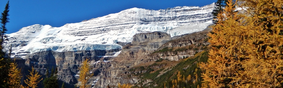
From the BOTL, the well-graded and popular hiking trail whisked us through a brief section of forest and up into the alpine valley formerly occupied by the now-shrinking Victoria Glacier. As it did so, the views towards Mount Lefroy grew more and more spectacular.
.jpg)
The trail contours the south slopes of Mount Whyte above the glacial stream which feeds Lake Louise. In places, the walls of the glacier-carved valley are steep and the trail follows good ledges like the one shown here.
.jpg)
Although the ledges could hardly be called exposed, there is a cable strung along their length to assist any hikers who may be uncomfortable on this section. Here you can see my wife demonstrating improper cable use (very mature dear :-P).
.jpg)
The sun rises over the behemoth peaks across the valley as the trail shifts from hillside to the Victoria Glacier’s lateral moraine. Click to see larger.
.jpg)
Brianne takes in the view of Mount Lefroy from the crest of the moraine.
.jpg)
Moraining her way towards Mount Victoria and the Plain of Six Glaciers.
.jpg)
5.6 km after leaving the crowded lakeshore path, we arrived in the spectacular alpine plain at the base of Pope's Peak from which six glaciers can be seen.
.jpg)
Golden larches add a splash of color to the scene as Mount Victoria towers beyond.
.jpg)
Sun-splashed larches and Mount Aberdeen.
.jpg)
A small creek runs through the Plain of Six Glaciers down towards the valley at the base of the Mitre (center left) and Mount Lefroy (right).
.jpg)
The historic Plain of Six Glaciers teahouse (2070 m). Built in 1924 to serve as a resting point for guests on their way to Abbot Hut (2926 m), today the structure offers home-baked goods and tea to thousands of hikers every year.
.jpg)
Nepali prayer flags: a reminder of our epic Himalayan honeymoon one year ago.
.jpg)
A serac on the Upper Victoria Glacier collapses sending an avalanche rumbling down the mountain’s precipitous rock face.
.jpg)
A closer look at the seracs and the fresh avalanche debris strewn about the ledges below them. While the Plain of Six Glaciers provides an awesome view point, the short 1.3 km hike to the end of the lateral moraine gets you even closer to the action!
.jpg)
Nearing the end of the moraine. Ironically, the sign informing hikers that “the trail is not maintained beyond this point” is, itself, in need of maintenance having been ravaged by an avalanche!
.jpg)
Brianne nears the final viewpoint, high above the crevassed Lower Victoria Glacier. As the large pile of fresh debris (center) at the base of the seracs attests, this is a fine spot to sit and watch for avalanches.
.jpg)
Lake Louise beginning to look awfully small. Meanwhile, my wife looks awfully happy to have arrived at the end of the hike!
.jpg)
Plain of Six Glaciers panorama. From left to right: Mount Aberdeen, the Lefroy Glacier, the rock-covered Lower Victoria Glacier, Mount Lefroy, the Death Trap leading to Abbot’s Pass and Mount Victoria. Click to see larger.
.jpg)
Brianne takes in the views of Abbot’s Pass and the Death Trap.
.jpg)
Looking up towards Abbot’s Hut. The Hut is the second highest habitable structure in Canada and serves as a launching point for mountaineers attempting to climb both Mounts Lefroy and Victoria. Built in 1922, it was named for Philip Abbot who became North America’s first mountaineering fatality when attempting the first ascent of Mount Lefroy in 1896.
.jpg)
Looking up to the standard route on Mount Victoria. This route ascends rock on the left and continues to the right along the long skyline ridge over the “sickle” (an exposed arête on the center left) towards the south (true) summit (out of the photo to the right).
.jpg)
Looking down to the heavily crevassed and rockfall-strewn Lower Victoria Glacier. Between the crevasses, avalanches and rock fall, it’s easy to see why the route up the glacier leading towards Abbot’s Hut is known as “The Death Trap.” Fortunately, a more benign route to the hut from Lake O'Hara on the BC side of the divide is also possible.
.jpg)
A waterfall above the viewpoint. Looks refreshing…
.jpg)
Yep – VERY refreshing! What a perfect way to cool down on a hot September day!
.jpg)
Familiar Skoki peaks beyond Lake Louise and the Lake Louise ski hill (Whitehorn Mountain). From left to right: Mount Richardson, Pika Peak, Ptarmigan Peak, Fossil Mountain, Mount Douglas, Mount Redoubt and snow-capped Mount St. Bride.
.jpg)
After I dried off (and finished embarrassing my wife by showering in the waterfall above), we took a quick “happy anniversary” selfie and started our hike back down towards the lake.
.jpg)
More autumn colors. I love the fall but hate what comes after…
.jpg)
As we retraced our way along the ledges, we noticed that we had an audience watching from above!
.jpg)
Brianne’s cousins (once or twice removed?).
.jpg)
Sheep or goat? Definitely GOAT!!!
.jpg)
After watching the goats (who in turn watched us) for a long time, we resumed our descent, enjoying views of the golden larches on Fairview Mountain before re-entering the forest.
.jpg)
Without a doubt, the crux of the day was elbowing our way back along the crowded 2 km-long crowded lakeshore path. No matter how many long days I’ve done in the Rockies, the hike back along Lake Louise (on a rock hard paved path) always feels really long. At the very least, however, it is scenic and once you’re back at the Chateau, cold anniversary beers are readily available!
.jpg)
.jpg)