Elbow Lake
Elevation: 2120 m
Elevation Gain: 130 m
Nestled at the foot of Mount Rae 120 km upstream of Fort Calgary, Elbow Lake is the headwater of the Elbow River. The river takes its name from the “elbow-like” bend its watercourse takes immediately before flowing into the larger Bow River. The confluence of the Elbow and Bow Rivers marks the site of Fort Calgary which was established in 1873 and around which the current City of Calgary grew.
My Hikes:
August 23 2015.
Trailhead: Elbow Pass Trailhead
With only 6 weeks left until our little bundle of joy (no – not Crux) is due, we decided to take advantage of sunny weather and clear skies by getting out to the mountains. As hiking for two is a difficult task, we sought a short but scenic objective which would get us some fresh air without being too taxing on “mom.” Located 1.3 km from the highway and only 130 m above it, Elbow Lake fit the bill perfectly!
.jpg)
The trail to Elbow Lake initially ascends quite steeply from the Elbow Pass day use area. Fortunately, Crux provided Brianne with a tow up this section which was followed by a very conveniently placed bench. As her pregnancy progresses, benches seem to be Brianne’s favorite part of most hikes! ;-)
.jpg)
Keeping a slow and steady pace, Brianne and I chatted our way up the well-travelled trail. Before we knew it, we’d crested Elbow Pass and reached the beautiful alpine lake swimming hole for dogs. Mouse over to see who we found waiting in the weeds…
.jpg)
It’s not a bench but it will do!
.jpg)
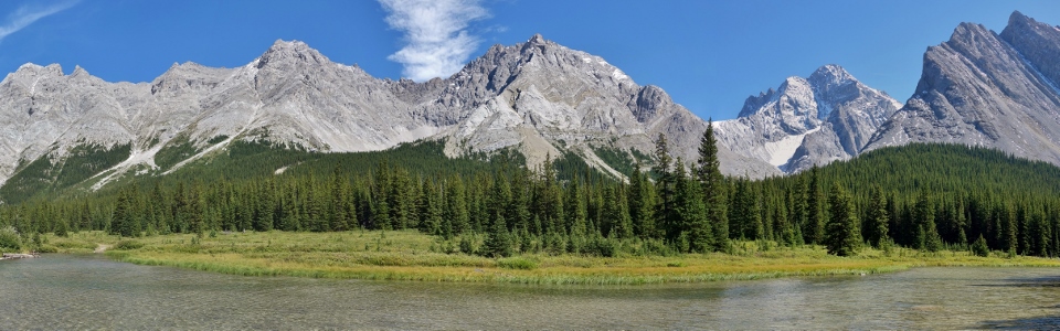
Numerous outliers of Mount Rae rise up along the east shore of Elbow Lake making for a pleasing panorama. Click to see larger.
.jpg)
A popular backcountry campground lies at the base of one such outlier along the scenic shore. This campground’s scenic location and relative proximity to the highway would probably make it a great place for baby’s first backcountry trip (next summer?)!
.jpg)
An even easier way to get up here?
.jpg)
After enjoying a snack and wetting Crux’s paws, we decided to extend the hike by circumnavigating the lake.
.jpg)
Looking back towards Elbow Pass from the far end of the lake. Beyond the pass, Mount Pocaterra rises up above the grassy hills that make up Pocaterra Ridge.
.jpg)
Near the north end of Elbow Lake, Mount Rae (second from the right) finally comes into view amongst its many outliers. Click to see larger.
.jpg)
A closer look at Mount Rae. At 3,218 m elevation, Mount Rae is the highest peak visible from Calgary.
.jpg)
Having rounded the lake, Brianne bravely fords the mighty Elbow River. :-P
.jpg)
The Elbow River gets off to a scenic start.
.jpg)
The Big Elbow trail continues northwards beyond Tombstone Mountain. This trail follows the Elbow River a further 25 km towards the Little Elbow Campground on the eastern edge of the Rocky Mountains. Unfortunately, on this day I couldn’t convince Brianne to explore the trail’s full length. Maybe next time?
.jpg)
Crux and I pose in front of Mount Rae. Rae and I have some history together…
.jpg)
Enjoying the sights (like this one of Elpoca Mountain’s southern outlier) as we make our way back along the opposite shore. Click to see larger.
.jpg)
Finishing off our family-friendly hike with a selfie at the lake. The short hike to Elbow Lake makes for a great outing when time/energy are lacking (or if you're with child) – we’ll definitely be back. The next time that we’re up here, however, there will be a new Hobbs along for the hike!
.jpg)
.jpg)
.jpg)