Mount Haffner
Elevation: 2535 m
Elevation Gain: 1140 m
Mount Haffner was named for Lieutenant Henry John Haffner who was the chief engineer responsible for the construction of the Banff – Windermere road (Highway 93 South). Following his work on the highway, Lieutenant Haffner served with the Eighth Field Company of Engineers during the First World War. It was during this service, that he met an unfortunate end at the hands of an enemy sniper.
My Ascents:
April 3 2015
Trailhead: Numa Falls Trailhead
GPS Track: Mount Haffner
Several months ago, Cory and I completed a viewless repeat ascent of Yates Mountain on a cold and overcast December morning. A lack of scenery as we plodded up to the lookout on Yate’s summit that day prompted discussions of other (hopefully more scenic) outings to come. During this conversation, Mount Haffner was identified as a peak very high on both of our winter ascent wish lists. Haffner’s location near the continental divide in Kootenay National Park assures one of a spectacular summit view on a clear day. A series of e-mails back and forth in the following months kept the aspiration of bagging Haffner alive and, on April 4 (Good Friday), we finally managed to line up our schedules (as well as that of his brother Dave) in order to make an attempt. Now all that we needed was a clear day…
.jpg)
After dragging myself out of bed at 5:00 am (there’s nothing like sleeping in on your day off!), we arrived at the Numa Falls trailhead shortly after 8:00. While Cory and Dave geared up for the day, I made my way down to the banks of the Vermillion River to check out the early morning views of Ochre Peak. After satisfying my photographic urges, we crossed the highway and started to bash our way up Mount Haffner’s west slopes.
.jpg)
Wasn’t this supposed to be a snowshoe ascent? Thanks to an unusually warm and dry winter, we found very little snow on the bottom 200 vertical meters of Mount Haffner. Without the expected snow base, we were forced to thrash through the myriad deadfall left behind by numerous fires which have singed Haffner’s slopes.
.jpg)
Impressive views of an outlier of Numa Mountain across the highway as we make our way uphill amongst the burnt timber.
.jpg)
As we ascended, the snowpack grew steadily deeper, covering annoying deadfall, and allowing for easy travel (even without snowshoes!) on a very supportive surface.
.jpg)
After completing more than half of the required elevation gain, we finally caught our first glimpse of Mount Haffner through the burn. From here, we contoured left to avoid losing elevation, aiming for the Vermillion – Haffner col.
.jpg)
Moss provides a splash of color amongst an otherwise black and white winter landscape.
.jpg)
At the col, the snow (now more than 4 feet deep!) started to become less supportive. After quickly donning our snowshoes, we made our way towards Haffner on increasingly open slopes.
.jpg)
Looking back towards Vermillion Peak and the interceding Vermillion – Haffner col.
.jpg)
A steep outlier of Stanley Peak appears suddenly beyond treed slopes to the north.
.jpg)
Cory breaks trail above tree line as the sun struggles to overcome increasing cloudiness.
.jpg)
Mount Haffner’s summit (right) comes into view beyond deep snow drifts. From here, the safest line to the summit follows the ridge directly as slopes to either side are steep enough to slide.
.jpg)
Rock outcrops enhance the winter scenery up high.
.jpg)
Windswept orange rocks provide the only hint of color on a cloudy Kootenay day. Vermillion Peak (left) remains visible despite the overcast conditions while Mount Whymper (center right) disappears into the white void.
.jpg)
Cory tackles the final (steeper than they look) slopes below the summit. The windswept snow here was rock hard in places and we were thankful for the crampons built into our snowshoes.
.jpg)
An awkward move (mixed climbing? :-P) on steep ice was required to overcome a final buttress. Despite the fact that this was the safest route, I opted to by-pass the buttress to the climber’s left because it looked much easier, the snow pack was rock solid and I was feeling lazy.
.jpg)
A good way to spend Good Friday: on top of Mount Haffner (mind that cornice though)!
.jpg)
The brothers Jaska take their turn for photos atop Haffner.
.jpg)
Kootenay giants attempt to break through the clouds beyond Mount Haffner’s corniced summit. Click to see larger.
.jpg)
A closer look at the cornice.
.jpg)
Massive Stanley Peak is the highlight of the view from Mount Haffner.
.jpg)
Beatrice Peak (left) is just visible above Haffner Creek’s headwaters while Mount Ball remains veiled in cloud. It might be a pain in the ass to get into the hanging valley below these peaks, but it sure is spectacular once you do!
.jpg)
Looking south towards “Haffner Senior.”
.jpg)
Looking spiffy in my bright colors. Talk about haute (literally) couture!
.jpg)
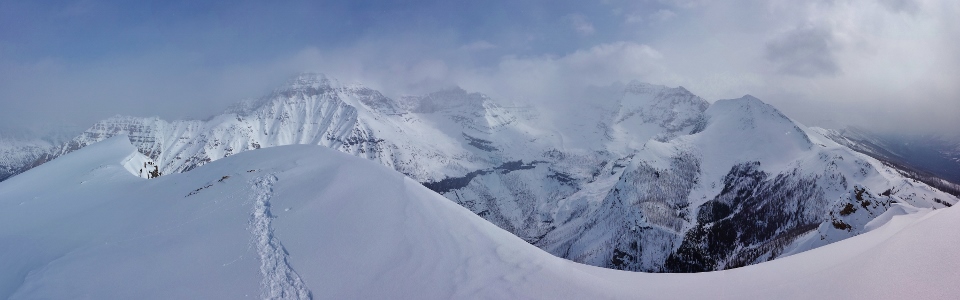
Vermillion River Valley panorama. Click to see larger.
.jpg)
Numa Mountain (center left) across the valley.
.jpg)
A splash of winter sun on Vermillion Peak.
.jpg)
Enjoying some final summit views of Stanley Peak and Beatrice Peak as the feeling begins to depart from our frozen fingers – that can only mean that it’s time to pack up and head back down to warmer elevations!
.jpg)
Cory and Dave blaze a trail back down the mountainside.
.jpg)
Snow and cloud blot out the sun as we make our way down. While it would have been nice to summit under sunny blue skies, the day’s near-constant cloud cover kept the snow rock hard, granting us a very quick (2 hours) and very easy descent…at least until we ran out of snow lower down! All things considered, the day wasn’t as clear as we’d hoped for but, thanks to good company, bomber snow and an impressive atmosphere created by constantly changing clouds, it proved to be a Good Friday after all!
.jpg)
Someday I’m going to climb something with an approach trail. Someday…
.jpg)
.jpg)